Smith Fork (Colorado) facts for kids
Quick facts for kids Smith Fork |
|
|---|---|

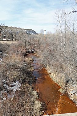
The river as seen from a bridge on Colorado State Highway 92 at Crawford.
|
|
| Physical characteristics | |
| Main source | Confluence of the North Smith Fork Gunnison River and South Smith Fork 38°43′31″N 107°28′23″W / 38.72528°N 107.47306°W |
| River mouth | Confluence with the Gunnison River 5,148 ft (1,569 m). 38°44′14″N 107°50′18″W / 38.73722°N 107.83833°W |
| Basin features | |
| Progression | Gunnison-Colorado |
The Smith Fork is a cool river in western Colorado. It flows through Gunnison and Delta counties. This river is a smaller stream that eventually joins the much larger Gunnison River. When you drive on Colorado State Highway 92 near Crawford, Colorado, you might see signs calling it "Smith Fork Creek."
Where Does the Smith Fork River Begin and End?
The Smith Fork river starts high up in the West Elk Mountains. It forms when two smaller streams, the North Smith Fork Gunnison River and the South Smith Fork, meet.
After flowing for a while, the Smith Fork river joins the Gunnison River. This meeting point is inside the beautiful Gunnison Gorge National Conservation Area.
How Does Smith Fork Help Us?
East of Crawford, there's a special structure called the Smith Fork Diversion Dam. This small dam helps us use the river's water. It sends water from the Smith Fork into a canal called the Smith Fork Feeder Canal.
This canal then carries the water to Crawford Reservoir. The canal and dam were built as part of a bigger plan called the Smith Fork Project. This project is one small part of the huge Colorado River Storage Project, which helps manage water in the western United States.
What Does the Area Around Smith Fork Look Like?
The Smith Fork river flows through an exciting landscape. You'll see mountains and rolling hills all around. A famous landmark nearby is Needle Rock. It's a tall, pointed rock formation that looks like a giant needle sticking out of the ground!
 | Calvin Brent |
 | Walter T. Bailey |
 | Martha Cassell Thompson |
 | Alberta Jeannette Cassell |

