Needle Rock Natural Area facts for kids
Quick facts for kids Needle Rock |
|
|---|---|

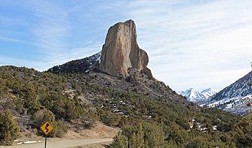
Needle Rock in 2016.
|
|
| Highest point | |
| Elevation | 7,797 ft (2,377 m) |
| Geography | |
| Location | Delta County, Colorado, U.S. |
| Parent range | West Elk Mountains |
| Topo map | USGS 7.5' topographic map Crawford, Colorado |
| Geology | |
| Age of rock | c.a. 28 Ma |
| Mountain type | Igneous Intrusion |
| Climbing | |
| Easiest route | rock |
Needle Rock Natural Area is a cool place found at the western edge of the West Elk Mountains in Colorado. This area is known for its amazing rock formations and beautiful landscapes. It's a great spot to explore nature!
Needle Rock itself is a giant rock spike. It's made of a type of rock called monzonite porphyry. This huge rock sticks out of the ground about 5.6 kilometers (3.5 miles) east-northeast of the town of Crawford in Delta County, Colorado, United States.
This towering rock spire reaches an elevation of 7,797 feet (2,377 meters) above sea level. It stands about 800 feet (244 meters) tall above the valley floor of the Smith Fork of the Gunnison River. Imagine a rock tower as tall as an 80-story building!
How Needle Rock Formed
Needle Rock started forming a very long time ago, about 28 million years ago. This was during a time called the Oligocene geological epoch. Deep underground, hot, melted rock called magma pushed its way up.
This magma squeezed in between layers of existing sedimentary rock. It formed a large, dome-shaped mass called a laccolith. Think of it like a giant bubble of magma pushing up the layers above it.
Over millions of years, the softer rocks around this hard magma cooled and hardened. Wind, water, and ice slowly wore away the softer outer layers. This process, called erosion, gradually exposed the tough, resistant rock that is now Needle Rock.
Today, Needle Rock stands tall as a reminder of these powerful geological forces. It's a natural monument showing how Earth's surface changes over time.
Exploring the Natural Area
The land around Needle Rock is managed by the Bureau of Land Management. This means they help protect the area and keep it safe for visitors. The area is known for its steep cliffs and rocky slopes.
You can also find forests on the flat-topped mountains, called mesas. There are deep canyons and wide, green valleys with plenty of water. It's a diverse landscape with lots to see and do for nature lovers.
 | Jessica Watkins |
 | Robert Henry Lawrence Jr. |
 | Mae Jemison |
 | Sian Proctor |
 | Guion Bluford |


