
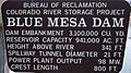
Blue Mesa Dam facts for kids
Quick facts for kids Blue Mesa Dam |
|
|---|---|

Blue Mesa Dam
|
|

Location of Blue Mesa Dam in Colorado
|
|
| Location | Cimarron, Gunnison County, Colorado, USA |
| Coordinates | 38°27′12″N 107°20′04″W / 38.45333°N 107.33444°W |
| Construction began | 1962 |
| Opening date | 1966 |
| Operator(s) | U.S. Bureau of Reclamation |
| Dam and spillways | |
| Type of dam | Zoned earthfill |
| Impounds | Gunnison River |
| Height | 390 feet (120 m) |
| Length | 785 feet (239 m) |
| Dam volume | 3,080,000 cu yd (2,350,000 m3) |
| Spillway type | Two radial gates feeding concrete-lined tunnels to a flip bucket and stilling basin |
| Spillway capacity | 34,000 cu ft/s (960 m3/s) |
| Reservoir | |
| Creates | Blue Mesa Reservoir |
| Total capacity | 940,700 acre-feet (1.1603 km3) |
| Catchment area | 3,470 sq mi (9,000 km2) |
| Surface area | 9,180 acres (3,720 ha) |
| Power station | |
| Hydraulic head | 332 ft (101 m) |
| Turbines | 2 x 43.2 MW Francis turbines |
| Installed capacity | 86.4 MW |
| Annual generation | 203,411,938 KWh |
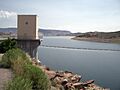
Blue Mesa Dam is a large, 390-foot-tall (120 m) dam built from earth and rock. It stands on the Gunnison River in Colorado. This dam creates the huge Blue Mesa Reservoir. It is located within the Curecanti National Recreation Area. The dam sits just before the river flows into the amazing Black Canyon of the Gunnison National Park.
Blue Mesa Dam is upstream from the Morrow Point Dam. It is part of a bigger project called the Wayne N. Aspinall Unit. This project helps manage the waters of the Colorado River and its smaller rivers. This water is used for farming and for cities in the American Southwest. The dam's main job is to make electricity. State Highway 92 even goes right over the top of the dam. Blue Mesa Dam has two large generators. They produce a lot of electricity, about 264,329,000 kilowatt-hours each year.
Contents
What is Blue Mesa Dam?
| Blue Mesa Dam bridge | |
|---|---|
| Carries | State Highway 92 |
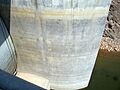
The dam is built in an area with different types of rock. These include sandstone, shale, and older rocks like granite, schist, and gneiss. It is placed at a narrow part of the river valley. This is where the Gunnison River starts to enter the upper part of the Black Canyon of the Gunnison National Park.
The dam itself is very big, with a volume of 3,080,000 cubic yards (2,350,000 m3). It has a special part called a spillway. This spillway has two large gates. These gates release water into a concrete tunnel. The tunnel then sends the water out through a "flip bucket" into a calm pool. This system helps control the water flow safely.
How Blue Mesa Dam Was Built
The idea for the Curecanti Project started in 1955. It was later renamed the Wayne N. Aspinall Project. The plan was approved in 1959. It included building Blue Mesa Dam and Morrow Point Dam. Another dam, Crystal Dam, was approved later in 1962. Plans for a fourth dam were dropped because it would have been too expensive.
The project focused on a 40 miles (64 km) stretch of the Gunnison River. This was above the Black Canyon of the Gunnison National Monument. The dam was first planned to be made of concrete. But the design was changed to an earthfill dam instead.
Work on Blue Mesa Dam began in 1961. Workers started drilling into the ground and surveying the area. Building the reservoir meant moving US 50 and State Highway 149. This road work began in 1962 and finished in 1964. Even the Sapinero Cemetery had to be moved.
The main company for building the dam was Tecon Corporation. They started work on April 23, 1962. A tunnel to divert the river was finished on September 7, 1962. The spillway tunnel was dug out by April 1963. Drilling for the dam's foundation began in March 1963. The Gunnison River was sent through its new tunnel in October. This allowed workers to dig the dam's foundation down to solid rock.
Building the main body of the dam started in 1964 and finished by the end of 1965. The diversion tunnel was partly closed in December, and the reservoir began to fill. The tunnel was fully closed on February 7, 1966. The entire dam project was officially finished on October 19, 1966.
The power plant for the dam had a small delay. A large transformer was damaged in an accident in September 1966. It had to be sent back to Sweden for repairs. The power plant was finally completed on February 16, 1968. Later, in 1984-85, some repairs were made to the spillway. Also, a layer of protective rocks, called riprap, was added to the dam's surface.
How the Powerplant Works
The Blue Mesa Powerplant gets its water from a 16-foot (4.9 m) wide pipe called a penstock. This pipe sends water to two large turbines. These turbines are like giant spinning wheels. The water also feeds other parts of the dam that release water.
The water flowing to the turbines is controlled by very large 156-inch (4.0 m) butterfly valves. When it first opened, the power plant could make 60 megawatts of electricity. In 1988, its power was increased to 86.4 megawatts. The power plant building is located on the ground at the bottom of the dam. It works as a "peaking plant." This means it produces more electricity during times when people need it most.
Images for kids
-
Blue Mesa Dam
-
Very low water levels
-
Blue Mesa Reservoir
.JPG)
.JPG)
.JPG)
