Tomichi Creek facts for kids
Quick facts for kids Tomichi Creek |
|
|---|---|

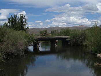
Bridge over Tomichi Creek on the I Bar Ranch property
|
|
| Physical characteristics | |
| Main source | 38°36′06″N 106°23′02″W / 38.60167°N 106.38389°W |
| River mouth | Confluence with Gunnison River 7,618 ft (2,322 m) 38°31′03″N 106°58′08″W / 38.51750°N 106.96889°W |
| Basin features | |
| Progression | Gunnison—Colorado |
Tomichi Creek is a river in Gunnison County, Colorado, about 71.8-mile-long (115.6 km). It's a tributary of the Gunnison River, which means it flows into the Gunnison River.
Tomichi Creek starts in the mountains, north and west of Monarch Pass. It then flows southwest, following the base of Monarch Mountain. Many smaller creeks join Tomichi Creek along its journey. For example, Congress Creek flows into it near Old Monarch Pass. Further along, Agate Creek and Marshall Creek add their waters near Sargents.
After Sargents, Long Branch Creek joins Tomichi Creek. The creek then turns west. Water from Needle Creek Reservoir and Hot Springs Reservoir also flows into Tomichi Creek. The area around the creek is called the Tomichi Valley. This valley is wide and flat, allowing the creek to wind and split into many smaller streams. This makes it a great place for livestock ranches.
Near Parlin, Quartz Creek flows into Tomichi Creek. Tomichi Creek continues its journey west. Finally, Cochetopa Creek joins it near State Highway 114 and U.S. Highway 50. Tomichi Creek then flows into the Gunnison River in the town of Gunnison.
Contents
Exploring Tomichi Creek: Public Access Areas
You can visit certain parts of Tomichi Creek. These areas are called "public access" points. This means they are open for everyone to enjoy outdoor activities like fishing and hiking.
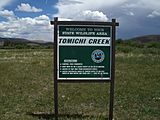
Tomichi Creek State Wildlife Area
One great place to visit is the Tomichi Creek State Wildlife Area. It's located near the Gunnison-Crested Butte Regional Airport. This area has a parking lot and is a good spot for fishing. You can fish here even though some of the land is private, because special permission has been given. You can also hike W Mountain from this area.
Sargents Area Access
Near the town of Sargents, there's a one-mile stretch of Tomichi Creek that's open to the public. You can find it just off US 50. Upstream from Sargents, near Whitepine, you can also find public access at Snowblind Campground.
If you take Marshall Pass Road from US 50 at Sargents, you'll find more public fishing spots. This road also leads to Needle Creek Reservoir. Another area, near Doyleville, is accessible from County Road 46. Along State Highway 114, around mile markers 12, you'll find picnic areas and parking along Cochetopa Creek. These areas are great for fishing. In late summer, you might catch rainbow and brown trout here.
Coleman Easement: Fishing Fun
Near the top of State Highway 114, you'll see a sign for "National Forest Access - Old Agency." If you turn onto this gravel road, you'll reach the Coleman Easement. An "easement" means that even though the land is private, the public has permission to use it for certain activities.
This area is managed by Colorado Parks and Wildlife. It offers about five miles of Cochetopa Creek, two miles of Los Pinos Creek, and a short section of lower Archuleta Creek for public use. These streams are known for their wild trout. You can reach the Coleman Easement by car or other vehicles. It's a special area for "Wild Trout" fishing. Anglers often catch rainbow trout up to 15 inches long here. You can use dry flies, spinners, or heavy nymphs, depending on the water conditions. Remember to always respect private land boundaries.
 | Janet Taylor Pickett |
 | Synthia Saint James |
 | Howardena Pindell |
 | Faith Ringgold |


