Sargents, Colorado facts for kids
Quick facts for kids
Sargents, Colorado
|
|
|---|---|

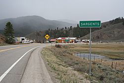
Entering Sargents from the north.
|
|
| Country | |
| State | |
| County | Saguache County |
| Elevation | 8,478 ft (2,584 m) |
| Time zone | UTC-7 (MST) |
| • Summer (DST) | UTC-6 (MDT) |
| ZIP code |
81248
|
| GNIS feature ID | 0204762 |
Sargents is a small, unincorporated community in Saguache County, Colorado. This means it's a settlement that isn't officially governed by its own local town or city government. Sargents also has its own U.S. Post Office with the ZIP code 81248.
Contents
History of Sargents
How Sargents Got Its Name
The community of Sargents started in 1880. It was first called Marshalltown. This name came from a nearby mountain pass called Marshall Pass. In 1882, the community changed its name to Sargents. It was named after Joseph Sargent, who was a local cattle rancher and the town's very first postmaster.
The Railroad's Role
Sargents grew because of the Denver and Rio Grande Railroad. The train line reached Marshalltown in 1881. This railroad crossed the Continental Divide (a line of mountains that separates rivers flowing to different oceans) over Marshall Pass. From there, it went down about 17 kilometers (11 miles) to Marshalltown. Then, it followed Tomichi Creek west to Gunnison. This train line eventually connected Denver, Colorado all the way to Salt Lake City, Utah.
The Sargents train station was very important. It had special "helper engines." These were extra locomotives that helped push heavy trains over the steep mountain pass. The station also had a roundhouse, which was a building for repairing and storing trains. There was also a turntable, a device used to turn trains around. Sargents was a key place for sending out mine ore and lumber from the area. It was also a stop for people traveling to and from mining towns in the Tomichi Creek valley.
Changes After the Railroad
The number of people living in Sargents dropped a lot when the Denver and Rio Grande Railroad stopped carrying passengers in 1940. The entire train line was closed down completely in 1955.
However, a new transcontinental highway, U.S. Highway 50, helped Sargents. This new highway was built in 1939. It goes over the Continental Divide at Monarch Pass (another nearby mountain pass) and then through Sargents. Even today, Sargents offers services like gas stations and restaurants for people traveling on the highway.
Climate in Sargents
Sargents has a type of weather called a warm-summer humid continental climate. This means it has warm summers and cold, snowy winters.
The hottest temperature ever recorded in Sargents was 34 degrees Celsius (94 degrees Fahrenheit) on June 16, 2021. The coldest temperature recorded was -37 degrees Celsius (-35 degrees Fahrenheit) on February 3, 2016.
| Climate data for Sargents, Colorado, 1991–2020 normals, extremes 2012–present | |||||||||||||
|---|---|---|---|---|---|---|---|---|---|---|---|---|---|
| Month | Jan | Feb | Mar | Apr | May | Jun | Jul | Aug | Sep | Oct | Nov | Dec | Year |
| Record high °F (°C) | 53 (12) |
55 (13) |
68 (20) |
78 (26) |
86 (30) |
94 (34) |
93 (34) |
93 (34) |
91 (33) |
84 (29) |
70 (21) |
57 (14) |
94 (34) |
| Mean daily maximum °F (°C) | 33.0 (0.6) |
37.0 (2.8) |
44.8 (7.1) |
54.2 (12.3) |
64.7 (18.2) |
76.4 (24.7) |
81.6 (27.6) |
78.8 (26.0) |
72.6 (22.6) |
60.9 (16.1) |
46.2 (7.9) |
34.2 (1.2) |
57.0 (13.9) |
| Daily mean °F (°C) | 13.8 (−10.1) |
17.1 (−8.3) |
27.1 (−2.7) |
36.9 (2.7) |
45.1 (7.3) |
54.0 (12.2) |
60.2 (15.7) |
57.8 (14.3) |
50.1 (10.1) |
39.0 (3.9) |
27.2 (−2.7) |
15.1 (−9.4) |
37.0 (2.8) |
| Mean daily minimum °F (°C) | −5.4 (−20.8) |
−2.8 (−19.3) |
9.3 (−12.6) |
19.6 (−6.9) |
25.6 (−3.6) |
31.5 (−0.3) |
38.7 (3.7) |
36.8 (2.7) |
27.5 (−2.5) |
17.1 (−8.3) |
8.2 (−13.2) |
−4.0 (−20.0) |
16.8 (−8.4) |
| Record low °F (°C) | −34 (−37) |
−35 (−37) |
−28 (−33) |
−13 (−25) |
8 (−13) |
18 (−8) |
23 (−5) |
23 (−5) |
10 (−12) |
−22 (−30) |
−25 (−32) |
−34 (−37) |
−35 (−37) |
| Average precipitation inches (mm) | 1.27 (32) |
1.28 (33) |
1.21 (31) |
1.47 (37) |
1.23 (31) |
0.76 (19) |
1.63 (41) |
1.59 (40) |
1.30 (33) |
0.98 (25) |
0.90 (23) |
1.13 (29) |
14.75 (374) |
| Average snowfall inches (cm) | 21.5 (55) |
19.0 (48) |
14.6 (37) |
12.1 (31) |
2.7 (6.9) |
0.2 (0.51) |
0.0 (0.0) |
0.0 (0.0) |
0.2 (0.51) |
3.6 (9.1) |
11.8 (30) |
19.6 (50) |
105.3 (268.02) |
| Average precipitation days (≥ 0.01 in) | 7.6 | 7.4 | 6.8 | 7.7 | 6.8 | 5.2 | 12.1 | 10.6 | 7.5 | 6.3 | 5.6 | 7.2 | 90.8 |
| Average snowy days (≥ 0.1 in) | 7.4 | 6.9 | 5.8 | 4.0 | 0.8 | 0.0 | 0.0 | 0.0 | 0.2 | 1.8 | 4.6 | 6.9 | 38.4 |
| Source 1: NOAA | |||||||||||||
| Source 2: National Weather Service | |||||||||||||
 | Dorothy Vaughan |
 | Charles Henry Turner |
 | Hildrus Poindexter |
 | Henry Cecil McBay |


