
Marshall Pass facts for kids
Quick facts for kids Marshall Pass |
|
|---|---|

Marshall Pass in 1899
|
|
| Elevation | 10,842 ft (3,305 m) |
| Location | Colorado, USA |
| Range | Rocky Mountains |
| Coordinates | 38°23′29″N 106°14′50″W / 38.39139°N 106.24722°W |

Location in Colorado
|
|

Marshall Pass is a high mountain pass in the Rocky Mountains of central Colorado, USA. It sits at an elevation of 10,842 ft (3,305 m). This pass is special because it's located on the Continental Divide. This means that water on one side flows towards the Pacific Ocean, and water on the other side flows towards the Atlantic Ocean!
Marshall Pass is found in Saguache County. It's nestled between the Sawatch Range to the north and the Cochetopa Hills to the south. Today, it offers a scenic alternative to U.S. Highway 50 for travelers between Salida and Gunnison. The pass was discovered in 1873 by Lt. William L. Marshall, who was part of the Wheeler Survey, and was named after him.
Contents
History of Marshall Pass
When Lt. William Marshall first explored the pass, he quickly saw that it would be a great place for a road. Soon after, a company was formed to build a special road where people would pay a fee to use it. This was called the Marshall Pass Toll Road.
Building the Toll Road
The Marshall Pass Toll Road was finished in 1880. It allowed stagecoaches to travel from Gunnison to the Arkansas River. From there, people could connect with the Denver and Rio Grande Western Railroad. The road at the very top of the pass was quite rough. Also, the slopes on both sides of the pass were very steep, making travel challenging.
The Railroad Era
In 1881, the Denver and Rio Grande Western Railroad built its narrow gauge main line right across Marshall Pass. This railway was heading from Denver to Salt Lake City. This was a big deal because it was the very first time a railroad crossed the Continental Divide in Colorado. The train line reached Sargents, Colorado, in August 1881. By 1884, the entire line from Ogden, Utah to Denver was complete.
The train line was used daily by a passenger train called the Shavano. People often told stories about a mysterious "phantom train" that seemed to chase the Shavano along the route! The train line eventually closed in 1955, and the tracks were removed that same year.
Marshall Pass, Colorado, was once a small settlement, a railroad station, and even had its own post office. In 1948, only 11 people lived there, and there were just six buildings. Time Magazine even called it "the U.S.'s smallest post office."
Water Diversion at the Pass

In 1939, a company called Catlin Canal Company built something called the Larkspur Ditch. This ditch was made to move water from Harry Creek, which flows into Marshall Creek, over the Continental Divide at Marshall Pass. The water then flows into Poncha Creek and eventually into the South Arkansas River.
The Larkspur Ditch is about 1.5 miles (2.4 km) long. It can carry about 8 cubic feet of water per second. Between 1990 and 1999, it moved about 31 acre-feet of water each year. An acre-foot is how much water it takes to cover one acre of land with water one foot deep.
Later, in 2004, the Lower Arkansas Valley Water Conservancy District worked with the Catlin Canal Company to make the ditch better. They doubled its length, which helped it deliver much more water. By 2011, the water district bought the ditch completely.
Exploring Marshall Pass Today

Marshall Pass is only a few miles south of another well-known pass called Monarch Pass. Both passes were considered for the route of U.S. Highway 50, but Monarch Pass was chosen in the end.
Today, a gravel road still follows the old railroad route over Marshall Pass. This drive is especially beautiful during the summer and late fall. Most regular cars can drive on it when the weather is good.
To get there from the east, you can take U.S. 285 south from Poncha Springs (near Salida) for about 6 miles. Then, turn right onto County Road 200. If you're coming from the west, turn right off U.S. 50 at Sargents.
The slopes on Marshall Pass Road are not as steep as those on U.S. 50 over Monarch Pass. The old railroad had a maximum slope of 4%, while Monarch Pass has 7% slopes. However, remember that Marshall Pass Road is closed to cars and other wheeled vehicles during the winter months. Marshall Pass is often a better route for small airplanes flying over the Continental Divide than Monarch Pass, but not always.
Images for kids
-
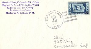
A great deal of Philatelic mail originated at the post office at Marshall Pass
-
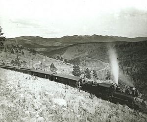
Denver & Rio Grande Railroad train at Marshall Pass, around 1890. Photo by William Henry Jackson.


