
Monarch Pass facts for kids
Quick facts for kids Monarch Pass |
|
|---|---|

Sign at the summit
|
|
| Elevation | 11,312 ft (3,448 m) |
| Traversed by | |
| Location | Chaffee / Gunnison counties, Colorado, U.S. |
| Range | Sawatch Range |
| Coordinates | 38°29′48″N 106°19′32″W / 38.4966636°N 106.3255801°W |
| Topo map | USGS Pahlone Peak |

Monarch Pass
Location in Colorado
|
|
Monarch Pass is a really high mountain pass in the middle of Colorado. It's located in the famous Rocky Mountains, a huge mountain range in the western United States. This pass reaches an amazing height of about 11,312 feet (3,448 m) above sea level!
Contents
Where is Monarch Pass?
Monarch Pass sits right on the Continental Divide. This is like a giant line across North America where water flows either to the Atlantic or Pacific Ocean. The pass is at the southern end of the Sawatch Range of mountains.
It forms the border between Gunnison and Chaffee counties. You can find it about 25 miles (40 km) west of the town of Salida.
Traveling Over the Pass
U.S. Highway 50 crosses over Monarch Pass. This highway connects the Gunnison River basin on the west side with the Arkansas River basin on the east.
- The pass is usually open all year round.
- Most vehicles can drive over it.
- However, some parts have steep 7% grades, which means the road goes up or down very quickly.
- In winter, there's often a lot of snow. This can cause the pass to close temporarily during big storms.
- You'll see special ramps for runaway trucks about halfway down both sides of the pass. These are for trucks that might have trouble with their brakes on the steep slopes.
- Much of the highway over the pass has three lanes, making it easier to drive.
Amazing Views at Monarch Pass
Monarch Pass is known for its beautiful scenery. Many people think it's one of the most scenic passes in Colorado! From the top, you get a wide view of the southern part of the Sawatch Range.
Riding the Aerial Tram
During the summer, you can take an aerial tram from the parking lot at the summit. This tram carries visitors up to the top of Monarch Ridge, which is about 12,000 feet (3,658 m) above sea level. From there, you can see even more of the surrounding mountain peaks.
Skiing Fun in Winter
In winter, Monarch Pass is a great place for skiing! The Monarch ski area is a popular spot for winter sports. If you're looking for a place to stay, Monarch Mountain Lodge is about 5 miles from the pass summit.
History of Monarch Pass
The Monarch Pass we know today is actually the third road to carry that name in the area!
The First Roads
- The very first Monarch Pass was built in 1880. It's located just 1.6 miles (2.6 km) northwest of the current pass.
- This first road was important for wagons and stagecoaches. It connected the town of South Arkansas City (now Salida) with busy mining towns and the city of Gunnison.
- In 1922, the road was improved and moved slightly to better suit cars. This second road is now called Old Monarch Pass. It was an important dirt road until 1939.
Building the Current Highway
In the 1930s, people were working to finish U.S. Route 50 across America. Getting the highway over the Continental Divide in Colorado was a big challenge. Engineers looked at a few different routes, including Marshall Pass and Cochetopa Pass.
In September 1938, state engineer Charles Vail decided to use the Monarch Pass route. But it needed a lot of work! The road was rebuilt and moved to a new spot. This new route helped make the slopes less steep and the curves less sharp. It also kept the road on sunny slopes, which made it easier to clear snow in winter. This new spot was sometimes called Agate Pass.
The new U.S. Route 50 over the divide was mostly finished in November 1939. At first, this new pass was going to be called Vail Pass. But local people didn't like that name. So, in December 1939, Governor Ralph Carr officially named it Monarch Pass. Later, a new pass on U.S. Route 6 to the north was named Vail Pass.
Weather Station at the Summit
There's an automatic weather station at the top of Monarch Pass. It's provided by the Federal Aviation Administration (FAA). This station gives pilots of small airplanes real-time weather information near the summit.
- The high mountains and frequent storms can make flying near Monarch Pass difficult for small planes.
- The pass is steep and narrow, especially when flying from the east.
- Many pilots in Colorado suggest that small planes avoid Monarch Pass if possible. They often recommend using the lower and flatter Marshall Pass instead, which is just a few miles south.
Record-Breaking Wind Gust
On February 17, 2016, the weather station at Monarch Pass recorded a very strong wind gust. It measured 148 miles per hour! This was the highest official wind gust ever recorded in Colorado by the National Weather Service (NWS) at that time. It broke the old record of 147 miles per hour from 1971.
Images for kids
-
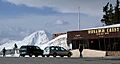
Summit of Monarch Pass in early May
-
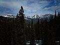
View to the east of the pass
-
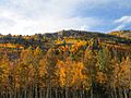
Fall colors along the pass in late September
-

Panoramic View from the Summit


