Vail Pass facts for kids
Quick facts for kids Vail Pass |
|
|---|---|

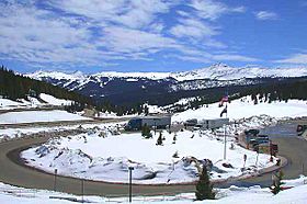
Rest area on Interstate 70 on the east side of Vail Pass. The ski runs at Copper Mountain are visible in the background.
|
|
| Elevation | 10,666 ft (3,251 m) |
| Traversed by | |
| Location | Eagle / Summit counties, Colorado, United States |
| Range | Rocky Mountains |
| Coordinates | 39°31′50″N 106°13′02″W / 39.53056°N 106.21722°W |
| Topo map | USGS Vail Pass |
Vail Pass is a high mountain pass located in the Rocky Mountains of central Colorado. It stands at an elevation of 10,666-foot (3,251 m). A mountain pass is like a low spot or a gap between mountains, making it easier to travel from one side to another. This pass was named after Charles Vail, who was a highway engineer and led the Colorado State Highway Department from 1930 to 1945.
Vail Pass sits right on the border between Eagle County and Summit County. It's found between the towns of Vail to the west and Copper Mountain to the east. The pass is a key route for Interstate 70, a major highway that connects different parts of Colorado. Before I-70, this route was used by U.S. Highway 6.
The pass connects the upper parts of two river basins: the Eagle River and the Blue River. Both of these rivers eventually flow into the larger Colorado River. On the north side of the pass, a stream called Black Gore Creek flows down towards Vail. On the south side, West Tenmile Creek flows down towards the Blue River.
The roads on both sides of Vail Pass are quite steep, with a slope of about 7% to 8%. Because of this, there are special areas called runaway truck ramps on the westbound side. These ramps are designed to help trucks stop safely if their brakes fail while going downhill.
History of Vail Pass
Vail Pass wasn't always the main route through this part of the Rockies. For a long time before 1940, travelers usually took a different path called Shrine Pass, which is located just south of Vail Pass. Shrine Pass led to the town of Red Cliff in the upper Eagle Valley.
However, in 1940, a new road, U.S. Highway 6, was built. This new highway chose the route over what we now call Vail Pass, making it the preferred way to travel to the valley of Gore Creek. This change made Vail Pass an important part of the transportation network in Colorado.
Fun Things to Do at Vail Pass
Vail Pass is a popular spot for outdoor activities, especially during the warmer months.
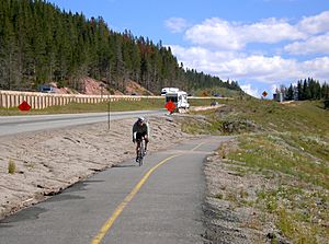
- Biking: There's a special paved bike path that runs alongside I-70 from Vail all the way to the Copper Mountain Ski Area. This path is unique because it's the only pass in Colorado with a paved bike path on both sides for the entire distance. It's an 8.7-mile climb from East Vail, with a total climb of 1,831 feet (558 meters) before descending to Copper Mountain. Many cyclists enjoy this challenging and scenic ride during the summer and fall. This path also connects to several other bike paths in Summit County, allowing for longer rides.
- Winter Sports: When winter arrives and the snow falls, the area around Vail Pass transforms into a playground for snow activities. People enjoy backcountry skiing, which involves skiing in unmarked, ungroomed areas, and snowmobiling, riding motorized vehicles designed for snow.
 | Bessie Coleman |
 | Spann Watson |
 | Jill E. Brown |
 | Sherman W. White |


