Cochetopa Creek facts for kids
Quick facts for kids Cochetopa Creek |
|
|---|---|

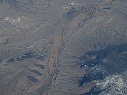
An aerial view of the creek.
|
|
| Physical characteristics | |
| Main source | San Luis Peak in Saguache County, Colorado 37°59′15″N 106°55′32″W / 37.98750°N 106.92556°W |
| River mouth | Confluence with Tomichi Creek 7,821 ft (2,384 m) 38°31′10″N 106°47′20″W / 38.51944°N 106.78889°W |
| Basin features | |
| Progression | Tomichi—Gunnison—Colorado |
Cochetopa Creek is a cool stream in Colorado, United States. It flows through Saguache and Gunnison counties. Imagine a long, winding water path starting high up in the mountains!
This creek begins its journey on San Luis Peak. This peak is part of the La Garita Mountains. The creek then travels quite a distance. It eventually joins up with another stream called Tomichi Creek. This meeting point is close to the small town of Parlin, Colorado. You can find it near Highway 50.
Where Does Cochetopa Creek Flow?
Cochetopa Creek has an interesting path. It flows through a special area known as the Cochetopa Caldera. A caldera is like a giant bowl-shaped dip in the ground. It forms after a volcano erupts and collapses. This caldera is part of the San Juan volcanic field. This means the area was once very active with volcanoes.
The creek also carves its way through Cochetopa Canyon. This is a deep, narrow valley. It's a beautiful place to see. You can even follow part of its path along Colorado State Highway 114.
Part of a Bigger River System
Cochetopa Creek might seem like a small stream. But it's an important part of a much bigger water system. When Cochetopa Creek joins Tomichi Creek, its water continues flowing.
- First, the water from Cochetopa Creek flows into Tomichi Creek.
- Then, Tomichi Creek flows into the Gunnison River.
- Finally, the Gunnison River joins the mighty Colorado River.
So, a drop of water from Cochetopa Creek could eventually travel all the way to the Pacific Ocean! It's amazing how all these waterways connect.
 | Toni Morrison |
 | Barack Obama |
 | Martin Luther King Jr. |
 | Ralph Bunche |

