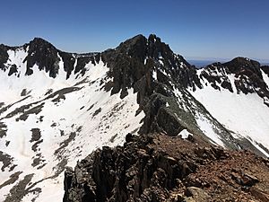
Lavender Peak (Colorado) facts for kids
Quick facts for kids Lavender Peak |
|
|---|---|
| Highest point | |
| Elevation | 13,233 ft (4,033 m) |
| Prominence | 408 ft (124 m) |
| Isolation | 0.50 mi (0.80 km) |
| Parent peak | Hesperus Mountain |
| Geography | |
| Location | Montezuma County, Colorado, United States |
| Parent range | La Plata Mountains |
| Topo map | USGS 7.5' topographic map La Plata, Colorado |
| Climbing | |
| Easiest route | Scramble |
Lavender Peak is a tall mountain in the La Plata Mountains, which are part of the larger Rocky Mountains in North America. This mountain reaches an amazing height of 13,233 feet (about 4,033 meters) above sea level. Because it's over 13,000 feet, it's sometimes called a "thirteener."
About Lavender Peak
Lavender Peak is located in the San Juan National Forest in Montezuma County, Colorado, United States. It's about 13.5 miles (21.7 kilometers) northeast of the town of Mancos.
This peak is also quite close to a taller and more famous mountain called Hesperus Mountain. Lavender Peak is only about half a mile (0.85 kilometers) away from Hesperus Mountain. The easiest way to climb Lavender Peak is by scrambling, which means climbing over rocks and rough terrain using both your hands and feet.
Why the Name "Lavender Peak"?
Lavender Peak was named to honor a person named Dwight Garrigues Lavender. He lived from 1911 to 1934. Dwight Lavender was an author who wrote a special guide in 1932. This guide helped climbers find their way around the San Juan Mountains, which are also part of the Rocky Mountains.
Past Names of the Peak
Over time, mountains can sometimes have different names. Lavender Peak was once spelled "Lavendar Peak." However, in 1976, its official name became Lavender Peak.
 | Leon Lynch |
 | Milton P. Webster |
 | Ferdinand Smith |


