
Sawtooth Mountain facts for kids
Quick facts for kids Sawtooth Mountain |
|
|---|---|
| Highest point | |
| Elevation | 5,354 ft (1,632 m) |
| Geography | |
| Location | Skamania County, Washington, U.S. |
| Parent range | Cascade Range |
| Topo map | Lone Butte O46121a7 1:24,000 |
| Geology | |
| Age of rock | Pleistocene |
| Mountain type | shield volcano |
| Volcanic arc | Cascade Volcanic Arc |
| Climbing | |
| Easiest route | Sawtooth Mountain Trail, Exposed Scramble, class 3 |
Sawtooth Mountain is a cool volcano in Washington, United States. It's a type of volcano called a shield volcano. Imagine a warrior's shield lying on the ground – that's how these volcanoes look, wide and gently sloped.
Sawtooth Mountain is part of a bigger area called the Indian Heaven Volcanic Field. This field has many volcanoes that erupted over a long time. Sawtooth Mountain is located between two famous volcanoes: Mount St. Helens and Mount Adams. It's the third highest point in the Indian Heaven Wilderness area.
The mountain gets its name because it looks like a saw blade. It has sharp, jagged peaks. These peaks are actually old volcanic rocks that have been worn down by wind and water over thousands of years.
Contents
Exploring Sawtooth Mountain
Sawtooth Mountain is a great place for outdoor adventures. It's the third tallest peak in the Indian Heaven Wilderness. This wilderness area is in Washington.
Amazing Views
If you hike on the Sawtooth Mountain Trail, you can see incredible views. On a clear day, you might spot four other huge volcanoes! These are Mount Adams, Mount Hood, Mount St. Helens, and Mount Rainier. The trail goes along the upper western side of Sawtooth Mountain.
Even though it's a mountain, Sawtooth Mountain usually doesn't have snow or ice. But sometimes, snow can stay on the very top until July!
How Sawtooth Mountain Formed
Sawtooth Mountain is a shield volcano. It's one of many shield volcanoes in the Indian Heaven Volcanic Field. This area also has smaller volcanoes called cinder cones and spatter cones.
The Indian Heaven Volcanic Field
The Indian Heaven Volcanic Field is a large area. It stretches for about 19 miles (30 kilometers). This field has about 60 places where lava erupted. The whole volcanic field covers about 230 square miles (600 square kilometers). It's a big part of a larger area of volcanic rock in southern Washington.
Hiking and Fun Activities
The area around Sawtooth Mountain is perfect for hiking and fishing. The Indian Heaven Wilderness is very popular. It has beautiful high mountain meadows. These meadows are found among the volcanic peaks.
Trails to Explore
The Pacific Crest National Scenic Trail goes right through this volcanic area. It runs north to south. This trail is famous for its many lakes. It also offers views of the four nearby volcanoes we talked about earlier.
The Pacific Crest Trail also goes along the eastern side of Sawtooth Mountain. You can hike it with the Sawtooth Mountain Trail. This creates a loop that starts at the Sawtooth Trailhead.
- The Sawtooth Trail climbs up the mountain. It goes along the upper western side.
- The Wood Lake Trail goes down from the Pacific Crest Trail. It leads to a beautiful, deep blue lake called Wood Lake.
Berry Picking
North of Sawtooth Mountain, you'll find the Sawtooth Berry Fields. This area is around Surprise Lakes. It's also near the Sawtooth Trailhead. It's a great spot for picking berries!
Images for kids
-
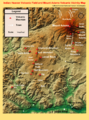
Indian Heaven Volcanic Field and Mount Adams Volcanic Vicinity Digital Relief Map showing Sawtooth Mountain and the various other peaks that make up the volcanic field.

