Lone Cone (Colorado) facts for kids
Quick facts for kids Lone Cone |
|
|---|---|

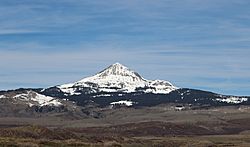
Lone Cone from the south
|
|
| Highest point | |
| Elevation | 12,618 ft (3,846 m) |
| Prominence | 2,273 ft (693 m) |
| Isolation | 8.40 mi (13.52 km) |
| Listing | Colorado prominent summits |
| Geography | |
| Location | Dolores and San Miguel counties, Colorado, United States |
| Parent range | San Miguel Mountains |
| Topo map | USGS 7.5' topographic map Lone Cone, Colorado |
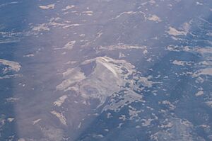
Lone Cone is a tall and noticeable mountain peak in the western part of the San Miguel Mountains range. This mountain is part of the larger Rocky Mountains in North America. Standing at 12,618-foot (3,846 m) (about 3,846 meters) high, it's a very prominent landmark.
You can find Lone Cone about 38.9 kilometers (24.2 miles) west of the Town of Telluride, in Colorado, United States. It sits right on the border between Dolores County and San Miguel County. The mountain helps divide the San Juan National Forest from the Uncompahgre National Forest.
How Lone Cone Was Formed
Lone Cone is a special type of mountain called a laccolith. Imagine a big blob of hot, melted rock, called magma, pushing up from deep inside the Earth. Instead of erupting as a volcano, this magma gets stuck underground. It pushes the layers of rock above it upwards, creating a dome shape.
Over millions of years, the softer rocks on top wear away due to wind and rain. This leaves behind the harder, dome-shaped rock that formed from the magma. That's how Lone Cone became the mountain we see today.
This mountain is between 20 and 40 million years old. It is the westernmost of many laccoliths that are the same age. These formations are similar to rocks found in the San Juan volcanic field.
Past Names for Lone Cone
Over time, this mountain has been known by a few different names.
- Lone Cone – This name was officially used starting in 1906.
- West Point – This was another name used for the mountain.
 | Charles R. Drew |
 | Benjamin Banneker |
 | Jane C. Wright |
 | Roger Arliner Young |


