Uncompahgre Peak facts for kids
Quick facts for kids Uncompahgre Peak |
|
|---|---|

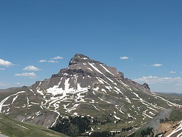
Uncompahgre Peak from the west
|
|
| Highest point | |
| Elevation | 14,321 ft (4365.0 m) NAVD88 |
| Prominence | 4277 ft (1304 m) |
| Isolation | 85.0 mi (136.8 km) |
| Listing |
|
| Geography | |
| Location | High point of Hinsdale County, Colorado, United States |
| Parent range | Highest summit of the San Juan Mountains |
| Topo map | USGS 7.5' topographic map Uncompahgre Peak, Colorado |
| Climbing | |
| Easiest route | Hike (class 2) |
Uncompahgre Peak is a very tall mountain in Colorado, United States. It stands at 14,321 feet (4,365 meters) high. This makes it the sixth highest mountain in Colorado. Mountains over 14,000 feet are often called "fourteeners." Uncompahgre Peak is the highest point in the San Juan Mountains. It is also the highest point in the area where the Colorado River gets its water. You can find it in Hinsdale County, Colorado, about 7 miles (11 km) west of Lake City.
Contents
What Does Uncompahgre Peak Look Like?
Uncompahgre Peak has a wide, flat top, like a huge table. This flat area rises about 1,500 feet (457 meters) above the valleys around it. The sides facing south, east, and west are not very steep. However, the north side has a very tall cliff, about 700 feet (213 meters) high!
How Was Uncompahgre Peak Formed?
Like other mountains in the San Juan Mountains, Uncompahgre Peak was formed by volcanoes. But it's important to know it is not an active volcano itself. The rocks here are not strong enough for difficult climbing, especially on the steep north face.
Hiking to the Top of Uncompahgre Peak
The most popular way to reach the summit of Uncompahgre Peak is by hiking. Hikers use Uncompahgre National Forest Service Trail Number 239. This trail starts at the end of Nellie Creek Road. Nellie Creek Road is a special road that needs a four-wheel drive vehicle to get there. You can find it about 4 miles (6.4 km) west of Lake City.
The Journey to the Summit
The hike to the top is challenging. It climbs about 2,919 feet (890 meters) in elevation. The trail is about 3.5 miles (5.6 km) long. It winds its way up, starting from the east side of the peak. Then it goes over a ridge that points south. Finally, it finishes on the western slopes of the flat summit area.
Where Did the Name Uncompahgre Come From?
The name Uncompahgre comes from the Ute language. The Ute are a Native American tribe. The word roughly means "dirty water" or "red water spring." This name probably refers to the many hot springs in the area near Ouray, Colorado. These springs often have minerals that can make the water look reddish or cloudy.

Historical Names of Uncompahgre Peak
Over time, this mountain has been known by a few different names:
- Unca-pah-gre Mountain
- Uncompahgre Mountain
- Uncompahgre Peak – This became its official name in 1907.
See also
 In Spanish: Pico Uncompahgre para niños
 | Toni Morrison |
 | Barack Obama |
 | Martin Luther King Jr. |
 | Ralph Bunche |


