
Ridgway, Colorado facts for kids
Quick facts for kids
Ridgway, Colorado
|
|
|---|---|

Approaching Ridgway on Highway 62
|
|
| Nickname(s):
Gateway to the San Juans, The Town That Refused to Die
|
|
| Motto(s):
"Think Outside"
|
|

Location of Ridgway in Ouray County, Colorado.
|
|
| Country | United States |
| State | Colorado |
| County | Ouray County |
| Incorporated (town) | April 2, 1891 |
| Named for | Robert M. Ridgway |
| Government | |
| • Type | Home rule municipality |
| Area | |
| • Total | 1.85 sq mi (4.79 km2) |
| • Land | 1.85 sq mi (4.79 km2) |
| • Water | 0.00 sq mi (0.00 km2) |
| Elevation | 6,962 ft (2,122 m) |
| Population
(2020)
|
|
| • Total | 1,183 |
| • Density | 639.5/sq mi (247.0/km2) |
| Time zone | UTC-7 (Mountain (MST)) |
| • Summer (DST) | UTC-6 (MDT) |
| ZIP code |
81432
|
| Area code(s) | 970 |
| FIPS code | 08-64200 |
| GNIS feature ID | 2412551 |
The Town of Ridgway is the most populated town in Ouray County, Colorado, United States. It's a special kind of town called a "home rule municipality," which means it has its own local government rules.
Ridgway used to be a train stop along the Uncompahgre River. It sits in the northern part of the beautiful San Juan Mountains. In 2020, about 1,183 people lived there.
Tall, tree-covered mountains and cliffs surround Ridgway on three sides. The Uncompahgre River flows through the town. It then goes into the Ridgway State Park and Reservoir, which is north of town. Another creek, Dallas Creek, also joins the Uncompahgre River before it reaches the reservoir.
This area is full of wildlife! You might see mountain lions, badgers, deer, elk, bears, coyotes, wild turkeys, and even bald eagles. Bald eagles often build their nests in the tall cottonwood trees along the river. You can often spot them in the late fall.
Ridgway has also been featured in many movies. It was the main setting for John Wayne's western movie True Grit. Other movies filmed here include How the West Was Won and Tribute to a Bad Man. Ridgway is unique because it has the only stoplight in all of Ouray County! You'll find it where Highways 550 and 62 meet.
Contents
History of Ridgway
Ridgway started as a town built around trains. It helped connect the nearby mining towns of Telluride and Ouray.
The Railroad Town

The town was set up where two important train lines met. The Rio Grande Southern Railroad ended here, connecting with the Denver and Rio Grande Western Railroad. This second line ran between Montrose and Ouray. Ridgway was officially started on April 2, 1891. It was known as the "Gateway to the San Juans" because it was a central point for trains going to the mining towns. The town was named after Robert M. Ridgway, a superintendent for the Denver and Rio Grande railroad.
Over time, the need for trains changed. The Rio Grande Southern train line stopped running in 1952. The line between Ridgway and Ouray also closed in 1953. The train line from Ridgway to Montrose was updated. Ridgway kept shipping goods by train until 1976. This was when a new reservoir was built on the Uncompahgre River.
The Town That Refused to Die
A plan for a dam and reservoir, called the Ridgway Dam, came up in 1957. The original idea was to build the dam in a spot that would have flooded Ridgway. But in 1975, a decision was made to build the dam further downstream. This saved the town from being underwater! Because of this, the people of Ridgway gave their town a special nickname: "The Town that Refused to Die." The land around the new reservoir became Ridgway State Park, just north of town.
Geography and Nature

Ridgway is located in the Uncompahgre Valley. It sits at an elevation of about 6,985 feet (2,129 meters) above sea level. The town is part of the San Juan Skyway, a scenic drive. It is surrounded by some of the most photographed mountains in the world.
Majestic Mountains
The nearby San Juan Mountain Range has 14 peaks that are over 14,000 feet (4,267 meters) tall. These are called "fourteeners." One of the most famous peaks seen from Ridgway is Mt. Sneffels, which is 14,150 feet (4,313 meters) high. There's also a mountain named after the town, Mt. Ridgway, which is 13,468 feet (4,105 meters) tall. To the east, you can see the Cimarron Range. Its tallest peak, Uncompahgre Peak, is 14,309 feet (4,361 meters) high.
The Uncompahgre River
The Uncompahgre River starts high up in the mountains. It flows northwest through towns like Ouray, Ridgway, and Montrose. The river eventually joins the Gunnison River in Delta. The word "Uncompahgre" comes from a Ute Native American word. It means "dirty water" or "red water spring." This name probably refers to the many hot springs found near Ouray. The river is used to water farms in the valley. Lake Otonawanda is the main source of drinking water for Ridgway.

Climate and Weather
Ridgway has four clear seasons. Summers are usually warm or hot. Winter days are cold, and temperatures can drop close to zero at night. The town gets a lot of snow, with about 85 inches (216 cm) falling each year.
| Climate data for Ridgway, Colorado, 1991–2020 normals, extremes 1982–present | |||||||||||||
|---|---|---|---|---|---|---|---|---|---|---|---|---|---|
| Month | Jan | Feb | Mar | Apr | May | Jun | Jul | Aug | Sep | Oct | Nov | Dec | Year |
| Record high °F (°C) | 62 (17) |
65 (18) |
76 (24) |
80 (27) |
89 (32) |
98 (37) |
98 (37) |
96 (36) |
96 (36) |
85 (29) |
74 (23) |
65 (18) |
98 (37) |
| Mean maximum °F (°C) | 53.9 (12.2) |
56.4 (13.6) |
66.7 (19.3) |
73.2 (22.9) |
81.2 (27.3) |
89.5 (31.9) |
92.1 (33.4) |
89.1 (31.7) |
85.6 (29.8) |
77.5 (25.3) |
66.4 (19.1) |
54.9 (12.7) |
92.8 (33.8) |
| Mean daily maximum °F (°C) | 40.3 (4.6) |
44.0 (6.7) |
52.5 (11.4) |
58.8 (14.9) |
69.7 (20.9) |
81.3 (27.4) |
85.4 (29.7) |
82.3 (27.9) |
75.8 (24.3) |
63.9 (17.7) |
50.7 (10.4) |
39.9 (4.4) |
62.0 (16.7) |
| Daily mean °F (°C) | 23.4 (−4.8) |
27.9 (−2.3) |
36.3 (2.4) |
42.5 (5.8) |
51.6 (10.9) |
60.3 (15.7) |
65.8 (18.8) |
63.4 (17.4) |
56.0 (13.3) |
44.8 (7.1) |
33.6 (0.9) |
23.8 (−4.6) |
44.1 (6.7) |
| Mean daily minimum °F (°C) | 6.5 (−14.2) |
11.9 (−11.2) |
20.2 (−6.6) |
26.2 (−3.2) |
33.6 (0.9) |
39.4 (4.1) |
46.3 (7.9) |
44.6 (7.0) |
36.2 (2.3) |
25.7 (−3.5) |
16.4 (−8.7) |
7.6 (−13.6) |
26.2 (−3.2) |
| Mean minimum °F (°C) | −11.8 (−24.3) |
−7.2 (−21.8) |
2.4 (−16.4) |
13.8 (−10.1) |
22.6 (−5.2) |
29.8 (−1.2) |
38.0 (3.3) |
36.7 (2.6) |
24.5 (−4.2) |
12.2 (−11.0) |
−3.0 (−19.4) |
−12.0 (−24.4) |
−17.6 (−27.6) |
| Record low °F (°C) | −33 (−36) |
−36 (−38) |
−21 (−29) |
3 (−16) |
16 (−9) |
19 (−7) |
30 (−1) |
29 (−2) |
14 (−10) |
−6 (−21) |
−18 (−28) |
−26 (−32) |
−36 (−38) |
| Average precipitation inches (mm) | 1.02 (26) |
0.92 (23) |
1.27 (32) |
1.43 (36) |
1.50 (38) |
0.81 (21) |
1.87 (47) |
2.04 (52) |
1.59 (40) |
1.36 (35) |
1.21 (31) |
1.10 (28) |
16.12 (409) |
| Average snowfall inches (cm) | 13.6 (35) |
12.6 (32) |
13.6 (35) |
7.3 (19) |
1.4 (3.6) |
0.0 (0.0) |
0.0 (0.0) |
0.0 (0.0) |
0.3 (0.76) |
4.4 (11) |
11.4 (29) |
16.4 (42) |
81.0 (206) |
| Average extreme snow depth inches (cm) | 9.9 (25) |
9.5 (24) |
7.1 (18) |
4.5 (11) |
1.3 (3.3) |
0.0 (0.0) |
0.0 (0.0) |
0.0 (0.0) |
0.2 (0.51) |
3.6 (9.1) |
7.1 (18) |
9.8 (25) |
13.4 (34) |
| Average precipitation days (≥ 0.01 in) | 6.2 | 6.4 | 6.4 | 7.7 | 7.5 | 4.4 | 10.2 | 11.4 | 7.8 | 5.9 | 5.8 | 6.7 | 86.4 |
| Average snowy days (≥ 0.1 in) | 5.8 | 4.9 | 4.6 | 2.5 | 0.6 | 0.0 | 0.0 | 0.0 | 0.1 | 1.4 | 3.5 | 6.1 | 29.5 |
| Source 1: NOAA | |||||||||||||
| Source 2: National Weather Service | |||||||||||||
People of Ridgway

In 2010, there were 924 people living in Ridgway. About 31.4% of homes had children under 18. The average age of people in Ridgway was 43.7 years old.
Population Growth
Ridgway's population has changed a lot over the years. Here's how it has grown:
| Historical population | |||
|---|---|---|---|
| Census | Pop. | %± | |
| 1900 | 245 | — | |
| 1910 | 376 | 53.5% | |
| 1920 | 400 | 6.4% | |
| 1930 | 239 | −40.2% | |
| 1940 | 354 | 48.1% | |
| 1950 | 209 | −41.0% | |
| 1960 | 254 | 21.5% | |
| 1970 | 262 | 3.1% | |
| 1980 | 369 | 40.8% | |
| 1990 | 423 | 14.6% | |
| 2000 | 713 | 68.6% | |
| 2010 | 924 | 29.6% | |
| 2020 | 1,183 | 28.0% | |
| U.S. Decennial Census | |||
Fun Things to Do in Ridgway
Ridgway is a popular place for tourists. It's a great starting point to visit other mountain towns in the San Juan region. Ridgway is about 37 miles (60 km) east of Telluride and 10 miles (16 km) north of Ouray. The town also offers amazing views of the San Juan Mountains.
The Grammy Awards Connection
Did you know that the famous Grammy Award trophies are made right here in Ridgway? A craftsman named John Billings, also known as the 'Grammy Man,' and his team create them. Each trophy is made by hand from a special metal alloy called grammium. Then, they are carefully shaped, polished, and covered in 24-karat gold.
A Certified Creative District
Ridgway is officially known as a "State-Certified Creative District." This means the town is recognized for its focus on arts and culture. The idea started in 2011 to help the local economy grow through creative industries. In 2013, Ridgway earned this special title. This helps support artists and creative businesses in the area.
The Historic Sherbino Theater
The Sherbino Theater is a very old and important building in downtown Ridgway. The Sherbino family has been part of Ridgway since before the town was even officially formed. In 1915, Louis Sherbino built the theater. It opened with a big celebration on September 11, 1915. About 400 people came to the opening! The newspaper said it had seating for 300 people, hot and cold running water, and even toilets!
The Sherbino building has been used for many things over the years. People gathered there in 1917 to hear that the U.S. had joined World War I. It has hosted concerts, plays, and educational events. It was even used as a roller skating rink and a boxing arena once! The outside of the building was even in the 1968 movie True Grit.
Today, a group called The Ridgway Chautauqua Society owns and takes care of the Sherbino. They also manage The 610 Arts Collective next door. These places continue to be important centers for arts and community events in Ridgway.
Water Fun
Water is a big part of life and fun in Ridgway. The town has a marina at the northern end of the Ridgway Reservoir. In the warm summer months, many visitors and locals enjoy the reservoir. They go wakeboarding or spend the day at the beach.
Ridgway also has Orvis Hot Springs. This is a natural hot springs resort where you can relax in warm, mineral-rich waters.
Famous People from Ridgway
Many interesting people have lived in Ridgway, including:
- Leslie Chang, a journalist
- Charlie Ergen, who helped start EchoStar Communications
- Thomas Friedkin, a businessman and Hollywood stunt pilot
- Peter Hessler, a non-fiction writer
- Ralph Lauren, a famous fashion designer
- PattiSue Plumer, an Olympic runner
- Danny Thompson, a race car driver
- Dennis Weaver, an actor who won an Emmy Award
- Trevor White, a movie producer
Getting Around Ridgway
The closest airport with regular flights is Montrose Regional Airport. It is about 28 miles (45 km) north of Ridgway. Ridgway is also part of Colorado's Bustang bus system. You can catch the Durango-Grand Junction Outrider bus line here.
Main Roads
 U.S. Highway 550 starts 27 miles (43 km) north of Ridgway in Montrose. It goes all the way to Bernalillo, New Mexico, near Albuquerque.
 State Highway 62 is about 23.4 miles (37.7 km) long. It connects Ridgway to State Highway 145 near Placerville.
Images for kids
-
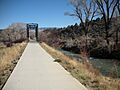
Path along the Uncompaghre river that leads from the town to the reservoir
-

Ridgway Town Hall
-
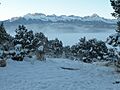
Morning near Ridgway after heavy snowfall
See also
 In Spanish: Ridgway (Colorado) para niños
