Colorado Trail facts for kids
Quick facts for kids Colorado Trail |
|
|---|---|
| Length | 486 mi (782 km) |
| Location | Colorado, United States |
| Trailheads | |
| Use | Hiking, biking and horseback riding |
| Highest point | 12 mi (19 km) south of Lake City , 13,271 ft (4,045 m) |
| Lowest point | Mouth of Waterton Canyon (Denver terminus), 5,500 ft (1,700 m) |
| Difficulty | Moderate to strenuous |
| Season | Primarily July–September |
| Sights | Rocky Mountains |
| Hazards | Severe weather |
| Website | http://www.coloradotrail.org |
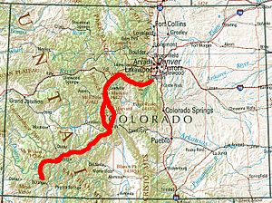
The Colorado Trail is an amazing adventure path in Colorado, United States. It stretches for about 486 miles (782 km) (782 km) from near Denver all the way to Durango. Imagine walking or biking across nearly the entire state!
This trail takes you through the incredible Rocky Mountains. You'll reach heights of 13,271 feet (4,045 m) (4,045 m) above sea level. Most of the trail is very high up, often above 10,000 feet (3,000 m) (3,048 m). Even with these high points, the trail often dips into forests. These lower spots offer a safe place from storms that can happen in the open mountains.
The Colorado Trail was finished in 1987. It is cared for by the Colorado Trail Foundation and the United States Forest Service. These groups work hard to keep the trail ready for everyone to enjoy.
Contents
Exploring the Colorado Trail
The Colorado Trail is a well-known and marked path. Most of it is just for hikers, horse riders, and bicyclists. It starts southwest of Denver at Waterton Canyon. From there, it winds through Colorado's most mountainous areas. The trail ends about 3.5 miles (5.6 km) (5.6 km) north of Durango.
Along the way, you will travel through eight different mountain ranges. You will also see six National Forests and six special wilderness areas. These are places where nature is protected and kept wild.
The trail's elevation changes a lot. It goes from about 5,500 feet (1,700 m) (1,676 m) near Denver to its highest point of 13,271 feet (4,045 m) (4,045 m) in the San Juan Mountains. If you hike the whole trail, you will climb and descend about 89,000 vertical feet! That's like climbing a very tall mountain many times over.
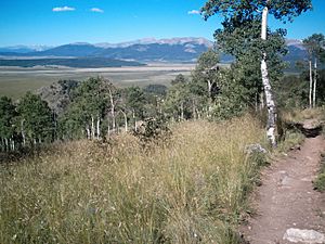
You will see some of Colorado's most beautiful scenery. There is lots of wildlife, and many colorful wildflowers bloom in season. While much of the trail goes through forests, some parts are above the timberline. This means there are no trees, and the views are absolutely amazing!
The trail also passes through old mining towns and along ancient Native American paths. You might even see a modern ski resort. Other parts of the trail look just as they did hundreds of years ago. The western half of the trail, between Monarch Pass and Durango, feels wilder. It has bigger views and even more spectacular wildflowers.
For about 235 miles (378 km) (378 km), the Colorado Trail shares its path with the Continental Divide Trail. This is another famous long-distance trail.
Mountain Weather
Summer days on the trail are usually warm, and nights are cool. But mountain weather can change very quickly. It can even snow in any month of the year! Strong thunderstorms with lightning can appear in the afternoon. However, they often clear up fast, leaving sunny skies.
There is a 35 miles (56 km) (56 km) section of the trail that is above the tree line. This means there is no shelter from thunderstorms. Hikers need to be very careful and prepared for sudden weather changes.
The best time to hike the entire Colorado Trail is usually July, August, and September. Parts of the trail near Denver, at lower elevations, can be hiked earlier, from April to June. In winter, deep snow makes many parts of the trail too difficult to use.
Hiking the Whole Trail (Thru-hiking)

Many people who hike the entire trail in one trip are called "thru-hikers." Most thru-hikers start from the east and head west. This is because the snow usually melts earlier on the eastern part of the trail. Also, starting in the east means you begin with easier climbs. This helps you get ready for the tougher mountains in the western San Juan Mountains.
How long it takes to thru-hike the Colorado Trail varies a lot. Some super-fast runners can finish it in less than 10 days! But most thru-hikers take about 4 to 6 weeks (28 to 42 days) to complete the journey. It's a big adventure that takes time and effort.
Mountain Biking Adventures
The Colorado Trail is special because it allows mountain biking. Many other long trails do not. Most of the trail is open to bikes. However, there are six special wilderness areas where bikes are not allowed by law.
The trail offers something for all levels of bicyclists. Beginners can enjoy easier sections. Experienced cyclists consider it one of the best long-distance trails in the world. It's a fantastic place for a biking adventure!
The Colorado Trail Foundation
The Colorado Trail Foundation (CTF) is a non-profit group based in Golden, Colorado. They are in charge of keeping the Colorado Trail in great shape. Every year, about 600 volunteers and 3,000 donors help the CTF. They maintain over 500 miles (800 km) (800 km) of trail.
Each summer, their trail crews work for many weeks. They clear fallen trees, fix problems that cause erosion, and make sure signs are clear. They also have an "Adopt-A-Trail" program. Volunteers can "adopt" a section of the trail, usually about eight miles long, to help maintain it.
The CTF also offers guided week-long treks on the trail each summer. They provide guides and support staff for hikers. The Foundation has a helpful website with lots of information. They also publish books and guides for hikers.
Trail History
The idea for the Colorado Trail started in 1973. It took many years of hard work by different groups and volunteers. The trail was finally connected from end to end in 1987. The Colorado Trail Foundation grew from these efforts. It continues to work with the United States Forest Service to care for the trail.
Location coordinates
| Point | Coordinates (links to map & photo sources) |
Notes |
|---|---|---|
| Eastern Terminus | 39°29′29″N 105°05′41″W / 39.491325°N 105.094594°W | Waterton Canyon, lowest point: 5,500 ft |
| Midpoint | 38°19′02″N 106°30′44″W / 38.317105°N 106.512189°W | |
| Highest Point | 37°51′24″N 107°20′45″W / 37.856781°N 107.345737°W | 13,271 ft |
| Western Terminus | 37°19′53″N 107°54′10″W / 37.331389°N 107.902778°W | Near Durango |
 | Chris Smalls |
 | Fred Hampton |
 | Ralph Abernathy |


