Crested Butte, Colorado facts for kids
Quick facts for kids
Crested Butte, Colorado
|
|
|---|---|

Crested Butte – the town and mountain
|
|
| Nicknames:
Wildflower Capital of Colorado
The last great Colorado ski town |
|

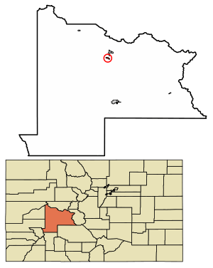
Location of the Town of Crested Butte in Gunnison County, Colorado.
|
|
| Country | |
| State | |
| County | Gunnison County |
| Incorporated | July 15, 1880 |
| Government | |
| • Type | Home rule municipality |
| Area | |
| • Total | 0.836 sq mi (2.166 km2) |
| • Land | 0.836 sq mi (2.166 km2) |
| • Water | 0 sq mi (0.000 km2) |
| Elevation | 8,865 ft (2,702 m) |
| Population
(2020)
|
|
| • Total | 1,639 |
| • Density | 1,960/sq mi (760/km2) |
| Time zone | UTC−07:00 (MST) |
| • Summer (DST) | UTC−06:00 (MDT) |
| ZIP Codes |
81224 & 81225 (PO Box)
|
| Area code(s) | 970 |
| FIPS code | 08-18310 |
| GNIS feature ID | 2412385 |
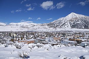
Crested Butte is a small town in Gunnison County, Colorado, United States. It's known for its beautiful mountains and outdoor activities. In 2020, about 1,639 people lived there.
Crested Butte used to be a coal mining town. Today, it's a popular spot for skiing, mountain biking, and other fun adventures in nature.
Contents
History of Crested Butte
The area where Crested Butte is located was once a summer home for the Ute people. However, they were soon moved away when European-Americans arrived. The first white explorers in the valley were trappers, followed by surveyors. Captain John W. Gunnison, for whom Gunnison County is named, was one of these early explorers.
In the 1860s and 1870s, mines for coal and silver opened nearby. Many small mining towns grew up around them. Mining and ranching were the main jobs. When silver mining slowed down, many of these towns disappeared. Crested Butte survived because it supplied goods to the other mining areas.
When the coal mines eventually closed, the town became much smaller. The local high school even closed down. Students had to travel to Gunnison for high school.
The town started to grow again in the 1960s when a ski area was built. This ski resort was built on the old Malensek Ranch, in what is now Mt. Crested Butte. The resort brought new life to the town's economy through tourism.
Because of this new growth, Crested Butte slowly brought back its schools. In 1990, middle school classes started in the old railroad building. A new middle school was finished in 1992, allowing students from kindergarten to 8th grade to attend. Finally, in 1997, a new school building was completed, adding a public high school. Now, the Crested Butte Community School teaches students from kindergarten all the way to 12th grade.
The town has changed a lot, from a mining town to a popular tourist spot. This has made homes in Crested Butte very expensive. In 1990, the Colorado General Assembly officially named Crested Butte the wildflower capital of Colorado.
Geography and Climate
Crested Butte is in the northern part of Gunnison County. It sits on the west side of the Slate River valley, next to Coal Creek. Colorado State Highway 135 goes south from Crested Butte for about 27 miles to Gunnison, which is the county seat.
The town covers about 0.84 square miles of land. Crested Butte is very high up, at an elevation of about 8,885 feet above sea level.
Weather in Crested Butte
Crested Butte has a cold climate, especially in winter. Winters are long and very cold, with clear days and lots of snow. It doesn't rain much, but it snows a lot! The record snowfall was 415 inches in the winter of 1977-1978.
| Climate data for Crested Butte, Colorado, 1991–2020 normals, extremes 1910–present | |||||||||||||
|---|---|---|---|---|---|---|---|---|---|---|---|---|---|
| Month | Jan | Feb | Mar | Apr | May | Jun | Jul | Aug | Sep | Oct | Nov | Dec | Year |
| Record high °F (°C) | 54 (12) |
52 (11) |
58 (14) |
72 (22) |
80 (27) |
89 (32) |
89 (32) |
91 (33) |
87 (31) |
78 (26) |
69 (21) |
60 (16) |
91 (33) |
| Mean maximum °F (°C) | 38.0 (3.3) |
42.4 (5.8) |
50.5 (10.3) |
61.1 (16.2) |
71.7 (22.1) |
80.2 (26.8) |
83.8 (28.8) |
81.0 (27.2) |
77.0 (25.0) |
68.9 (20.5) |
55.7 (13.2) |
41.3 (5.2) |
84.4 (29.1) |
| Mean daily maximum °F (°C) | 25.8 (−3.4) |
29.4 (−1.4) |
37.0 (2.8) |
46.9 (8.3) |
58.3 (14.6) |
70.2 (21.2) |
76.1 (24.5) |
73.5 (23.1) |
65.9 (18.8) |
54.3 (12.4) |
39.4 (4.1) |
26.8 (−2.9) |
50.3 (10.2) |
| Daily mean °F (°C) | 9.6 (−12.4) |
13.7 (−10.2) |
22.4 (−5.3) |
33.0 (0.6) |
43.4 (6.3) |
51.9 (11.1) |
57.8 (14.3) |
55.9 (13.3) |
48.6 (9.2) |
38.2 (3.4) |
24.3 (−4.3) |
11.3 (−11.5) |
34.2 (1.2) |
| Mean daily minimum °F (°C) | −6.5 (−21.4) |
−2.1 (−18.9) |
7.0 (−13.9) |
19.1 (−7.2) |
28.5 (−1.9) |
33.7 (0.9) |
39.5 (4.2) |
38.4 (3.6) |
31.2 (−0.4) |
22.0 (−5.6) |
9.3 (−12.6) |
−4.2 (−20.1) |
18.0 (−7.8) |
| Mean minimum °F (°C) | −27.8 (−33.2) |
−25.4 (−31.9) |
−16.4 (−26.9) |
3.0 (−16.1) |
17.4 (−8.1) |
25.6 (−3.6) |
31.3 (−0.4) |
30.6 (−0.8) |
20.2 (−6.6) |
7.0 (−13.9) |
−15.4 (−26.3) |
−26.1 (−32.3) |
−31.0 (−35.0) |
| Record low °F (°C) | −43 (−42) |
−47 (−44) |
−42 (−41) |
−17 (−27) |
−1 (−18) |
15 (−9) |
17 (−8) |
17 (−8) |
3 (−16) |
−13 (−25) |
−30 (−34) |
−39 (−39) |
−47 (−44) |
| Average precipitation inches (mm) | 2.72 (69) |
2.54 (65) |
2.09 (53) |
2.01 (51) |
1.52 (39) |
0.93 (24) |
1.96 (50) |
1.98 (50) |
1.95 (50) |
1.71 (43) |
2.04 (52) |
2.31 (59) |
23.76 (605) |
| Average snowfall inches (cm) | 42.2 (107) |
35.2 (89) |
29.1 (74) |
19.4 (49) |
6.7 (17) |
0.3 (0.76) |
0.0 (0.0) |
0.0 (0.0) |
1.2 (3.0) |
8.5 (22) |
25.3 (64) |
35.1 (89) |
203.0 (516) |
| Average extreme snow depth inches (cm) | 32.9 (84) |
39.9 (101) |
37.7 (96) |
19.0 (48) |
3.7 (9.4) |
0.1 (0.25) |
0.0 (0.0) |
0.0 (0.0) |
0.3 (0.76) |
3.0 (7.6) |
11.7 (30) |
22.5 (57) |
43.0 (109) |
| Average precipitation days (≥ 0.01 in) | 11.5 | 11.8 | 9.8 | 9.7 | 8.0 | 5.9 | 10.4 | 12.0 | 9.5 | 7.8 | 8.9 | 11.2 | 116.5 |
| Average snowy days (≥ 0.1 in) | 11.7 | 11.7 | 9.7 | 8.3 | 3.3 | 0.2 | 0.0 | 0.0 | 0.5 | 3.9 | 8.5 | 11.3 | 69.1 |
| Source: NOAA | |||||||||||||
Population Changes
| Historical population | |||
|---|---|---|---|
| Census | Pop. | %± | |
| 1890 | 857 | — | |
| 1900 | 988 | 15.3% | |
| 1910 | 904 | −8.5% | |
| 1920 | 1,213 | 34.2% | |
| 1930 | 1,251 | 3.1% | |
| 1940 | 1,145 | −8.5% | |
| 1950 | 730 | −36.2% | |
| 1960 | 289 | −60.4% | |
| 1970 | 372 | 28.7% | |
| 1980 | 959 | 157.8% | |
| 1990 | 878 | −8.4% | |
| 2000 | 1,529 | 74.1% | |
| 2010 | 1,487 | −2.7% | |
| 2020 | 1,639 | 10.2% | |
| U.S. Decennial Census | |||
In 2000, there were 1,529 people living in Crested Butte. The average age of people in the town was 31 years old.
Fun Festivals and Activities
Crested Butte has many fun festivals and parades throughout the year.
Winter Events
- Torchlight
- New Years
- Winter Carnival
- Butte Bash College Ski Week
- Mardi Gras
Spring Events
- Extreme Board Fest
- Slushuck
- Flauschink
Summer Events
- Crested Butte Bike Week
- Crested Butte Music Festival
- Crested Butte International Film Festival
- 4th of July celebration
- Crested Butte Wildflower Festival
- Alpenglow Concert Series
- Festival of the Arts
- Ball Bash
Fall Events
- Fall Fest
- Vinotok
- Paragon Peoples' Fair
Parks and Outdoor Fun
Crested Butte has a Nordic Center where you can go ice skating and cross-country skiing. The town also has several parks, like Rainbow Park. Many hiking trails are managed by the Crested Butte Land Trust.
The Mountain Bike Hall of Fame used to be in Crested Butte before it moved in 2014.
Movies Filmed Here
Several movies have been filmed in Crested Butte, including:
- Snowball Express (1972)
- Snowbeast (1977)
- The Further Adventures of the Wilderness Family (1978)
- Aliens vs. Predator: Requiem (2007)
- Ink (2009)
Transportation and Environment
Crested Butte is served by the Gunnison–Crested Butte Regional Airport in Gunnison. The town offers a free bus service that connects Crested Butte with the ski resort. There are also buses that go to Gunnison. The town government is working to make it easier to walk, bike, and use public transportation instead of cars.
Since the 1970s, companies have tried to mine for molybdenum on Mount Emmons, also called the "Red Lady," near Crested Butte. In 1977, W Mitchell became mayor and led a campaign to stop a large mining project. Because of his efforts to protect the environment, Mitchell is known as the man who "saved a mountain." That same year, the High Country Citizens' Alliance (HCCA) was formed. This group works to protect nature in the Upper Gunnison River Valley.
Today, the rights for mining on Mount Emmons belong to U.S. Energy Corp. In 2011, another company decided not to join the mining project, which was seen as a big win for Crested Butte in its efforts against the proposed mine.
See also
 In Spanish: Crested Butte (Colorado) para niños
 | Frances Mary Albrier |
 | Whitney Young |
 | Muhammad Ali |


