
Mount Crested Butte, Colorado facts for kids
Quick facts for kids
Mt. Crested Butte, Colorado
|
|
|---|---|

Welcome to Mt. Crested Butte, elevation 9,375 feet (2,858 m)
|
|

Location of Mount Crested Butte in Gunnison County, Colorado.
|
|
| Country | |
| State | |
| County | Gunnison |
| Incorporated (town) | 1973 |
| Government | |
| • Type | Home rule municipality |
| Area | |
| • Total | 2.05 sq mi (5.30 km2) |
| • Land | 2.05 sq mi (5.30 km2) |
| • Water | 0.00 sq mi (0.00 km2) |
| Elevation | 9,738 ft (2,968 m) |
| Population
(2020)
|
|
| • Total | 941 |
| • Density | 459.0/sq mi (177.55/km2) |
| Time zone | UTC-7 (MST) |
| • Summer (DST) | UTC-6 (MDT) |
| ZIP code |
81225 (Crested Butte PO Box)
|
| Area code(s) | 970 |
| FIPS code | 08-52570 |
| GNIS feature ID | 2413018 |
Mt. Crested Butte is a small town in Gunnison County, Colorado, United States. It's famous for being home to the Crested Butte Mountain Resort, a popular place for skiing and snowboarding. In 2020, about 941 people lived here. Even though it's its own town, mail for Mt. Crested Butte uses the same ZIP code as the nearby town of Crested Butte.
Contents
Exploring Mt. Crested Butte
Mt. Crested Butte is located in the beautiful Gunnison National Forest. It's about 2 miles (3.2 km) north of the town of Crested Butte. The town sits at the base of a large mountain called Crested Butte, which is 12,162 feet (3,707 meters) tall. This mountain is where the ski resort is located.
Land Area of the Town
The town of Mt. Crested Butte covers an area of about 2.05 square miles (5.30 square kilometers). All of this area is land, with no large bodies of water like lakes or rivers within the town limits.
Population Over Time
The number of people living in Mt. Crested Butte has changed over the years. Here's a quick look at how the population has grown:
| Historical population | |||
|---|---|---|---|
| Census | Pop. | %± | |
| 1980 | 272 | — | |
| 1990 | 264 | −2.9% | |
| 2000 | 707 | 167.8% | |
| 2010 | 801 | 13.3% | |
| 2020 | 941 | 17.5% | |
| U.S. Decennial Census | |||
Images for kids
-
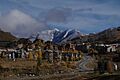
A view of the town of Mt. Crested Butte.

See also
 In Spanish: Mount Crested Butte para niños
