Sherrelwood, Colorado facts for kids
Quick facts for kids
Sherrelwood, Colorado
|
|
|---|---|

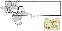
Location of the Sherrelwood CDP in Adams County, Colorado.
|
|
| Country | United States |
| State | Colorado |
| County | Adams |
| Government | |
| • Type | unincorporated community |
| Area | |
| • CDP | 2.454 sq mi (6.356 km2) |
| • Land | 2.453 sq mi (6.353 km2) |
| • Water | 0.010 sq mi (0.027 km2) |
| Elevation | 5,292 ft (1,613 m) |
| Population
(2020)
|
|
| • CDP | 19,228 |
| • Density | 7,880.3/sq mi (3,042.6/km2) |
| Time zone | UTC–7 (Mountain (MST)) |
| • Summer (DST) | UTC–6 (MDT) |
| ZIP Code |
80221
|
| Area code(s) | 303 and 720 |
| FIPS code | 08-69810 |
| GNIS feature ID | 2408726 |
Sherrelwood is a community in Adams County, Colorado, United States. It is not a city with its own government. Instead, it is called an unincorporated community. It is also a census-designated place (CDP). This means the United States Census Bureau counts its population for statistics.
Sherrelwood is part of a larger area called the Denver–Aurora–Lakewood, CO Metropolitan Statistical Area. In 2020, about 19,228 people lived there.
Contents
About Sherrelwood's Location
Sherrelwood is located in the state of Colorado. It is part of Adams County. The community is near the city of Denver.
Land and Water Area
The United States Census Bureau measures the size of places like Sherrelwood. The total area of Sherrelwood is about 2.454 square miles (6.356 square kilometers). Most of this area is land. Only a very small part, about 0.010 square miles (0.027 square kilometers), is water.
Population Over Time
The population of Sherrelwood has changed over the years. The United States Census Bureau has been counting the people in Sherrelwood since 1970.
| Historical population | |||
|---|---|---|---|
| Census | Pop. | %± | |
| 1970 | 18,868 | — | |
| 1980 | 17,629 | −6.6% | |
| 1990 | 16,636 | −5.6% | |
| 2000 | 17,657 | 6.1% | |
| 2010 | 18,287 | 3.6% | |
| 2020 | 19,228 | 5.1% | |
| U.S. Decennial Census 2020 Census |
|||
Population in 2020
In the 2020 United States census, 19,228 people lived in Sherrelwood. There were 6,147 households, which are groups of people living together. About 4,395 of these were families. The population density was about 7,880 people per square mile (3,042 people per square kilometer). There were also 6,324 housing units, which are places where people can live.
Population in 2010
In the 2010 United States census, there were 18,287 people living in Sherrelwood. At that time, there were 5,898 households and 4,328 families. The population density was about 7,530 people per square mile (2,907 people per square kilometer). There were 6,240 housing units.
Education in Sherrelwood
Students in Sherrelwood attend schools managed by the Westminster Public Schools district.
- Sherrelwood Elementary School is one of the schools in the area.
See also
 In Spanish: Sherrelwood (Colorado) para niños
 | Frances Mary Albrier |
 | Whitney Young |
 | Muhammad Ali |

