
Arvada, Colorado facts for kids
Quick facts for kids
Arvada, Colorado
|
||
|---|---|---|

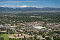
Aerial image of Arvada
|
||
|
||

|
||

Arvada, Colorado
Location in the United States

Arvada, Colorado
Location in Colorado
|
||
| Country | ||
| State | ||
| County | Jefferson and Adams | |
| Settled | 1859 | |
| Platted | December 1, 1870 | |
| Incorporated | August 24, 1904 | |
| Named for | Hiram Arvada Haskin | |
| Government | ||
| • Type | Home Rule City | |
| Area | ||
| • Total | 39.570 sq mi (102.485 km2) | |
| • Land | 38.910 sq mi (100.776 km2) | |
| • Water | 0.660 sq mi (1.709 km2) | |
| Elevation | 5,348 ft (1,630 m) | |
| Population
(2020)
|
||
| • Total | 124,402 | |
| • Rank | 7th in Colorado 229th in the United States |
|
| • Density | 3,197/sq mi (1,234/km2) | |
| • Metro | 2,963,821 (19th) | |
| • CSA | 3,623,560 (17th) | |
| • Front Range | 5,055,344 | |
| Demonym(s) | Arvadan | |
| Time zone | UTC−07:00 (MST) | |
| • Summer (DST) | UTC−06:00 (MDT) | |
| ZIP codes |
80001-80007 and 80403
|
|
| Area codes | 303/720/983 | |
| FIPS code | 08-03455 | |
| GNIS feature ID | 204709 | |
| GNIS City ID | 2409737 | |

Arvada is a city in Colorado, United States. It is located in Jefferson and Adams counties. In 2020, about 124,402 people lived there. This makes Arvada the seventh largest city in Colorado. It is part of the larger Denver–Aurora–Lakewood, CO Metropolitan Statistical Area. The historic area called Olde Town Arvada is about 7 miles (11 km) northwest of Denver.
Contents
History of Arvada
The first time gold was found in the Rocky Mountains was on June 22, 1850. A prospector named Lewis Ralston found a small amount of gold in a stream. This stream is now called Ralston Creek and is in Arvada's Gold Strike Park.
In 1858, Ralston came back with more gold seekers. Some of them stayed to farm the land along Ralston Creek. They grew crops to sell to other gold miners. The Territory of Colorado was created in 1861. The farms in the valley grew to feed the increasing population.
In 1870, the Colorado Central Railroad built tracks through the area. Benjamin F. Wadsworth and Louis A. Reno planned a townsite along the railroad. They named it Ralston Point. To avoid confusion, it was soon renamed Arvada. The name Arvada honors Hiram Arvada Haskin. He was the brother-in-law of settler Mary Wadsworth. The Arvada post office opened in 1871. Colorado became a state in 1876. The Town of Arvada officially became a city on August 14, 1904. Arvada was once famous for its celery farms. It was even called the "Celery Capital of the World."
Arvada grew quickly in the late 1900s. It became a suburb of nearby Denver. By the year 2000, Arvada's population was over 100,000 people.
Geography and Climate
In 2020, Arvada covered about 39.5 square miles (102.5 square kilometers). A small part of this area is water.
Climate in Arvada
Arvada has a humid continental climate. This means it has warm summers and cold winters.
| Climate data for Arvada, Colorado | |||||||||||||
|---|---|---|---|---|---|---|---|---|---|---|---|---|---|
| Month | Jan | Feb | Mar | Apr | May | Jun | Jul | Aug | Sep | Oct | Nov | Dec | Year |
| Mean daily maximum °F (°C) | 45 (7) |
48 (9) |
54 (12) |
63 (17) |
72 (22) |
83 (28) |
88 (31) |
87 (31) |
79 (26) |
67 (19) |
55 (13) |
46 (8) |
66 (19) |
| Mean daily minimum °F (°C) | 16 (−9) |
19 (−7) |
25 (−4) |
33 (1) |
41 (5) |
50 (10) |
56 (13) |
55 (13) |
45 (7) |
35 (2) |
25 (−4) |
18 (−8) |
35 (2) |
| Average precipitation inches (mm) | 0.5 (13) |
0.7 (18) |
1.2 (30) |
2 (51) |
2.4 (61) |
1.4 (36) |
1.6 (41) |
1.7 (43) |
1.2 (30) |
1.2 (30) |
0.8 (20) |
0.6 (15) |
15.6 (400) |
| Source: Weatherbase | |||||||||||||
Population Information
| Historical population | |||
|---|---|---|---|
| Census | Pop. | %± | |
| 1910 | 840 | — | |
| 1920 | 915 | 8.9% | |
| 1930 | 1,276 | 39.5% | |
| 1940 | 1,482 | 16.1% | |
| 1950 | 2,359 | 59.2% | |
| 1960 | 19,242 | 715.7% | |
| 1970 | 49,844 | 159.0% | |
| 1980 | 84,576 | 69.7% | |
| 1990 | 89,235 | 5.5% | |
| 2000 | 102,153 | 14.5% | |
| 2010 | 106,433 | 4.2% | |
| 2020 | 124,402 | 16.9% | |
| U.S. Decennial Census | |||

A census counts the number of people living in an area. In 2020, Arvada had 124,402 people. In 2010, there were 106,433 people living in the city. The city had 42,701 households. About 31.9% of these households had children under 18. The average household had 2.48 people.
The population's ages were spread out. About 23.4% of the people were under 18 years old. The median age was 40.5 years. This means half the people were younger than 40.5 and half were older. There were slightly more females than males.
Racial and Ethnic Groups (2020 Census)
| Race / Ethnicity (NH = Non-Hispanic) | Pop 2000 | Pop 2010 | Pop 2020 | % 2000 | % 2010 | % 2020 |
|---|---|---|---|---|---|---|
| White alone (NH) | 87,302 | 86,556 | 94,989 | 85.46% | 81.32% | 76.36% |
| Black or African American alone (NH) | 628 | 841 | 1,183 | 0.61% | 0.79% | 0.95% |
| Native American or Alaska Native alone (NH) | 419 | 437 | 550 | 0.41% | 0.41% | 0.44% |
| Asian alone (NH) | 2,175 | 2,225 | 3,096 | 2.13% | 2.09% | 2.49% |
| Pacific Islander alone (NH) | 47 | 58 | 72 | 0.05% | 0.05% | 0.06% |
| Some Other Race alone (NH) | 87 | 110 | 486 | 0.09% | 0.10% | 0.39% |
| Mixed Race or Multi-Racial (NH) | 1,464 | 1,670 | 5,390 | 1.43% | 1.57% | 4.33% |
| Hispanic or Latino (any race) | 10,031 | 14,536 | 18,636 | 9.82% | 13.66% | 14.98% |
| Total | 102,153 | 106,433 | 124,402 | 100.00% | 100.00% | 100.00% |
Economy and Jobs

Arvada is mostly a "commuter town." This means many people who live in Arvada travel to work in nearby cities like Denver and Boulder. The main shopping areas are along Wadsworth Boulevard, 52nd Avenue, 64th Avenue, Ralston Road, and Kipling Street.
Past Industry
From 1952 to 1992, a factory called the Rocky Flats Plant operated near Arvada. This factory made parts for nuclear weapons.
Education
Students in Arvada attend schools in the Jefferson County School District R-1.
Things to Do
Arvada has many fun places to visit and things to do:
- Arvada Center for the Arts and Humanities: A place for art, music, and theater.
- Cussler Museum: A museum with a collection of rare cars.
- Olde Town Arvada: A historic area with shops, restaurants, and events.
- Rocky Flats National Wildlife Refuge: A natural area for wildlife and outdoor activities.
- Two Ponds National Wildlife Refuge: Another natural area for wildlife.
Getting Around Arvada
Roads
Interstate 76 starts in Arvada. Other state highways like SH 72, SH 93, and SH 95 also pass through the city. Larger highways like Interstate 25 and U.S. Highway 36 are close by.
Public Transportation
The Amtrak California Zephyr train goes through Arvada. It travels between Chicago and Emeryville, California, near Oakland.
Arvada also has public transportation provided by the Regional Transportation District. This includes the G Line commuter train and several bus routes.
Airports
For air travel, people in Arvada use Denver International Airport. There is also a smaller airport nearby called Rocky Mountain Metropolitan Airport.
Biking
Arvada is a great place for biking. In 2014, the League of American Bicyclists recognized Arvada as a "Silver Level Bicycle Friendly Community."
Famous People from Arvada
Many well-known people have lived in Arvada. These include:
- Clive Cussler: A famous novelist.
- Roy Halladay: A professional baseball pitcher.
- Joe King and Isaac Slade: Members of the rock band The Fray.
- Nicholas Alexander Chavez: An actor.
- Babe Didrikson Zaharias: A professional golfer and Olympic gold medalist in track and field.
Sister Cities
Arvada has special connections with cities in other countries. These are called "sister cities":
 Jinzhou, China
 Kyzylorda, Kazakhstan
See also
 In Spanish: Arvada (Colorado) para niños
Images for kids
-
Aerial image of Arvada
-
Flag of Arvada, Colorado
-
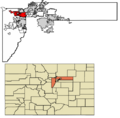
Location of the City of Arvada in Jefferson and Adams counties, Colorado.
