
Colorado Territory facts for kids
Quick facts for kids Territory of Colorado |
|||||||||||||||
|---|---|---|---|---|---|---|---|---|---|---|---|---|---|---|---|
| Organized incorporated territory of the United States | |||||||||||||||
| 1861–1876 | |||||||||||||||
.jpg) Coat of arms
|
|||||||||||||||
 The Colorado Territory as drawn in 1860 from the Utah, Nebraska, Kansas, and New Mexico Territories. Colorado appears to have a rectangular border at this scale, but there are in fact some slight deviations from a straight line along its southern border. |
|||||||||||||||
| Capital | Colorado City (1861–1862) Golden City (1862–1867) Denver City (1867–1876) |
||||||||||||||
| • Type | Organized incorporated territory | ||||||||||||||
| History | |||||||||||||||
| 28 February 1861 | |||||||||||||||
| 1 August 1876 | |||||||||||||||
|
|||||||||||||||
The Territory of Colorado was a special area of the United States that existed from February 28, 1861, until August 1, 1876. On that date, it officially became the State of Colorado.
This territory was created because of the Pike's Peak Gold Rush (1858–1861). This gold rush brought many new settlers to the region. The U.S. Congress passed a law to create the territory, and President James Buchanan signed it on February 28, 1861. This happened just before the American Civil War began.
The borders of the Colorado Territory were exactly the same as the borders of today's State of Colorado. Creating the territory helped the Union (the northern states during the Civil War) control a valuable area in the Rocky Mountains that had many minerals.
People thought Colorado would become a state very quickly. However, President Andrew Johnson stopped it in 1865. Becoming a state was discussed many times during President Ulysses S. Grant's time in office. Grant wanted Colorado to be a state, but Congress was not ready. The Colorado Territory stopped existing when Colorado became a state in 1876.
The new territory included parts of several other territories. East of the Continental Divide, it took land from the Kansas Territory, Nebraska Territory, and New Mexico Territory. West of the divide, it included a large part of the Utah Territory.
Many Native American groups lived in these areas. The Ute and Shoshoni people strongly controlled the western side. The Cheyenne and Arapaho lived on the Eastern Plains, along with the Pawnee, Comanche, and Kiowa.
In 1861, the Arapaho and Cheyenne agreed to give up most of their plains land to settlers. But they were allowed to live in their traditional areas. By the end of the Civil War in 1865, most Native Americans had left the High Plains.
Colorado's Past: A Look Back
| Historical population | ||
|---|---|---|
| Year | Pop. | ±% |
| 1860 | 34,277 | — |
| 1870 | 39,864 | +16.3% |
| Source: 1860–1870; | ||
The land that became the Colorado Territory joined the United States in three steps. First, through the Louisiana Purchase in 1803. Second, with the Annexation of Texas in 1845. And third, after the Mexican–American War in 1848, with the Mexican Cession. The borders of Texas were set by Congress in 1850.
Native American Communities in Colorado
Before European explorers arrived, different Native American groups lived in the Colorado area. The Ute lived across Western Colorado and onto the eastern plains. The Anasazi lived in the southwestern and southern parts.
The Comanche and Jicarilla Apache also controlled parts of the southeastern state. The Arapaho and Cheyenne hunted and lived in the eastern and northeastern plains.
Early Explorers and Settlers
The first European explorers to visit the area were from Spain. Coronado explored nearby lands in 1540–42. In 1776, Francisco Atanasio Domínguez and Silvestre Vélez de Escalante explored southern Colorado.
Other important explorations included:
- The Pike Expedition by Zebulon Pike in 1806–07.
- Stephen H. Long's journey along the Platte River in 1820.
- The John C. Frémont expedition in 1845–46.
- The Powell Geographic Expedition of 1869 by John Wesley Powell.
In 1779, Governor de Anza of New Mexico fought the Comanches in eastern Colorado. Later, in 1786, he made peace with them.
Gold Rush and New Towns
In 1848, a group of Cherokee people traveled through Colorado on their way to the California Gold Rush. They found small amounts of gold in the South Platte River. In the early 1800s, fur traders visited the area, but no one settled there permanently.
The first U.S. settlers arrived after 1854. Among them were former fur traders like Antoine Janis. He helped start a town near Laporte in 1858.
In 1858, Green Russell and his group from Georgia came looking for gold. They started a mining camp called Auraria. William Larimer, Jr., a land speculator, heard about the gold. He quickly claimed land across from Auraria and named it "Denver City" after the governor of Kansas Territory. Larimer wanted to sell land to miners, not mine gold himself.
Larimer's plan worked. By the next spring, many miners came to the South Platte area. This was called the Colorado Gold Rush. Miners moved into the mountains and founded camps like Black Hawk and Central City. Another town, Golden, was started to supply the miners.
Becoming a Territory
People in Denver and Golden quickly wanted their region to become a territory. William Byers, who published the Rocky Mountain News, and Larimer supported this idea. In 1859, settlers even tried to create their own "Territory of Jefferson," but the U.S. Congress did not recognize it.
Congress delayed making Colorado a territory because of disagreements over slavery. This changed when the Civil War began. In early 1861, many senators from southern states left Congress. This gave control to the Republicans, who supported creating new territories. Three new territories were created in just three days: Colorado (February 28), Nevada (March 1), and Dakota (March 2).
The Colorado Territory was officially created on February 28, 1861 (12 Stat. 172). It was formed from parts of the Kansas, Nebraska, Utah, and New Mexico territories. The name "Colorado" was chosen for the territory.
At first, Colorado City was the capital, but it was soon changed to Golden. Eventually, Denver became the temporary capital. Denver was made the permanent capital in 1881, five years after Colorado became a state.
Colorado During the Civil War
During the Civil War, fewer new miners came to Colorado. Many left to fight in the war. The Coloradans who stayed formed volunteer regiments.
In 1862, Confederate soldiers from Texas invaded the New Mexico Territory. Their plan was to move north into Colorado. But Colorado soldiers, led by Union Army officers like Edward Canby and John P. Slough, stopped them. They defeated the Confederates at the Battle of Glorieta Pass. This battle prevented the Confederates from cutting off supply lines to the Union.
The Colorado War: Conflict with Native Americans
In 1851, the Treaty of Fort Laramie promised the Cheyenne and Arapaho tribes control of the Eastern Plains in Colorado. This land was between the North Platte River and Arkansas River. The treaty allowed U.S. citizens to travel through these lands.
By the 1860s, the Colorado Gold Rush brought many settlers. They moved onto Native American lands. This caused problems between U.S. settlers and Native American people.
On February 18, 1861, some Cheyenne and Arapaho chiefs signed the Treaty of Fort Wise. They agreed to give up most of their lands for white settlement. They kept only a small area near the Arkansas River and Sand Creek. The U.S. wanted the tribes to become farmers on this new land.
However, many Cheyenne and Arapaho did not agree with this treaty. They said the chiefs did not have the right to sign it. Tensions grew. In 1862, Colorado's governor, John Evans, created a local military group. He took a strong stand against Native Americans accused of theft.
In November 1864, a group of Colorado soldiers attacked a Cheyenne and Arapaho camp at Sand Creek. This event is known as the Sand Creek Massacre. Many Native Americans, including elderly men, women, and children, were killed.
The U.S. Congress investigated the massacre. In their report, they strongly criticized the actions of Colonel John Chivington and his soldiers. They called their actions "foul, dastardly, brutal, cowardly."
It is difficult to believe that beings in the form of men, and disgracing the uniform of United States soldiers and officers, could commit or countenance the commission of such acts of cruelty and barbarity as are detailed in the testimony, but which your committee will not specify in their report.
Even though the actions were condemned, those responsible were not punished. The conflict continued, and eventually, the last Arapaho, Cheyenne, Kiowa, and Comanche people were moved from Colorado Territory to Oklahoma.
The Path to Statehood
After the Civil War, there was a push for Colorado to become a state. Congress passed a law for statehood in 1865, but President Andrew Johnson stopped it. For the next eleven years, statehood was delayed.
President Grant supported statehood in 1870, but Congress did not act. Meanwhile, Denver faced a challenge: a lack of railroads. Many people moved to towns like Laramie and Cheyenne in the Dakota Territory. These towns were on the main transcontinental railroad line.
To save Denver, its citizens raised money to build the Denver Pacific Railroad north to Cheyenne. This connected Denver to the main rail network. The Kansas Pacific Railway also reached Denver soon after. These railroads helped Denver become an important city in the region. Finally, the territory was admitted to the Union as a state in 1876.
Territorial Capitals
Three early Colorado communities served as the capital of Colorado Territory:
- Colorado City (1861–63)
- Golden City (1863–69)
- Denver City (1869–76)
Government Buildings
For most of its existence, the Colorado Territorial government did not own its buildings. Instead, it rented available spaces. Today, two buildings that served the Territorial government still exist: a historic log building in Colorado City, and the Loveland Block in Golden. The Loveland Block housed the legislature and library from 1866–67.
Other buildings that served the government included the original Loveland Building (housing the Territorial House from 1862–66) and the Overland Hotel (housing the Territorial Council from 1862–66).
Images for kids
-
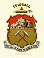
Colorado's state coat of arms, adopted in 1876.
-
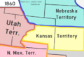
A map showing the Colorado Territory in 1860.
See also
 In Spanish: Territorio de Colorado para niños
