
Historical regions of the United States facts for kids
The United States has grown a lot over time. From when it was just a few colonies to the big country it is today, its land has changed quite a bit! This includes lands bought from other countries, lands given up by states, and even places that tried to become their own countries.

If you want to see a full list of how the U.S. is divided up today, check out List of regions of the United States.


Contents
- Colonial Times (Before 1776)
- Independent Lands That Joined the U.S.
- Lands Bought from Other Countries
- Lands Gained from or Given by Other Countries
- Lands Gained from Native American Nations
- Land Changes Between States and the Federal Government
- Former Organized Territories
- Internal Land Changes and Districts
- Military Districts and Departments
- Lands Returned or Given Up
- Unofficial Territories with Governments
- Regional Nicknames
- See also
Colonial Times (Before 1776)
Before the United States became its own country, many European nations had colonies here. These colonies often had different names and boundaries than our states today.


The Thirteen Colonies
These were the original British colonies that later formed the United States:
- Connecticut Colony
- Delaware Colony
- Province of Georgia
- Province of Maryland
- Province of Massachusetts Bay
- Province of New Hampshire
- Province of New Jersey
- Province of New York
- Province of North Carolina
- Province of Pennsylvania
- Colony of Rhode Island and Providence Plantations
- Province of South Carolina
- Colony and Dominion of Virginia
Regions Before the Revolutionary War
Some places were settled but didn't last, or were only ideas. The dagger (†) means it was a failed place or idea.
New England
- Acadia
- Dominion of New England†
- Equivalent Lands
- King's College Tract
- Provinces of Maine†
- Massachusetts Bay Colony
- New Hampshire Grants
- New Haven Colony
- Plymouth Colony
- Saybrook Colony
- Wessagusset Colony†
Mid-Atlantic
Southern
- Province of Carolina
- Fort Caroline†
- Charlesfort†
- La Florida
- San Agustín (St. Augustine)
- San Miguel de Gualdape† (in present-day South Carolina)
- Mocama Province†
- Jamestown
- Northern Neck Proprietary
- The Lost Colony of Roanoke†
- Stuarts Town†
Interior Lands

- District of West Augusta
- Illinois Country
- Indiana Company
- The Indian Reserve
- Ohio Country†
- Province of Quebec (the southern part, below the Great Lakes)
Far West
Most land west of the Mississippi River was ruled by France or Spain until the early 1800s.
- French Louisiana (1682–1762 and 1802–1803)
- Spanish Louisiana (1762–1802)
- Tejas
- Santa Fe de Nuevo México
- Las Californias
Colonies Settled but Not Recognized
These places had governments but were not officially recognized by larger powers.


Colonies Proposed but Never Built
These were ideas for colonies that never happened.
Independent Lands That Joined the U.S.
Some areas were independent countries before joining the United States.
- Kingdom of Hawaii, later the Republic of Hawaii
- Republic of Texas
- Vermont Republic (also called the Republic of New Connecticut)
Lands Bought from Other Countries
The U.S. bought large amounts of land from other nations.
- Louisiana Purchase, 1803, from France, for $15,000,000.
- Florida Purchase (or the Spanish Cession), 1819 (became official in 1821), from Spain, for $5,000,000. This included East Florida, West Florida, and the Sabine Free State.
- Gadsden Purchase, 1853, from Mexico, for $10,000,000.
- Alaska Purchase (also called "Seward's Folly"), 1867, from Russia, for $7,200,000.
- Virgin Islands, 1917, from Denmark, for $25,000,000.
Lands Gained from or Given by Other Countries
The U.S. also gained land through treaties or by taking it.
- American Samoa; 1899, from Germany.
- The Aroostook War Compromise Lands; 1842, shared disputed areas with the U.K..
- Maine–New Brunswick Border
- Northwest Angle
- Rupert's Land south of the 49th parallel.
- Guam; 1898, from Spain.
- Mexican Cession; became official in 1848, from Mexico. This included:
- Alta California (California, Nevada, Utah).
- Nuevo México (New Mexico, Arizona, parts of Texas, Colorado, Oklahoma, Wyoming, Kansas).
- Oregon Country (U.S.); the 1846 Oregon Treaty finally split the shared region between the U.S. and the United Kingdom at the 49th parallel.
- Pembina Region, once part of Rupert's Land and the Red River Colony; given to the U.S. in 1818.
- The Philippine Islands; 1898, from Spain. It was a U.S. Territory (1900–1935) and then a commonwealth (1935–1946).
- Puerto Rico; 1898, from Spain.
- Texas annexation; joined the U.S. in 1846 from Mexico. This included most of present-day Texas and parts of Oklahoma, Colorado, Wyoming, and No Man's Land. Mexico disputed this until 1848.
- This included old Coahuila y Tejas areas.
- Republic of West Florida Annexation; broke away from Spain in 1810. The U.S. disputed this with Spain until 1821.
- Baton Rouge District (annexed by the U.S., 1810).
- Mobile District (annexed by the U.S., 1812).
- United States Minor Outlying Islands; most were claimed under the Guano Islands Act (1856 and later).
- Some historic and current U.S. territories
-
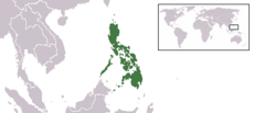
The Philippines was a commonwealth of the United States from 1935–1946.
-
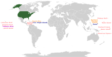
This map shows where current U.S. insular areas are located around the world.
-
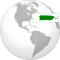
The Commonwealth of Puerto Rico.


.png)
Lands Gained from Native American Nations


The U.S. also gained land from Native American nations through purchases or treaties.
- Black Hawk Purchase; $640,000; purchased 1832; in Michigan Territory (which later became Iowa).
- Cherokee Outlet; $7,000,000; purchased 1893; in Oklahoma Territory (which later became Oklahoma).
- Cherokee Strip; a disputed two-mile wide area between the Cherokee Nation and Kansas. It was given to Kansas in 1866.
- Jackson Purchase; $300,000; purchased by Tennessee and Kentucky from the Chickasaw Nation in 1818.
- Lovely's Purchase; 1816 land purchase from the Osage Nation.
- Platte Purchase; $7,500; purchased 1836; in Missouri.
- Saginaw Cession; given up in 1819; in Michigan Territory (which later became Michigan).
Land Changes Between States and the Federal Government

States also gave up land to the federal government or settled border disputes with other states.
- The Delaware Wedge, a border dispute with Pennsylvania that was settled in 1921.
- Washington, D.C.; given to the Federal Government by Virginia and Maryland in 1790.
- District of Columbia retrocession; in 1847, the land Virginia had given for Washington D.C. was returned to Virginia.
- Greer County, Texas; a disputed county claimed by both Texas and the Federal Government. It went to Oklahoma Territory in 1896.
- The Honey Lands; a disputed area between the Territory of Iowa and State of Missouri. It went to State of Iowa in 1851.
- District of Kentucky; from Virginia; became the Commonwealth of Kentucky in 1792.
- Illinois County; from Virginia; became the Northwest Territory in 1784.
- District of Maine; from Massachusetts; became the State of Maine in 1820.
- The Toledo Strip; the cause of the nearly bloodless Toledo War between Ohio and Michigan. It went to Ohio in 1837.
- Washington District; from North Carolina; became the Southwest Territory in 1790.
- West Virginia; separated from Virginia during the Civil War in 1861; joined the U.S. in 1863.
- The Western Reserve; from Connecticut to the Northwest Territory (Ohio) in 1800.
- The Yazoo lands; from Georgia to the Mississippi Territory in 1802.
Former Organized Territories
.svg)


Here are 31 U.S. territories that later became states, listed by when they were organized.
- Northwest Territory (1787–1803), became Ohio and the Indiana Territory.
- Territory South of the River Ohio (also Southwest Territory) (1790–1796) became Tennessee.
- Territory of Mississippi (1798–1817) became Mississippi and the Alabama Territory.
- Territory of Indiana (1800–1816) split into the Illinois Territory, Michigan Territory, and Indiana.
- Territory of Orleans (1804–1812) became Louisiana.
- Territory of Michigan (1805–1837) became Michigan and the Wisconsin Territory.
- Territory of Louisiana (1805–1812) (before that, the District of Louisiana), then renamed the Missouri Territory.
- Territory of Illinois (1809–1818) split into Illinois and parts added to the Michigan Territory.
- Territory of Missouri (1812–1821) became Missouri and Unorganized Territory.
- Territory of Alabama (1817–1819) became Alabama.
- Territory of Arkansaw (1819–1836) became Arkansas, and parts of the unorganized Indian Territory.
- Territory of Florida (1822–1845) became Florida.
- Territory of Wisconsin (1836–1848) split into Wisconsin, the Iowa Territory, and Unorganized Territory.
- Territory of Iowa (1838–1846) split into Iowa and unorganized territory.
- Territory of Oregon (1848–1859) was previously the unrecognized Oregon Country. It split into Oregon and Washington Territory.
- Territory of Minnesota (1849–1858) became Minnesota and unorganized territory.
- Territory of New Mexico (1850–1912) was previously Nuevo Mexico. It split into the Arizona Territory and New Mexico.
- Territory of Utah (1850–1896) was previously Alta California and the unrecognized State of Deseret. It split into Utah, the Nevada Territory, and parts of the Colorado and Wyoming Territories.
- Territory of Washington (1853–1889) became Washington and parts of the Idaho Territory.
- Territory of Kansas (1854–1861) became Kansas. The western part became part of the Colorado Territory.
- Territory of Nebraska (1854–1867) split into Nebraska, the Dakota Territory, and parts of the Idaho and Colorado Territories.
- Territory of Colorado (1861–1876) became Colorado.
- Territory of Nevada (1861–1864) became Nevada.
- Territory of Dakota (1861–1889) became North Dakota, South Dakota, and parts of the Idaho and Wyoming Territories.
- Territory of Arizona (1863–1912) became Arizona and a part of Nevada.
- Territory of Idaho (1863–1890) became Idaho, the Montana Territory, and parts of the Dakota and Wyoming Territories.
- Territory of Montana (1864–1889) became Montana.
- Territory of Wyoming (1868–1890) became Wyoming.
- Territory of Oklahoma (1890–1907) was previously the unorganized Indian Territory. It became Oklahoma.
- Territory of Hawaii (1898–1959) was previously the Republic of Hawaii. It became Hawaii.
- Territory of Alaska (1912–1959) was previously the Department of Alaska and the District of Alaska. It became Alaska.
Internal Land Changes and Districts

These are land changes, districts, or settlements that happened within a U.S. state or territory. They didn't involve international treaties or Native American land purchases.
- Cumberland District, North Carolina (also District of Miro); in Tennessee.
- District of Louisiana; covered parts of Missouri, Kansas, Iowa, Nebraska, Minnesota, North and South Dakota, Montana, Arkansas, Oklahoma, Colorado, Wyoming; renamed Missouri Territory in 1812.
- Military Tract of 1812; in Illinois, Michigan, Arkansas, Missouri.
- Ohio Country; parts of Ohio, Indiana, Pennsylvania, West Virginia.
Alaska
- District of Alaska; renamed the Alaska Territory in 1912.
Colorado
- Pike's Peak Country
Iowa
Nebraska
New York

- Central New York Military Tract
- The Holland Purchase
- Macomb's Purchase
- Mill Yard Tract
- The Morris Reserve
- Phelps and Gorham Purchase
- The Triangle Tract
Ohio

- Canal Lands
- College Lands
- College Township
- Congress Lands (1798–1821)
- Congress Lands North of Old Seven Ranges
- Congress Lands West of Miami River
- Congress Lands East of Scioto River
- North and East of First Principal Meridian
- South and East of the First Principal Meridian
- Dohrman Tract
- Ephraim Kimberly Grant
- Firelands
- French Grant
- Indian Land Grants
- Maumee Road Lands
- Michigan meridian (also Toledo Tract)
- Miami & Erie Canal Lands
- Ministerial Lands
- Moravian Indian Grants
- Ohio & Erie Canal Lands
- The Ohio Company
- Donation Tract
- First Purchase
- Purchase on the Muskingum
- Refugee Tract
- Salt Reservations
- School Lands
- Seven Ranges
- Symmes Purchase
- Turnpike Lands
- Twelve Mile Square Reservation
- Two Mile Square Reservation
- United States Military District
- Virginia Military District
- Zane's Tracts
Oklahoma

- Big Pasture
- Indian Territory or The Oklahoma Indian Country
- Neutral Strip (or No Man's Land)
- Unassigned Lands
Indian Reserves
These are specific areas set aside for Native American tribes.
- The original and current Cherokee Nation
- Cheyenne–Arapaho Reserve
- Chickasaw Reserve
- Choctaw Reserve
- Comanche, Kiowa and Apache Reserve
- Creek Reserve
- Iowa Reserve
- Kaw Reserve
- Kickapoo Reserve
- Osage Reserve
- Ponca and Otoe–Missouria Reserve
- Citizen Potawatomi and Absentee Shawnee Reserve
- Sac and Fox Reserve
- Seminole Reserve
- Tonkawa Reserve
- Wichita and Caddo Reserve

Pennsylvania
Military Districts and Departments
These were areas controlled by the military, sometimes as the only government.
Central United States
- Department of the Northwest (1862–1865) covered Dakota, Minnesota, Montana, Wisconsin, Iowa, Nebraska.
- Department of the Missouri (1861–1865) covered Missouri, Arkansas, Illinois, part of Kentucky, and later Kansas.
- Department of New Mexico (1854–65) covered New Mexico Territory.
Pacific Area
- Pacific Division (1848–1853) covered lands gained in the Mexican–American War.
- Department of the Pacific (1853–1858; and 1861–1865).
- During the American Civil War, the Department of the Pacific had six smaller military districts:
- District of Oregon (1861–1865)
- District of California (1864–1865)
- District of Southern California (1861–1865)
- District of Humboldt (1861–1865)
- District of Utah (1862–1865)
- District of Arizona (1865)
- Department of California (1858–1861) covered California, Nevada, and southern Oregon Territory.
- Department of Oregon (1858–1861) covered Washington Territory and Oregon Territory.
- Military Division of the Pacific (1865–1891).
- Department of Alaska (1868–1884) later became the civilian-ruled District of Alaska.
- Department of Arizona (1865–1891) covered Arizona Territory.
- Department of the Columbia (1865–1891) covered Oregon, Washington Territory, part of Idaho Territory, and Alaska after 1870.
- District of Oregon (1865–1867) covered Washington Territory, Oregon Territory, and Idaho Territory.
- New Department of California (1865–1891) covered California, Nevada Territory, Arizona Territory, and part of New Mexico Territory.

The South
- Department of the Gulf (1862–1865; created during the Civil War) covered Mississippi, Alabama, Louisiana, and Texas.
- Trans-Mississippi (or Trans-Mississippi Department; CSA) (1862–1865). Covered Missouri, Arkansas, Texas, Indian Territory (now Oklahoma), Kansas, and Louisiana west of the Mississippi River.
The West
- Department of the West (1853–1861): covered all U.S. lands between the Mississippi River and the Pacific Military District.
Lands Returned or Given Up

The U.S. has also given back or transferred some lands.
- The Milk River and Poplar River lands given to the United Kingdom (Treaty of 1818).
- Commonwealth of the Philippines to Republic of the Philippines (1946).
- Chamizal, Texas, to Mexico (1964).
- Swan Islands to Honduras (1971).
- Rio Rico, Texas, (Horcón Tract) to Mexico (1977).
- Panama Canal Zone to Panama (1979).
- Canton and Enderbury Islands (shared with the U.K.) to Kiribati (1979).
Unofficial Territories with Governments

These "territories" had their own governments, even if they weren't officially recognized by the U.S. government.
- Cimarron Territory
- State of Deseret
- State of Frankland / Franklin
- Jefferson Territory
- Kansas Territory (1854–1861) had two different governments, one for slavery and one against it. Kansas joined the U.S. as a free state in 1861.
- Long Republic
- Nataqua Territory
- Trans-Oconee Republic
Civil War-Related Areas

These areas had their own governments because of the American Civil War (1861–1865). Some were small areas surrounded by enemy territory.
- Confederate States of America (CSA) – see map.
- Confederate Arizona (parts of the territories of Arizona and New Mexico)
- State of Dade
- Second Republic of South Carolina
These regions separated from their neighbors because they had different views during the war.
- Nickajack
- Free State of Jones
- Republic of Winston (see Winston County, Alabama)
- State of Scott, broke away from Tennessee and supported the Union (see Scott County, Tennessee)
- Town Line, New York
- Free State of Van Zandt, broke away from Texas to be its own republic.
Regional Nicknames

People often use nicknames to describe different parts of the U.S. These names usually come from geography, culture, or economy.
- Eastern United States
- The East Coast
- The Northeast
- South Atlantic States
- Appalachia
- East North Central States
- The South
- Border States
- The Deep South
- Dixie
- The Midwest
- The Great Plains
- The Dust Bowl
- The Great Plains
- The West
- Mountain States
- The Rockies
- Inland Empire (Washington and Idaho)
- Great Basin
- The Southwest
- The Four Corners
- The West Coast
- Mountain States
Belts
"Belts" are regions named for something they have in common, like their economy or climate.
- Bible Belt
- Black Belt
- Borscht Belt
- Breadbasket of the United States
- Cotton Belt
- Grain Belt or Corn Belt
- Mormon Corridor or "Jello Belt"
- Lead Belt
- Rust Belt
- Snow Belt
- Sun Belt
- Tornado Alley
See also
 In Spanish: Anexo:Regiones históricas de Estados Unidos para niños
- European colonization of the Americas
- List of former United States counties
- List of regions of the United States
- Political divisions of the United States
- Proposed states and territories of the United States
- Territorial evolution of the United States
- Territories of the United States on stamps
- United States territorial acquisitions
