Erie Triangle facts for kids
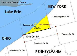
The Erie Triangle is a special piece of land in the United States. It's about 300 square miles (780 square kilometers) big. Many states argued over who owned this land a long time ago. Eventually, the U.S. government bought it. Then, they sold it to Pennsylvania. This gave Pennsylvania a way to reach Lake Erie and have a port for ships. Today, the Erie Triangle makes up a big part of Erie County, Pennsylvania.
Contents
How the Erie Triangle Came to Be
Most of northwestern Pennsylvania became part of the United States after a treaty in 1784. This was the Treaty of Fort Stanwix with the Iroquois Confederacy.
The Land Dispute
The next year, two states, New York and Pennsylvania, started arguing over their borders. Surveyors like Andrew Ellicott for Pennsylvania and James Clinton for New York helped map the area. They decided that New York's western border would be 20 miles (32 km) east of Presque Isle. Presque Isle is a small piece of land sticking out into Lake Erie near Erie, Pennsylvania.
But this mapping left an empty space. This unclaimed area became known as the Triangle Lands. It didn't belong to New York or Pennsylvania. Two other states, Connecticut and Massachusetts, also said they owned parts of it. Their claims came from old grants given to them when they were colonies.
Pennsylvania's Need for a Port
Out of these four states, only Pennsylvania was mostly landlocked. It had only a very small strip of coastline, about 3.75 miles (6 km) long. The new U.S. federal government stepped in to help.
All four states agreed to give up their claims to the federal government. Then, in 1792, the government sold the land to Pennsylvania. It was about 202,187 acres (81,818 hectares) and cost Pennsylvania $151,640.25. That was about 75 cents per acre.
Agreements with Native American Nations
The Six Nations of the Iroquois Confederacy also agreed to release the land to Pennsylvania. This happened in January 1789. Pennsylvania paid them $2,000, and the federal government paid $1,200.
The Seneca Nation made a separate agreement with Pennsylvania in February 1791. They received $800 for their land claims. This helped Pennsylvania gain full control of the Erie Triangle.
With this new land, Pennsylvania finally had good access to the Great Lakes. This was important for trade and travel.
Nickname and History
The Erie Triangle is often called a "tab" or "chimney" attached to Pennsylvania. This is because it sticks out from the rest of the state.
The waters off the coast of the Erie Triangle are sometimes called the Graveyard of Lake Erie. This is because many ships sank there in the 1700s and 1800s. The waters could be very stormy.
The area was also important during the War of 1812. A small battle happened there before the main Battle of Lake Erie. That bigger battle took place further west, near the Lake Erie Islands off the coast of Ohio.
 | Jewel Prestage |
 | Ella Baker |
 | Fannie Lou Hamer |


