Andrew Ellicott facts for kids
Quick facts for kids
Andrew Ellicott
|
|
|---|---|

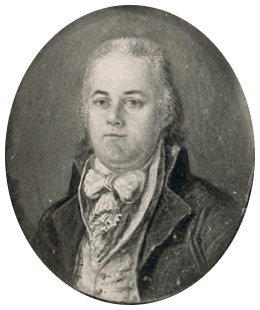
Andrew Ellicott in miniature portrait, 1799
|
|
| Born | January 24, 1754 Buckingham Township, Bucks County, Pennsylvania
|
| Died | August 28, 1820 (aged 66) |
| Occupation | Surveyor and town planner |
| Known for | Surveying many territories west of the Appalachians, the boundaries of the District of Columbia, and completing Pierre (Peter) Charles L'Enfant's plan for Washington |
| Spouse(s) | Sarah Brown |
Andrew Ellicott (born January 24, 1754 – died August 28, 1820) was an American land surveyor. He helped map many areas west of the Appalachian Mountains. He also surveyed the borders of District of Columbia.
Ellicott continued and finished the plan for Washington, D.C. that Pierre (Peter) Charles L'Enfant had started. He also taught survey methods to Meriwether Lewis, who later led the famous Lewis and Clark Expedition.
Contents
Early Life
Andrew Ellicott was born in Buckingham Township, Bucks County, Pennsylvania. He was the first of nine children. His parents were Joseph Ellicott and Judith Blaker.
His family were Quakers and lived simply. His father worked as a miller and clockmaker. Andrew went to a local Quaker school. There, Robert Patterson, who later became a professor, was one of his teachers. Andrew was good with machines and very talented in math.
In 1770, Andrew's father and uncles bought land near the Patapsco River in Maryland. They started a new milling business there. In 1772, they founded the town of Ellicott's Mills (now Ellicott City).
Three years later, Andrew married Sarah Brown. They had ten children together. When the Revolutionary War began in 1775, Andrew joined the Maryland state militia. Even though he was a Quaker, he became an officer. He rose to the rank of major, a title he used for the rest of his life.
Survey Work
After the war, Ellicott returned home. In 1784, he joined a team to extend the Mason-Dixon line. This line marked the borders between Pennsylvania, Delaware, and Maryland. He worked with important scientists like David Rittenhouse. This helped him connect with the scientific community in Philadelphia.
In 1785, the Ellicotts moved to Baltimore. Andrew taught math and was even elected to the Maryland General Assembly (state legislature). In 1786, he was asked to survey the western border of Pennsylvania with the Ohio Country. This "Ellicott Line" later became an important line for mapping the future Northwest Territory of the United States.
His work in Pennsylvania brought him closer to Benjamin Franklin. In 1789, his family moved to Philadelphia. President George Washington then asked Ellicott to survey the land between Lake Erie and Pennsylvania. This work helped define the border of the Erie Triangle. During this survey, he also mapped the Niagara River and Niagara Falls for the first time. This work made him known for his very accurate surveys.
Mapping Washington, D.C.

From 1791 to 1792, Ellicott worked for Secretary of State Thomas Jefferson. He helped survey the borders of the federal Territory of Columbia. This area later became Washington, D.C..
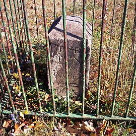
Ellicott's team placed forty boundary stones about 1 mile (2 km) apart. These stones marked the borders of the 100 square mile (260 km2) Territory of Columbia. Most of these stones are still in their original places today.
Ellicott also helped survey the future city of Washington. This city was located in the center of the Territory of Columbia, along the Potomac River. He first worked with Pierre (Peter) Charles L'Enfant, who had created the first plans for the capital city.
In February 1792, L'Enfant had not been able to print his city plan. He also refused to give Ellicott his original plan. So, Ellicott, with help from his brother Benjamin, revised the plan. Ellicott said he knew L'Enfant's system and had many of his own survey notes. This allowed him to recreate the plan.
Ellicott's changes made some streets straighter and added or removed some avenues and plazas. Because of disagreements, President Washington later removed L'Enfant from the project. Ellicott's revised plan was the first one widely printed and distributed. His changes became the basis for how Washington D.C. was built.
Other Important Surveys
In 1794, Ellicott was asked to plan the city of Erie on the shore of Lake Erie. This would give Pennsylvania a port on the Great Lakes. He spent two years on this task. He also oversaw the building of Fort Erie.
In 1796, President George Washington sent Ellicott to survey the southern border between the United States and Spanish territories in Florida. This was part of the Treaty of San Lorenzo (1795). Ellicott traveled with a military escort down the Ohio and Mississippi rivers. He worked with Spanish officials for four years, despite many challenges.
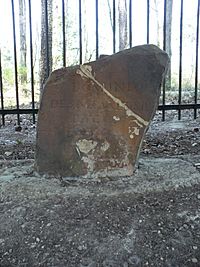
Another "Ellicott's Line" from this survey, along latitude 31° North, still marks the border between Alabama and Florida today. One of his stone markers, the Ellicott Stone, is now in a historical park in Bucks, Alabama.
In 1798, Ellicott reported to the government that some American generals were receiving money from Spain. He showed great skill in finishing this border project. He gave his final report and maps to the government in 1800.
However, the next president's administration refused to pay Ellicott for his work. They even kept his maps. He had to sell some of his belongings to support his family. In 1803, under President Jefferson, the maps were finally released. Ellicott then published his Journal of Andrew Ellicott, which described the Florida survey and included his maps.
Later Life and Teaching
President Jefferson offered Ellicott the job of Surveyor General of the Northwest Territory. But Ellicott turned it down. He wanted to spend more time with his family and felt the job would involve too much travel.

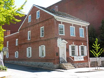
Instead, Ellicott accepted a job as Secretary of the Pennsylvania Land Office. His family moved to Lancaster, Pennsylvania. This job gave him a steady income and time for his own scientific interests. His house in Lancaster, where he lived from 1801 to 1813, is now a historic landmark.
In 1803, President Jefferson asked Ellicott to teach Meriwether Lewis. Lewis was preparing to lead the Lewis and Clark Expedition. From April to May 1803, Lewis stayed at Ellicott's home. He learned survey techniques, and Ellicott gave advice on equipment and procedures for the expedition. The two men got along well.
In 1809, Ellicott lost his job due to political differences. He returned to private work. In 1811, he was hired to re-survey the border between Georgia and North Carolina. This was to settle a border dispute. Ellicott found that the border was further south than Georgia claimed. Georgia's government was not happy and refused to pay him. Ellicott returned to Pennsylvania in 1812.
In 1813, Ellicott became a professor of mathematics at the United States Military Academy at West Point. His family moved to West Point, New York. In 1817, he took part in his last major survey, re-surveying the Collins–Valentine line. Andrew Ellicott died three years later from a stroke at his home in West Point.
In Memoriam
Andrew Ellicott Park in Arlington County, Falls Church, and Fairfax County in Northern Virginia honors Ellicott. It is located at the original west corner of the District of Columbia. Ellicott Circle and Ellicott Street in Washington, D.C. are also named after him.
See also
 In Spanish: Andrew Ellicott para niños
 | Georgia Louise Harris Brown |
 | Julian Abele |
 | Norma Merrick Sklarek |
 | William Sidney Pittman |


