Surveyor General of the Northwest Territory facts for kids
Quick facts for kids Surveyor General of the Northwest Territory |
|
|---|---|
| Constituting instrument | Land Act of 1796 |
| First holder | Rufus Putnam |
| Final holder | Lucius Lyon |
| Abolished | June 1845 |
| Succession | Commissioner of the General Land Office |
| Salary | $2,000 |
The Surveyor General of the Northwest Territory was an important government job in the early United States. This person was in charge of mapping and measuring land. Their work happened in the Northwest Territory during the late 1700s and early 1800s.
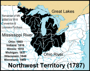
This job was created by a law called the Land Act of 1796. Its main purpose was to survey lands that were given up by Native Americans. These lands were located northwest of the Ohio River and above the Kentucky River. The work of the Surveyor General helped create the Public Land Survey System. This system is still used today to organize land in many parts of the U.S.
Contents
Who Were the Surveyors General?
Many different people held the job of Surveyor General. Each one played a part in mapping the growing United States.
Early Surveyors
Rufus Putnam was the first Surveyor General. He started in 1797 and worked until 1803. His office was in Marietta, Ohio.
In 1801, Thomas Jefferson offered the job to Andrew Ellicott. However, Ellicott said no. He was unhappy about not being paid quickly for past work.
Jared Mansfield took over the role from 1803 to 1813. His office was located in Cincinnati, Ohio.
Later Surveyors and Changes
After Mansfield, Josiah Meigs held the office from 1813 to 1815. Then, Edward Tiffin served from 1815 until he passed away in 1829. Tiffin's office was in Chillicothe, Ohio.
In 1816, a new Surveyor General office was created for Illinois. This meant the Northwest Territory Surveyor General's area became smaller. It then covered only Ohio, Indiana, and Michigan.
William Lytle was Surveyor General from 1829 until 1831. He moved the office back to Cincinnati. Micajah T. Williams held the job from 1831 to 1834. Then, Robert Todd Lytle took over.
Ezekiel S. Haines was appointed in 1838. Judge William Johnston served from 1841 to 1845. He was given the job for helping the Whig political party.
The last person to hold the position was Lucius Lyon, appointed in 1845. He moved the office to Detroit.
End of the Role
In June 1845, the offices for Ohio and Indiana were closed. After this, land surveys were handled by the Commissioner of the General Land Office. This meant the job of Surveyor General of the Northwest Territory no longer existed.
What Did They Do?
The Surveyor General and their team had a big job. They had to measure and map huge areas of land.
Early Tasks
In 1797, Rufus Putnam was busy mapping the Greenville Treaty Line. This line marked a boundary with Native American lands. He also surveyed special land areas like the United States Military District. In 1798, he began surveying "Congress Lands." These were lands the government planned to sell.
Setting Standards
Jared Mansfield was known for his scientific skills. He set high standards for surveying. He carefully mapped the Indiana baseline and the Second Principal Meridian. These were important starting points for all other surveys.
It was a tough job. The government wanted surveys done quickly and cheaply. Secretary of the Treasury Albert Gallatin once told Mansfield: "It is of primary importance that the land should be surveyed and subdivided." This meant getting the boundaries right was more important than exact acreage.
Edward Tiffin helped create a system of "guide meridians" and "standard parallels." These were like invisible grid lines. They helped surveyors map townships far from the main starting points. This system became a key part of the Public Land Survey System.
Expanding the Role
Over time, similar Surveyor General jobs were created for other parts of the country. For example, in 1803, a Surveyor General was appointed for lands south of Tennessee. In 1822, the state of Ohio became the first surveying district with its own Surveyor General.
Before 1836, each Surveyor General worked mostly on their own. They set their own rules for how to do the field work. After 1836, the General Land Office was reorganized. This brought more standard rules for surveying across the country.
 | John T. Biggers |
 | Thomas Blackshear |
 | Mark Bradford |
 | Beverly Buchanan |


