United States Military District facts for kids
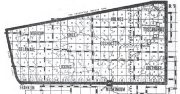
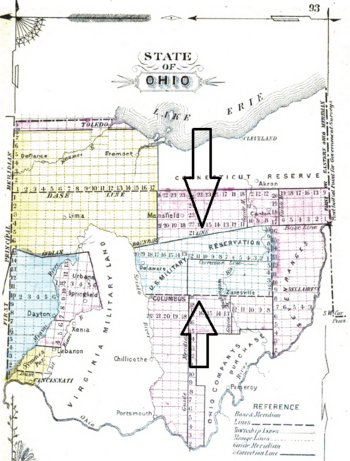
The United States Military District was a large area of land in central Ohio. It was created by the United States Congress to give land to soldiers who fought in the American Revolutionary War. This land covered about 2.5 million acres (10,275 square kilometers). It included parts of many counties in Ohio, such as Noble, Guernsey, Tuscarawas, Muskingum, Coshocton, Holmes, Licking, Knox, Franklin, Delaware, Morrow, and Marion counties.
Contents
History of the Land Grants
After the American Revolutionary War, the Congress didn't have much money to pay the soldiers who had fought for the country's freedom. To encourage people to join the army, they promised land instead of money.
Between 1776 and 1780, Congress passed several resolutions. These promised land to officers and soldiers who served continuously until the end of the war, or until they were discharged. If a soldier died fighting, their family would receive the land. The amount of land depended on their rank:
| Land Given (acres) |
Ranks |
|---|---|
| 1100 | Major General |
| 850 | Brigadier General, Director |
| 500 | Colonel, Chief Physician, Purveyor |
| 450 | Lieutenant Colonel, Physician, Surgeon, Apothecary |
| 400 | Major, Regimental Surgeon, Asst. Apothecary |
| 300 | Captain, Surgeons Mate |
| 200 | Lieutenant |
| 150 | Ensign |
| 100 | Non-commissioned officer, Soldier |
At first, land in the Seven Ranges area was set aside for these payments under the Land Ordinance of 1785. However, this wasn't enough land for all the veterans.
How the District Was Set Up
On June 1, 1796, Congress officially created the United States Military District. It was also known as the USMD Lands or USMD Survey. The boundaries of this district were carefully drawn. It started at the northwest corner of the Seven Ranges, then went south, then west to the Scioto River. From there, it followed the Scioto River north to the Greenville Treaty Line. Then it went northeast along that line to Fort Laurens, and finally back to the starting point.
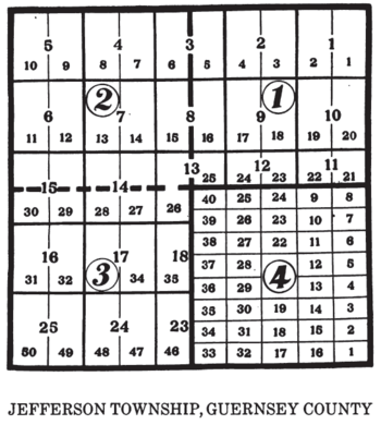
This large area covered 2,539,110 acres. Surveyors began mapping the land in March 1797. The land was divided into survey townships that were five miles (8 km) square. This was different from most other government surveys, which usually used six-mile (10 km) square townships. Each five-mile township was then divided into four smaller sections of 4,000 acres (16 square kilometers) each.
Later, in 1800, these smaller sections were further divided into lots of 100 acres (0.4 square kilometers) each. By 1803, any land that hadn't been claimed by veterans was divided into one-mile (1.6 km) square sections and half-sections. This land was then sold to the public through land offices in Chillicothe and Zanesville.
Land Claims and Sales
Many veterans who received land warrants (documents promising them land) didn't actually move to Ohio. Instead, they often sold their warrants to people called speculators or "jobbers" for a much lower price than the land was worth.
Out of the 1,043,460 acres claimed with land warrants, more than half (569,542 acres) ended up being owned by just 22 people! The exact location of the land for military warrants was chosen by a drawing. Many of these new owners never even visited their land. They bought and sold it as an investment, often without checking if there were any unpaid taxes on the land.
By 1823, the U.S. government had issued over 10,958 warrants for Revolutionary War service, totaling about 1.5 million acres. These warrants could mostly only be used in the USMD.
Eventually, veterans who still held onto their warrants got some help. A law in 1830 allowed them to exchange their warrants for "land scrip." This scrip was like a coupon, worth $1.25 per acre, and could be used to buy land anywhere else in the public domain. This meant veterans didn't have to use their land in the specific Ohio district. However, many veterans still sold their land scrip to land jobbers instead of using it themselves.
Special Land Areas Inside the District
Within the United States Military District, there were a few special land areas that were set up differently. These included the Moravian Indian Grants in Tuscarawas County, which were for the villages of Schoenbrunn, Gnaddenhutten, and Salem. These were 4,000-acre (16 square kilometer) surveys that didn't follow the same grid pattern as the rest of the USMD. Also, part of the "Muskingum River Survey" from Zane's Tracts was located within the USMD.
 | Stephanie Wilson |
 | Charles Bolden |
 | Ronald McNair |
 | Frederick D. Gregory |


