Marion County, Ohio facts for kids
Quick facts for kids
Marion County
|
|||
|---|---|---|---|

|
|||
|
|||

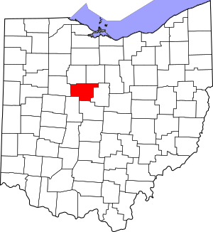
Location within the U.S. state of Ohio
|
|||
 Ohio's location within the U.S. |
|||
| Country | |||
| State | |||
| Founded | February 20, 1820 | ||
| Named for | Francis Marion | ||
| Seat | Marion | ||
| Largest city | Marion | ||
| Area | |||
| • Total | 404 sq mi (1,050 km2) | ||
| • Land | 404 sq mi (1,050 km2) | ||
| • Water | 0.4 sq mi (1 km2) 0.1%% | ||
| Population
(2020)
|
|||
| • Total | 65,359 |
||
| Time zone | UTC−5 (Eastern) | ||
| • Summer (DST) | UTC−4 (EDT) | ||
| Congressional district | 4th | ||
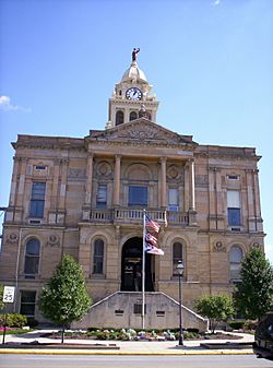
Marion County is a county found in the state of Ohio in the United States. In 2020, about 65,359 people lived here. The main city and government center of the county is Marion. This is called the county seat.
Marion County was created by Ohio on February 20, 1820. It was later set up again in 1824. The county is named after General Francis "Swamp Fox" Marion. He was a brave officer from South Carolina who fought in the Revolutionary War.
Contents
Exploring Marion County's Land
According to the U.S. Census Bureau, Marion County covers a total area of 404 square miles. Almost all of this area is land. Only a tiny part, about 0.4 square miles, is water. This makes it one of the smaller counties in Ohio.
Neighboring Counties
Marion County shares its borders with several other counties. These are its neighbors:
- Crawford County (to the northeast)
- Morrow County (to the east)
- Delaware County (to the south)
- Union County (to the southwest)
- Hardin County (to the west)
- Wyandot County (to the northwest)
Main Roads and Highways
Many important roads run through Marion County. These highways help people travel around the county and to other places:
 US 23
US 23 SR 4
SR 4 SR 37
SR 37 SR 47
SR 47 SR 95
SR 95 SR 98
SR 98 SR 100
 SR 203
 SR 231
 SR 309
 SR 423
 SR 529
 SR 739
 SR 746
People of Marion County
The number of people living in Marion County has changed over many years. Here is a look at the population from different census counts:
| Historical population | |||
|---|---|---|---|
| Census | Pop. | %± | |
| 1830 | 6,551 | — | |
| 1840 | 14,765 | 125.4% | |
| 1850 | 12,618 | −14.5% | |
| 1860 | 15,490 | 22.8% | |
| 1870 | 16,184 | 4.5% | |
| 1880 | 20,565 | 27.1% | |
| 1890 | 24,727 | 20.2% | |
| 1900 | 28,678 | 16.0% | |
| 1910 | 33,971 | 18.5% | |
| 1920 | 42,004 | 23.6% | |
| 1930 | 45,420 | 8.1% | |
| 1940 | 44,898 | −1.1% | |
| 1950 | 49,959 | 11.3% | |
| 1960 | 60,221 | 20.5% | |
| 1970 | 64,724 | 7.5% | |
| 1980 | 67,974 | 5.0% | |
| 1990 | 64,274 | −5.4% | |
| 2000 | 66,217 | 3.0% | |
| 2010 | 66,501 | 0.4% | |
| 2020 | 65,359 | −1.7% | |
| U.S. Decennial Census 1790-1960 1900-1990 1990-2000 2020 |
|||
What the 2010 Census Showed
In 2010, there were 66,501 people living in Marion County. There were 24,691 homes and 16,837 families. Most people in the county were white (91.1%). About 5.7% were black or African American. People of Hispanic or Latino background made up 2.3% of the population.
The average age of people in the county was about 39.9 years old.
Learning and Education
Colleges and Universities
Marion County has places for higher education. These include:
- Marion Technical College
- Ohio State University, Marion Campus
Public Schools
Most students in Marion County attend schools in five main districts:
- Elgin Local Schools
- Marion City School District
- Pleasant Local School District
- Ridgedale Local School District
- River Valley Local School District
Some smaller parts of the county are also served by other school districts. These include Buckeye Valley Local School District, Cardington-Lincoln Local Schools, Northmor Local School District, and Upper Sandusky Exempted Village School District.
Communities in Marion County
Cities
- Marion (This is the county seat, where the main county government is located.)
Villages
Smaller towns in Marion County are called villages. They include:
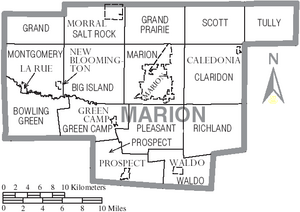
Townships
Townships are areas of land that often include smaller communities or rural areas. Marion County has several townships:
- Big Island
- Bowling Green
- Claridon
- Grand
- Grand Prairie
- Green Camp
- Marion
- Montgomery
- Pleasant
- Prospect
- Richland
- Salt Rock
- Scott
- Tully
- Waldo
Unincorporated Communities
These are smaller places that are not officially part of a city or village. They include:
- Bellaire Gardens
- Big Island
- Brush Ridge
- Centerville
- Claridon
- DeCliff
- Espyville
- Gast Corner
- Kirkpatrick
- Martel
- Meeker
- Owens
- Tobias
See also
 In Spanish: Condado de Marion (Ohio) para niños
 | Kyle Baker |
 | Joseph Yoakum |
 | Laura Wheeler Waring |
 | Henry Ossawa Tanner |


