
Union County, Ohio facts for kids
Quick facts for kids
Union County
|
|||
|---|---|---|---|

Union County Courthouse
|
|||
|
|||

Location within the U.S. state of Ohio
|
|||
 Ohio's location within the U.S. |
|||
| Country | |||
| State | |||
| Founded | April 1, 1820 | ||
| Named for | formed from the union of parts of surrounding counties | ||
| Seat | Marysville | ||
| Largest city | Marysville | ||
| Area | |||
| • Total | 437 sq mi (1,130 km2) | ||
| • Land | 432 sq mi (1,120 km2) | ||
| • Water | 5.1 sq mi (13 km2) 1.2%% | ||
| Population
(2020)
|
|||
| • Total | 62,784 | ||
| • Density | 143.67/sq mi (55.47/km2) | ||
| Time zone | UTC−5 (Eastern) | ||
| • Summer (DST) | UTC−4 (EDT) | ||
| Congressional district | 4th | ||


Union County is a county located in the state of Ohio. In 2020, about 62,784 people lived here. The main town, or county seat, is Marysville. The county got its name because it was formed from parts of several other counties, like Franklin, Delaware, Madison, and Logan counties.
Union County is also part of the larger Columbus, Ohio Metropolitan Statistical Area.
Contents
History of Union County
Early Days and Explorers
Union County has been part of three different countries. First, it was claimed by France. French explorers like Robert de La Salle visited the area with traders and missionaries.

After the French and Indian War, the Treaty of Paris of 1763 gave the land to England. Then, after the American Revolution in 1783, the area became part of the United States. It was known as the Northwest Territory.
After the American Revolution, many soldiers from New England moved to Ohio. The government gave them land there. They wanted to create a new state between Lake Erie and the Ohio River. Their ideas helped create the Ordinance of 1787. This law guided how new states would be formed in the Northwest Territory.
For many years, there were conflicts with American Indian tribes. These struggles ended with the Battle of Tippecanoe in 1811. This battle led to the defeat of American Indian tribes in Ohio, including those led by Tecumseh. A person named Jonathan Alder, who lived in the Union County area, was involved in these conflicts.
First Settlements and Towns
The very first town planned in the county was North Liberty in 1797. It was started by Lucas Sullivant. However, the first actual settlement was in what is now Jerome township in 1798. It was started by Joshua and James Ewing.
Another important settlement was made by Abraham Amrine in 1817. He was a soldier from the American Revolution and was of Swiss background. His settlement was about 2 miles (3.2 km) northwest of Marysville.
How Union County Was Formed
The United States made a deal with Virginia about land in Ohio. This land became known as the Virginia Military District. Union County was part of this district. In 1803, Ohio became an independent state.
A person named Colonel James Curry worked hard to make Union County an official county. He lived in what would become Jerome township. In 1820, the Ohio legislature officially created Union County. The first leaders, called commissioners, were Stephen Bell, Reuben Wallace, and John Huston.
These commissioners then created different townships. Some of the early ones included Union (1820), Darby (1820), Mill Creek (1820), and Jerome (1821). They also chose Marysville as the main town, or county seat.
Many towns were established over the years:
- Milford was started in 1816 by George Reed.
- Marysville was started in 1819 by Samuel Culbertson.
- Richwood was started in 1832 by Philip Plumber.
- Other towns like Kingsville (1834), Somerville (1835), and Magnetic Springs (1879) followed.
Marysville: The County Seat

After Union County was formed, Marysville was chosen as its county seat. The first meeting of the county leaders happened in 1820. A courthouse was built between 1835 and 1840. A new courthouse was built later and opened on January 27, 1883. This is the courthouse still used today.
In 1849, a county infirmary (a place for the poor or sick) was approved. The first county jail was a log building behind the courthouse. A new jail was built in the 1870s. In 1878, the county bought a large, heavy safe for its money.
The first county fair was held in Marysville in 1847. In 1852, the fair moved to its current location on the north side of town.
In 1866, the Union County Teachers' Institute was started in Marysville. It helped train teachers. In 1882, a Normal School was organized by J.S. Wharton. This school also focused on teaching future educators.
Growing the County: Infrastructure
Union County did not have good transportation at first. In 1812, the first main road, called Post Road, was built across the southern part of the county. In 1844, a free turnpike (a toll-free road) was created. It ran from Columbus to Bellefontaine and went through Marysville. This road is now known as U.S. Route 33.

By 1915, Union County had built 705 miles (1,135 km) of roads. This was more than any other county of its size in Ohio.
By the late 1800s and early 1900s, electricity started to come to the county. By 1915, power lines connected Magnetic Springs to Richwood.
The county's first railroad was built between 1850 and 1854. It connected Springfield to Delaware and passed through Milford, Marysville, Irwin, and Dover. Other railroads were built later, connecting more towns like Richwood, Peoria, and Raymond.
The first telegraph line was finished in 1859. This connected Marysville to the rest of the world through Springfield.
Farming and Business

Union County has very fertile soil, so farmers did not need much fertilizer. In the early days, there were hundreds of farms. Farmers grew crops like wheat, oats, corn, and potatoes. The county also produced a lot of milk, butter, sugar, apples, and pears.
In 1911, about 270,000 acres (1,100 km²) of land in Union County were owned. About 85,000 acres (340 km²) were used for farming. Farms had many animals, including over 9,000 horses, 8,000 milk cows, and 43,000 sheep. They produced a lot of wool.
Union County had many different businesses in its early days. These included hotels, tanneries (where leather is made), distilleries (where alcohol is made), mills (for grinding grain), and factories.

Marysville had important early industries. The Marysville Pearlash Factory, started in 1848, was the largest in the United States by 1874. It made a product used in soap and glass. Other businesses included flour mills, a butter tub company, and a wool company.
In 1868, O.M. Scotts and Company was started. This company later became the famous Scotts Miracle-Gro Company. Marysville also had many companies that made carriages.
Richwood had hotels and large mills. It also had tile factories and many shops. Milford Center had mills, distilleries, and companies that made lumber and carriages.

Magnetic Springs became a popular place for tourists. People believed its natural waters had healing powers. Tourists from all over the world visited the springs and stayed at resorts. This lasted until modern medicine became more common in the early 1900s.
Law and Politics
Union County was home to many important legal figures. John F. Kinney practiced law here in 1836 and later became a supreme court justice in Iowa. Edward Stillings grew up near Milford Center and became a top lawyer. He helped create the legal rules for Kansas in the 1870s.
James Wallace Robinson was from Union County and became a U.S. Congressman in 1872. James E. Robinson, also from Union County, later became an Ohio Supreme Court justice.

Charles W. Fairbanks started his law career here in 1874. He later became the Vice President of the United States.
Newspapers and Media

Newspapers were very important in shaping public opinion in the early days. The first known newspaper in Union County was the Our Freedom and Union County Advertiser, started in Marysville in 1839. It changed names several times, becoming the Union Star and then the Union Gazette.
Over the years, different people owned the newspaper, and its political views changed. In 1849, it was bought by C.S. Hamilton and renamed the Marysville Tribune. A notable person who worked there was Preston Plumb, who later became a U.S. Senator for Kansas. The Marysville Tribune eventually became a Republican-leaning newspaper.
Many other newspapers were started in the county, but most did not last long. In 1874, the Marysville Journal was formed. By 1883, only the Marysville Tribune and the Union County Journal were still being published. In 1952, these two newspapers merged to become the Marysville Journal-Tribune, which is still published today.
Banking and Money

In the early 1800s, most people in Union County were not wealthy. They often traded goods like animal skins, whiskey, or honey instead of using money. Early banks often failed.
As the county grew and became richer, money became more valuable. Banks were then permanently established. The first bank in Union County was the Bank of Marysville, started in 1854.
Modern Growth


Memorial Hospital of Union County was built in Marysville in 1952. Other new developments included the Union County Airport and many factories and housing areas. U.S. Route 33 was expanded from two lanes to four lanes in the 1980s.
Military History

Union County has a long military history. Many soldiers from the American Revolution moved to Union County because the government gave them land here. At least 14 Revolutionary War soldiers are known to have settled in the county.
During the War of 1812, a company of 13 men from Union County was formed. Many other local people joined military groups from outside the county. Over 100 people from Union County served in this war.
When the Mexican War started in 1845, Union County sent over 30 men to fight.

The American Civil War followed. Union County provided 3,200 men for this war. Notable leaders like Norton P. Chipman came from the county. He helped create Memorial Day.

In 2007, the Union County Veterans Memorial was dedicated in Marysville. It honors all veterans from the county. In 2008, the Ohio National Guard opened a new training center in Marysville.
Geography of Union County
Union County covers about 437 square miles (1,130 km²). Most of this is land, with about 5.1 square miles (13 km²) being water.
Neighboring Counties
Union County shares borders with these counties:
- Marion County (northeast)
- Delaware County (east)
- Franklin County (southeast)
- Madison County (south)
- Champaign County (southwest)
- Logan County (west)
- Hardin County (northwest)
Main Roads and Highways
Many important roads run through Union County:
 US 33
US 33 US 36
US 36 US 42
US 42 SR 4
SR 4 SR 31
SR 31 SR 37
SR 37 SR 38
SR 38 SR 47
SR 47 SR 161
 SR 245
 SR 347
 SR 736
 SR 739
People of Union County
| Historical population | |||
|---|---|---|---|
| Census | Pop. | %± | |
| 1820 | 1,996 | — | |
| 1830 | 3,192 | 59.9% | |
| 1840 | 8,422 | 163.8% | |
| 1850 | 12,204 | 44.9% | |
| 1860 | 16,507 | 35.3% | |
| 1870 | 18,730 | 13.5% | |
| 1880 | 22,375 | 19.5% | |
| 1890 | 22,860 | 2.2% | |
| 1900 | 22,342 | −2.3% | |
| 1910 | 21,871 | −2.1% | |
| 1920 | 20,918 | −4.4% | |
| 1930 | 19,192 | −8.3% | |
| 1940 | 20,012 | 4.3% | |
| 1950 | 20,687 | 3.4% | |
| 1960 | 22,853 | 10.5% | |
| 1970 | 23,786 | 4.1% | |
| 1980 | 29,536 | 24.2% | |
| 1990 | 31,969 | 8.2% | |
| 2000 | 40,909 | 28.0% | |
| 2010 | 52,300 | 27.8% | |
| 2020 | 62,784 | 20.0% | |
| U.S. Decennial Census 1790-1960 1900-1990 1990-2000 2020 |
|||
2010 Census Information
In 2010, Union County had 52,300 people living there. There were 18,065 households and 13,681 families. The county had about 121 people per square mile (46.7/km²).
Most people (92.9%) were white. There were also people of Asian (2.7%), black (2.4%), and American Indian (0.2%) backgrounds. About 1.3% of the population was Hispanic or Latino.
Many people had German (34.1%), Irish (15.3%), English (13.6%), or American (13.6%) ancestry.
About 40.8% of households had children under 18. Most households (62.8%) were married couples. The average age in the county was 36.4 years.
The average income for a household was $68,452. For families, it was $78,254. About 6.4% of the population lived below the poverty line.
Economy of Union County


The biggest industries in Union County are farming, manufacturing (making things in factories), and research and development. The sales tax in the county is 7.00%. Union County usually has low unemployment rates, which means many people have jobs.
Farming in the County
Farming is a big part of Union County's economy. Out of 277,760 acres (1,124 km²) in the county, 230,720 acres (934 km²) are used for farming. In 2006, there were 1,000 farms that made a total of $85 million.
The western part of Union County is good for wind farms. Ohio produces a lot of corn, which helps make ethanol fuel.
Union County has many local family farms. It also has large farming companies like Scotts Miracle-Gro Company and Select Sires. A local farmer named Jack Foust is famous for his cattle. He has also served in government positions and is in the Ohio Agricultural Hall of Fame.
There is a Union County Farmer's Market. Ohio State University also has an office in the county that helps farmers.
Factories and Manufacturing

In 2007, the value of manufacturing in the county was over $3.5 billion.
Many major companies have their headquarters or large facilities here. These include Scotts Miracle-Gro and Univenture. Other big companies with operations in the county are Honda of America, Goodyear, and Parker Hannifin. The Honda operation includes the Marysville Auto Plant.


Between 2000 and 2007, businesses in Union County received $9.3 million in contracts from the United States Department of Defense.
Research and Development
Union County is a center for research and development. Nestlé has a modern facility in Marysville. Scotts Miracle-Gro also does its research and development at its main office campus. The Transportation Research Center is located on the western edge of the county.
A company called Algae Venture Systems, part of Univenture, recently found a way to produce algae as a low-cost biofuel.
Communities in Union County


Cities
- Dublin (part of the city is in Union County)
- Marysville (the county seat)
Villages
- Magnetic Springs
- Milford Center
- Plain City (part of the village is in Union County)
- Richwood
- Unionville Center
Townships
- Allen
- Claibourne
- Darby
- Dover
- Jackson
- Jerome
- Leesburg
- Liberty
- Millcreek
- Paris
- Taylor
- Union
- Washington
- York
Census-Designated Places
Unincorporated Communities
- Adena Pointe
- Allen Center
- Arbela
- Arnold
- Bridgeport
- Broadway
- Byhalia
- Chuckery
- Claibourne
- Dipple
- Essex
- Fleetwood Park
- Homer
- Irwin
- Jerome
- Lunda
- New Dover
- Otter
- Peoria
- Pharisburg
- Pottersburg
- Somersville
- Watkins
- West Jackson
- Woodland
- Woodview Park
- York Center
Education in Union County
Here are some of the school districts in Union County:
City School Districts
- Dublin City School District
Local School Districts
- Jonathan Alder Local School District
- Buckeye Valley Local School District
- Elgin Local School District
- Fairbanks Local School District
- Benjamin Logan Local School District
- Marysville Exempted Village School District
- North Union Local School District
- Triad Local School District
Notable People from Union County
Many interesting people have come from Union County:
- Robert S. Beightler - a military general who helped create the modern Interstate Highway System
- Chase Blackburn - a professional American football player who won a world championship
- Norton P. Chipman - an army officer during the American Civil War who helped start the Grand Army of the Republic and wrote the order creating Memorial Day
- Charles W. Fairbanks - the 26th Vice President of the United States
- Darren Hall - a professional American baseball player
- Cornelius S. Hamilton - a U.S. Congressman
- John F. Kinney - an American judge and politician
- Preston B. Plumb - a U.S. Senator
- Martha Root - a teacher of the Baháʼí Faith
- James E. Robinson - an Ohio Supreme Court Justice
- James Wallace Robinson - a U.S. Congressman
- Orlando Scott - founded the O.M. Scott and Sons Company, which became the Scotts Miracle-Gro Company
- Kathryn Sellers - the first woman judge appointed by the federal government in the United States
Covered Bridges of Union County
-
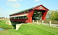
Bigelow Bridge
-
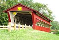
Spain Creek covered bridge
-
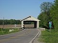
North Lewisburg Road covered bridge
-
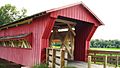
Pottersburg covered bridge


See also
 In Spanish: Condado de Union (Ohio) para niños
