Virginia Military District facts for kids
The Virginia Military District was a large area of land in what is now the state of Ohio. It was about 4.2 million acres (17,000 square kilometers). This land was set aside by the state of Virginia to pay its soldiers who fought in the American Revolutionary War. Instead of cash, veterans received land.
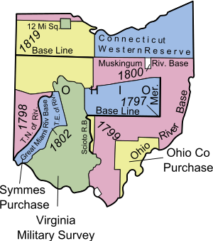
Virginia used to claim a lot of land in the western part of the country, including Ohio. This claim came from its old colonial charter. To help create the Articles of Confederation (an early U.S. government document), Virginia and other states agreed to give up their claims to these western lands in 1784. In return, Virginia was given this special area in Ohio. This land was meant for military land grants. Soldiers were first given land southeast of the Ohio River in what is now Kentucky. The Ohio land was used only after the Kentucky land ran out.
Contents
Where Was the Virginia Military District?
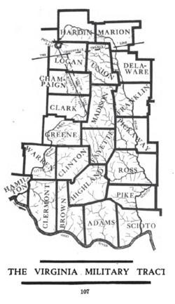
This land was located in southern Ohio. The Ohio River formed its southern border. The Little Miami River was on its western side. The Scioto River bordered it to the east and north.
The District included all of these Ohio counties:
It also covered parts of many other counties, such as Scioto, Pike, Ross, and Franklin.
How Did People Settle the Land?
The Virginia Military District officially opened for settlement in 1794. However, land surveys had already started in the 1780s. The way land was measured here was different from most other parts of the Northwest Territory. In Virginia, they used a method called "metes and bounds." This meant land boundaries were described using natural features like trees, rocks, and rivers. This was different from the "Public Land Survey System" used elsewhere, which divided land into neat squares.
The exact borders of the District caused arguments for many years. Even the U.S. Supreme Court had to make a decision about it. Another problem was the unclear location of a line from the Treaty of Greenville. This line separated Native American lands from lands open to settlers. It ran right through the northern part of the District.
Virginia continued to give out land grants in this area until Ohio became a state in 1803. But because of land speculation (people buying and selling land quickly to make a profit) and fraud, land ownership was very confusing for a long time. The U.S. Congress had to extend the deadline for land claims many times. Eventually, in 1871, any land that was still unclaimed became the property of the state of Ohio.
In 1872, Ohio gave this land to the Ohio Agricultural and Mechanical College. This college is now known as Ohio State University. The college tried to claim lands where ownership was unclear. This sometimes meant families who had lived and farmed the land for many years were forced to leave. This caused a big public outcry. So, in 1880, Congress passed a law to limit the college's rights to these lands.
The first permanent settlement in the District was Massie's Station, founded in 1791. It's now called Manchester, Ohio. It was named after Nathaniel Massie, who was a surveyor and land speculator. He also founded Chillicothe, Ohio in 1796.
Many Virginians who moved to this area did not own slaves. The Northwest Ordinance of 1787, a law for the Northwest Territory, made slavery illegal there. Because of this law, many settlers freed or sold their enslaved people before moving to Ohio.
How Soldiers Claimed Land
Soldiers from Virginia who fought in the Revolutionary War could get a land award. The amount of land depended on their military rank and how long they served.
Here's how they claimed their land:
- First, they needed a certificate proving their military service.
- Next, they got a special paper called a "warrant" from Virginia's land office. This warrant stated how much land they could claim.
- The person with the warrant could then choose their land anywhere within the military reserve district.
- After choosing the location and having the boundaries surveyed, the warrant owner exchanged it for a "patent." A patent was like a deed, giving them full ownership of the land.
The land was not divided into regular square townships, like in other U.S. territories. Instead, it used the "metes and bounds" method from Virginia. This meant land boundaries were based on natural features like trees, boulders, and rivers. This often led to oddly shaped land claims. People tried to get the best land, which sometimes resulted in competing or overlapping claims.
Key Surveyors of the District
- Nathaniel Massie (1791, 1793-1796)
- Richard Clough Anderson Sr. (principal surveyor from 1783 to 1819)
- Allen Latham (son-in-law of Anderson)
- William Marshall Anderson (son of Richard Clough Anderson Sr.)
- Joseph Kerr
 | Aaron Henry |
 | T. R. M. Howard |
 | Jesse Jackson |


