Little Miami River facts for kids
Quick facts for kids Little Miami National Scenic River |
|
|---|---|

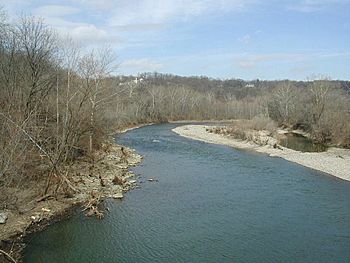
Little Miami River at Milford, Ohio
|
|
| Country | United States |
| Physical characteristics | |
| Main source | 1,151 ft (351 m) 39°49′39″N 83°34′36″W / 39.82750°N 83.57667°W S of Plattsburgh Clark County, Ohio |
| River mouth | 446 ft (136 m) 39°04′41″N 84°25′59″W / 39.07806°N 84.43306°W with the Ohio River at California, Cincinnati Hamilton County, Ohio |
| Length | 111 mi (179 km) |
| Basin features | |
| Basin size | 1,757 sq mi (4,550 km2) |
| Type: | Scenic, Recreational |
| Designated: | August 20, 1973 |
The Little Miami River is a beautiful river in southwestern Ohio, United States. It flows for about 111 miles (179 km) (179 km) through five different counties. This river eventually joins the much larger Ohio River east of Cincinnati.
The Little Miami River is special because it's one of only 156 rivers in America chosen by the U.S. government as a National Wild and Scenic River. This means it's protected for its natural beauty and recreational value. The river also gives its name to the popular Little Miami Scenic Trail, a great place for biking and walking.
Contents
River Flow and Waterways: The Little Miami's Journey
The Little Miami River is a branch, or "tributary," of the Ohio River. It is part of a large area called a watershed. A watershed is like a giant funnel where all the rain and snowmelt collect and drain into a river or lake. The Little Miami's watershed covers about 1,757 square miles (4,550 km2) (4,551 km²) across 11 counties in Ohio.
On average, about 1,280 cubic feet per second (36 m3/s) (36 m³/s) of water flow through the river. After heavy rains, this amount can increase a lot, sometimes reaching 84,100 cubic feet per second (2,380 m3/s) (2,381 m³/s)!
Smaller Rivers Joining the Little Miami
Many smaller streams and rivers flow into the Little Miami. These are called its "tributaries." Some of the main ones include Beaver Creek, Sugar Creek, the East Fork Little Miami, North Fork, Todd's Fork, Duck Creek, Caesar Creek, Massie Creek, and Turtle Creek.
Two of these tributaries have dams that created lakes. The East Fork of the Little Miami was dammed in 1977 to create Harsha Lake, which is now part of East Fork State Park. Similarly, Caesar Creek was dammed in 1973 to form Caesar Creek Lake, located in Caesar Creek State Park.
Where the River Starts and Ends
The very beginning of the Little Miami River, called its "headwaters," is found near Plattsburgh, Ohio in Clark County. From there, the river flows all the way to California, Cincinnati, a neighborhood in Cincinnati, where it joins the Ohio River. As the water travels from its source to its mouth, the river drops about 705-foot (215 m) (215 m) in elevation.
A Look Back: The Little Miami River's Past
The Little Miami River gets its name from the Miami, a Native American tribe who lived in this area a long time ago. They spoke a language called Algonquian.
In the 1960s, people started to realize how special the Little Miami River was. In 1967, a group of people, including newspaper editor Glenn Thompson, formed an organization called Little Miami Incorporated. Their goal was to protect the river. They worked hard to get the Little Miami included in a new law designed to protect important rivers.
Becoming a Protected River
Their efforts paid off! In 1968, a part of the Little Miami River was officially named Ohio's first National Wild and Scenic River. This was a big step in protecting its natural beauty. A year later, in 1969, the river also became Ohio's first State Scenic River, starting from Milford, Ohio up to its headwaters. The rest of the river was added to the State Scenic River list in 1971.
Past Industries and Cleanup Efforts
Long ago, the Little Miami River was used to power factories that made ammunition (bullets and other supplies). Towns like Goes Station and Kings Mills grew up around these factories.
One factory, the Peters Cartridge Company, closed in 1944. Years later, in 1996, the area around this old factory was identified as a place that needed environmental cleanup. This is called a Superfund site. The Ohio Environmental Protection Agency worked to make sure the area was safe again. By 2018, a large part of the site was cleaned up and no longer posed a risk to the river or nearby areas.
Wildlife and Nature: The Little Miami's Ecosystem
The Little Miami River is a lively home for many different kinds of animals. Scientists have found at least 87 types of fish living in its waters. You can also spot many kinds of turtles, frogs, water snakes, and birds.
The river is especially important for mussels, which are small creatures with two shells. There are 36 different species of mussels here! Some of these mussels are considered threatened or even endangered, meaning they are at risk of disappearing forever. Ohio protects five of these mussel species. Unfortunately, some non-native species like zebra mussels and Asiatic clams have moved into the river and are crowding out the native mussels.
To help protect all this amazing wildlife, many nature preserves and state and local parks have been created along the river. These protected areas help keep the river and its surroundings healthy for animals and plants.
Fun on the River: Recreation and Trails
The Little Miami River is a fantastic place for outdoor activities! Since it's a National Scenic River, it's perfect for enjoying nature.
One of the most popular attractions is the Little Miami Scenic Trail. This trail is great for biking, walking, and running. It follows the path of old railroad lines that used to run along the river. This trail is also part of a bigger project called the Ohio to Erie Trail, which aims to connect trails all the way from Lake Erie to the Ohio River.
The Little Miami is also a favorite spot for canoeing and fishing. You can find several places along the river where you can rent a canoe. The fishing for smallmouth bass here is considered some of the best in Ohio! Even though the river flows through farming areas, its water quality is very good.
When you visit, keep an eye out for wildlife! You might see different kinds of turtles, mallards and other ducks, Canada geese, and even tall, graceful blue herons.
Places to See Along the Little Miami River
Here are some interesting places, towns, and points of interest you can find along the Little Miami River, starting from its beginning in Clark County and moving downstream to where it meets the Ohio River:
- Clark County – Where the river begins
- Greene County, Ohio
- Clifton and Clifton Mill
- John Bryan State Park and Clifton Gorge
- Yellow Springs and Glen Helen Nature Preserve
- Beavercreek Township
- Sugarcreek Township
- Bellbrook
- Spring Valley
- Warren County
- Waynesville
- Corwin
- Caesar Creek Gorge – where Caesar Creek meets the river, leading to Caesar Creek Gorge and Lake
- Oregonia
- Mathers Mill – a place for canoes and public access
- Jeremiah Morrow Bridge – a big bridge (Interstate 71) crossing over the river valley
- Fort Ancient – a place for canoes and public access
- Morrow – a place for canoes, where the Todds Fork tributary joins
- South Lebanon
- Kings Mills – home to the historic Peters Cartridge factory
- Fosters – an old settlement and public access point
- Clermont County (east side of river) and Hamilton County (west side of river)
- Chateau LaRoche Museum, also known as Loveland Castle (Hamilton County)
- Loveland – a place for canoes (in both Hamilton and Clermont Counties)
- Lake Isabella, Ohio – (a Hamilton County Park)
- Milford – (Clermont County)
- Hamilton County
- Terrace Park
- Mariemont
- Cincinnati
- Lunken Field – Cincinnati Municipal Airport is located along the river bank
- Ohio River – where the Little Miami River flows into it
 | Shirley Ann Jackson |
 | Garett Morgan |
 | J. Ernest Wilkins Jr. |
 | Elijah McCoy |


