Little Miami Scenic Trail facts for kids
Quick facts for kids Little Miami Scenic Trail |
|
|---|---|

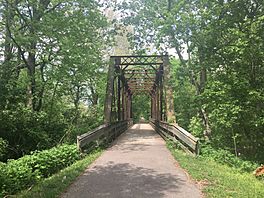
Little Miami Scenic Trail, crossing the Little Miami River near Xenia, Ohio, May 2018
|
|
| Length | 78.1 mi (125.7 km) |
| Location | Southwestern Ohio |
| Designation | North Country National Scenic Trail |
| Trailheads | Springfield to Newtown, Ohio |
| Use | Cycling, walking, rollerblading, horseback riding |
| Elevation change | −486 ft (−148 m) |
| Highest point | Springfield trailhead |
| Lowest point | Little Miami Golf Center trailhead, Newtown |
| Difficulty | Easy (fully accessible) |
| Season | Year-round |
The Little Miami Scenic Trail is a super long paved path in Ohio. It stretches about 78 miles (126 km) through five counties in the southwestern part of the state. This amazing trail is used by lots of people for walking, biking, and even horseback riding! In 2014, over 700,000 people enjoyed this trail.
Most of the trail follows the Little Miami River. It's a special, car-free area known as Little Miami State Park. This park is unique because it's very long and narrow, like a ribbon! It's about 50 miles (80 km) long and usually 66 feet (20 meters) wide. This makes it a safe and fun place to explore nature.
The Little Miami Scenic Trail is also part of a huge network of trails in the Miami Valley area. This network is about 330 miles (530 km) long and connects big cities like Cincinnati, Dayton, and Columbus. The Little Miami trail is also a piece of the Buckeye Trail and the North Country National Scenic Trail, which are even bigger trails that cross many states!
Contents
History of the Trail
This trail was built on the path of an old railroad called the Little Miami Railroad. You can still see parts of the old railway next to the trail in some spots!
Local towns like Xenia and Yellow Springs, along with the Ohio Department of Natural Resources, bought the land from the abandoned railroad between 1973 and 1983. In 1979, this land officially became an Ohio State Park.
Over the years, the trail grew longer. By 1989, it was 13 miles (21 km) long. The first part of the trail was officially opened in 1991. It ran mostly along the eastern side of the Little Miami River. The trail was extended to Xenia later that year and reached Springfield in 1998. In 2006, after a long effort, it was extended south to Newtown.
Around 2008, some parts of the trail started to need repairs because of state budget cuts. This led to some bridges and rest areas being closed temporarily. But a group called the Friends of the Little Miami State Park Group was formed to help keep the trail open and safe. Thanks to their efforts, many bridges were fixed in 2009.
Where the Trail Goes Now

The Little Miami Scenic Trail officially starts in Springfield. For the first 9 miles (14 km) to Xenia, it's managed by the Clark County Park District. From Springfield, the trail goes south, passing through Yellow Springs. Near John Bryan State Park, other trails like the North Country Trail join in.
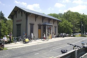
For the next 15 miles (24 km) to Spring Valley, the trail is managed by Greene County. At Xenia Station, the Little Miami trail connects with the Creekside Trail and the Prairie Grass Trail. A small part of the Little Miami trail here is also known as U.S. Bike Route 50.
The Little Miami State Park section of the trail begins in Spring Valley. It quickly meets the Little Miami River and follows it into Warren County. The trail goes through towns like Corwin and Oregonia. At Fort Ancient, the trail passes under the huge Jeremiah Morrow Bridge. It then goes through the downtown areas of Morrow and South Lebanon.
The trail continues south, passing by the historic Peters Cartridge Company building. It goes under U.S. Route 22/State Route 3 at Fosters. Then it enters Clermont County and the town of Loveland, where it's known as the Loveland Bike Trail.
At Miamiville, the trail crosses to the other side of the Little Miami River, into Hamilton County. It passes by Camp Dennison and used to end in Milford. A 2006 extension took the trail further south to Avoca Park in Terrace Park. From here, a part of the Buckeye Trail branches off towards Cincinnati.
Finally, a short extension leads the Little Miami trail back across the river to the Little Miami Golf Center in Newtown. The North Country Trail continues southeast from here.
The Little Miami Scenic Trail goes even further south for another 3.2 miles (5.1 km) from the Little Miami Golf Center to Clear Creek Park.
Future Plans for the Trail
There are plans to build a special bike bridge over the Little Miami River. This bridge would connect the Little Miami Scenic Trail to another trail called the Armleder Trail Connector. This would make the Ohio River Trail a continuous path all the way to downtown Cincinnati.
Organizations like the Adventure Cycling Association also want to make the Little Miami Scenic Trail part of U.S. Bicycle Route 25, which is a national bike route system.
Trail's Impact on the Area
Studies done in 2008 and 2011 showed that homes located closer to the Little Miami Scenic Trail actually increased in value. This means the trail is a great benefit to the communities it passes through!
 | Charles R. Drew |
 | Benjamin Banneker |
 | Jane C. Wright |
 | Roger Arliner Young |


