Ohio to Erie Trail facts for kids
Quick facts for kids Ohio to Erie Trail |
|
|---|---|

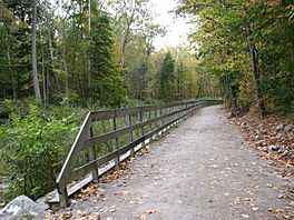
Ohio and Erie Canal Towpath Trail, located in the Cuyahoga Valley National Park
|
|
| Length | 318 mi (512 km) |
| Location | Ohio, United States |
| Designation | |
| Trailheads | Cincinnati to Cleveland (various) |
| Use | Multi-use |
| Season | Year-round |
The Ohio to Erie Trail is a super long path across the state of Ohio. It's made for people who want to travel without a motor, like bikers and hikers. This amazing trail stretches all the way from the Ohio River in Cincinnati to Lake Erie in Cleveland.
Most of the trail follows old railroad lines or other special paths just for bikes and walkers. Some parts are on regular roads, but the plan is to make them special paths too. The trail is mostly for bikes and hikers. However, some sections also allow horses and even horse-drawn buggies.
Contents
The Trail's Beginning
The idea for the Ohio to Erie Trail started in 1991. A person named Edward Franklin Honton first imagined this long path. He wanted to create a way for people to travel across Ohio without cars.
Edward Honton's Vision
Edward Honton didn't just dream about the trail. He also started a special group called a non-profit organization. This group worked hard to make the trail a real thing. Even after he passed away in 2005, his group, The Ohio to Erie Trail Fund, kept working on his dream.
A Special Bridge Tribute
In 2011, a historic bridge was named in honor of Ed Honton. This bridge is called the Bridgeview Bridge. It was built in 1902 and was carefully fixed up. It's now part of the Alum Creek Trail, which is a section of the bigger Ohio to Erie Trail.
Exploring the Trail Sections
The Ohio to Erie Trail is divided into four main parts. Each part helps you explore a different area of Ohio.
- Northern leg: This section goes from Cleveland to Massillon.
- Heart of Ohio leg: This part stretches from Massillon to Mount Vernon.
- Central Ohio leg: You can travel from Mount Vernon to London on this section.
- Southern leg: This final part connects London to Cincinnati.
What You'll See on the Trail
As you travel along the trail, you'll pass through many interesting places. These include regional parks and nature preserves. You'll also see lots of rural woodlands and beautiful natural areas.
How Long is the Trail?
The Ohio to Erie Trail is planned to be about 326 miles long when it's all finished. As of November 2016, a big part of it is already done. About 267 miles are open and ready for people to use every day. The remaining 59 miles are either being built or are in the planning stages.
 | Selma Burke |
 | Pauline Powell Burns |
 | Frederick J. Brown |
 | Robert Blackburn |

