Pike County, Ohio facts for kids
Quick facts for kids
Pike County
|
|||
|---|---|---|---|

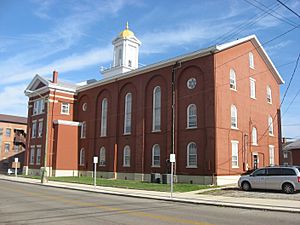
Pike County Courthouse in Waverly.
|
|||
|
|||

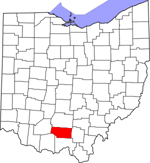
Location within the U.S. state of Ohio
|
|||
 Ohio's location within the U.S. |
|||
| Country | |||
| State | |||
| Founded | February 1, 1815 | ||
| Named for | Zebulon Pike | ||
| Seat | Waverly | ||
| Largest city | Waverly | ||
| Area | |||
| • Total | 444 sq mi (1,150 km2) | ||
| • Land | 440 sq mi (1,100 km2) | ||
| • Water | 3.7 sq mi (10 km2) 0.8%% | ||
| Population
(2020)
|
|||
| • Total | 27,088 |
||
| • Density | 61/sq mi (24/km2) | ||
| Time zone | UTC−5 (Eastern) | ||
| • Summer (DST) | UTC−4 (EDT) | ||
| Congressional district | 2nd | ||
Pike County is a special area in the southern part of Ohio, a state in the United States. This region is known as Appalachia, which has beautiful mountains and hills.
As of the 2020 count, about 27,088 people live here. The main town, or county seat, is Waverly. Pike County got its name from a famous explorer named Zebulon Pike.
Contents
History of Pike County
Pike County was officially created on February 1, 1815. It was formed from parts of three other counties: Scioto, Ross, and Adams. The county was named to honor Zebulon Pike, who was an explorer and a soldier. He had recently passed away during the War of 1812.
Geography of Pike County
Pike County covers a total area of about 444 square miles. Most of this area, about 440 square miles, is land. The rest, about 3.7 square miles, is water, which is less than 1% of the total area.
Neighboring Counties in Ohio
Pike County shares its borders with several other counties:
- Ross County is to the north.
- Jackson County is to the east.
- Scioto County is to the south.
- Adams County is to the southwest.
- Highland County is to the west.
Population and People of Pike County
The number of people living in Pike County has changed over many years. Here's a look at how the population has grown and changed:
| Historical population | |||
|---|---|---|---|
| Census | Pop. | %± | |
| 1820 | 4,253 | — | |
| 1830 | 6,024 | 41.6% | |
| 1840 | 7,626 | 26.6% | |
| 1850 | 10,953 | 43.6% | |
| 1860 | 13,643 | 24.6% | |
| 1870 | 15,447 | 13.2% | |
| 1880 | 17,927 | 16.1% | |
| 1890 | 17,482 | −2.5% | |
| 1900 | 18,172 | 3.9% | |
| 1910 | 15,723 | −13.5% | |
| 1920 | 14,151 | −10.0% | |
| 1930 | 13,876 | −1.9% | |
| 1940 | 16,113 | 16.1% | |
| 1950 | 14,607 | −9.3% | |
| 1960 | 19,380 | 32.7% | |
| 1970 | 19,114 | −1.4% | |
| 1980 | 22,802 | 19.3% | |
| 1990 | 24,249 | 6.3% | |
| 2000 | 27,695 | 14.2% | |
| 2010 | 28,709 | 3.7% | |
| 2020 | 27,088 | −5.6% | |
| U.S. Decennial Census 1790-1960 1900-1990 1990-2000 2020 |
|||
Pike County in 2010
In 2010, there were 28,709 people living in Pike County. These people lived in 11,012 households, with 7,743 of them being families. On average, there were about 65 people per square mile.
Most people in the county were white (96.6%). A smaller number were Black or African American (0.9%), American Indian (0.5%), or Asian (0.2%). About 1.6% of people were from two or more races. People of Hispanic or Latino background made up 0.7% of the population.
Many families had children under 18 living with them (34.6%). About half of the households (51.2%) were married couples. The average age of people in Pike County was about 39 years old.
The average yearly income for a household was $35,912. For families, it was $43,010. About 23.6% of all people in the county lived below the poverty line. This included 32.7% of children under 18.
Communities in Pike County
Pike County has several towns and smaller communities.
Main City
- Waverly is the largest city and the county seat.
Villages in Pike County
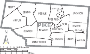
Townships in Pike County
- Beaver
- Benton
- Camp Creek
- Jackson
- Marion
- Mifflin
- Newton
- Pebble
- Pee Pee
- Perry
- Scioto
- Seal
- Sunfish
- Union
Census-Designated Places
These are areas that are like towns but are not officially incorporated as cities or villages.
Unincorporated Communities
These are smaller communities that are not part of any city or village.
See also
 In Spanish: Condado de Pike (Ohio) para niños
 | Victor J. Glover |
 | Yvonne Cagle |
 | Jeanette Epps |
 | Bernard A. Harris Jr. |


