
Adams County, Ohio facts for kids
Quick facts for kids
Adams County
|
|||
|---|---|---|---|

|
|||
|
|||

Location within the U.S. state of Ohio
|
|||
 Ohio's location within the U.S. |
|||
| Country | |||
| State | |||
| Founded | July 10, 1797 | ||
| Named for | John Adams | ||
| Seat | West Union | ||
| Largest village | West Union | ||
| Area | |||
| • Total | 586 sq mi (1,520 km2) | ||
| • Land | 584 sq mi (1,510 km2) | ||
| • Water | 2.4 sq mi (6 km2) 0.4%% | ||
| Population
(2020)
|
|||
| • Total | 27,477 |
||
| • Density | 47/sq mi (18/km2) | ||
| Time zone | UTC−5 (Eastern) | ||
| • Summer (DST) | UTC−4 (EDT) | ||
| Congressional district | 2nd | ||


Adams County is a county located in the state of Ohio in the United States. In 2020, about 27,477 people lived there. The main town and largest village is West Union. Adams County is named after John Adams, who was the second President of the United States.
Contents
Where is Adams County?
Adams County covers an area of about 586 square miles. Most of this is land, with a small part being water. It's known for its many parks and natural areas. One of the most famous spots is the Serpent Mound at the Serpent Mound State Memorial. This is a huge, ancient earthwork shaped like a snake.
The area around Serpent Mound also has a large, old crater from a meteorite impact. Other cool places to explore include The Edge of Appalachia Preserve, Shawnee State Park, Adams Lake State Park, and Robert H. Whipple State Nature Preserve.
What counties are next to Adams County?
Adams County shares its borders with several other counties:
- Highland County to the north
- Pike County to the northeast
- Scioto County to the east
- Lewis County, Kentucky to the south
- Mason County, Kentucky to the southwest
- Brown County to the west
What are the protected natural areas?
Adams County has several state-protected natural areas. These places help keep the local plants and animals safe. Some of them are:
- Adams Lake State Park
- Chaparral Prairie State Nature Preserve
- Davis Memorial State Nature Preserve
- Johnson Ridge State Nature Preserve
- Lynx Prairie
- Shoemaker State Nature Preserve
- Whipple State Nature Preserve
How many people live in Adams County?
| Historical population | |||
|---|---|---|---|
| Census | Pop. | %± | |
| 1800 | 3,432 | — | |
| 1810 | 9,434 | 174.9% | |
| 1820 | 10,406 | 10.3% | |
| 1830 | 12,281 | 18.0% | |
| 1840 | 13,183 | 7.3% | |
| 1850 | 18,883 | 43.2% | |
| 1860 | 20,309 | 7.6% | |
| 1870 | 20,750 | 2.2% | |
| 1880 | 24,005 | 15.7% | |
| 1890 | 26,093 | 8.7% | |
| 1900 | 26,328 | 0.9% | |
| 1910 | 24,755 | −6.0% | |
| 1920 | 22,403 | −9.5% | |
| 1930 | 20,381 | −9.0% | |
| 1940 | 21,705 | 6.5% | |
| 1950 | 20,499 | −5.6% | |
| 1960 | 19,982 | −2.5% | |
| 1970 | 18,957 | −5.1% | |
| 1980 | 24,328 | 28.3% | |
| 1990 | 25,371 | 4.3% | |
| 2000 | 27,330 | 7.7% | |
| 2010 | 28,550 | 4.5% | |
| 2020 | 27,477 | −3.8% | |
| U.S. Decennial Census 1790–1960 1900–1990 1990–2000 2020 |
|||
In 2010, there were 28,550 people living in Adams County. Most people were white (97.7%). About 0.9% of the population was of Hispanic or Latino background. Many families had children under 18 living with them. The average age of people in the county was about 39.6 years old.
By 2020, the population had slightly decreased to 27,477 people.
What is the economy like?
About 10,100 people work in Adams County. The biggest job areas are manufacturing (making things), retail trade (stores), and health care. Some of the jobs that pay the most are in utilities (like electricity or water) and finance.
In 2019, a report showed that Adams County had a higher poverty rate compared to other parts of Ohio. The average household income was also lower than the state average. These economic conditions led to a small decrease in the county's population over five years.
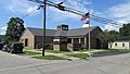
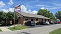
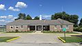
What about the library?
The Adams County Public Library serves the people of Adams County. It has its main office in Peebles. There are also other branches in Manchester, West Union, and Seaman.
In 2005, the library system loaned out over 264,000 items. They had more than 14,000 people with library cards. The library owned over 101,000 books and other items.
-
Peebles Library
-
Manchester Library
-
West Union Library
-
Seaman Library


Is there a hospital?
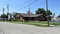
Yes, Adams County has a hospital called the Adams County Regional Medical Center. It is located near Seaman. The hospital used to be in West Union and was called Adams County Hospital. It moved to its new location and was renamed. It is easy to get to from the Appalachian Highway.
What are the communities like?

Adams County has several villages and many smaller communities.
Villages
- Manchester
- Peebles
- Rome
- Seaman
- West Union (This is the county seat, where the county government is located)
- Winchester
Townships
- Bratton
- Brush Creek
- Franklin
- Green
- Jefferson
- Liberty
- Manchester
- Meigs
- Monroe
- Oliver
- Scott
- Sprigg
- Tiffin
- Wayne
- Winchester
Census-designated places
These are areas that are like towns but are not officially incorporated as villages.
Other small communities
- Bacon Flat
- Beasley Fork
- Beaver Pond
- Blue Creek
- Bradysville
- Catbird
- Cedar Mills
- Clayton
- Dunkinsville
- Eckmansville
- Emerald
- Fairview
- Fawcett
- Grooms
- Harshaville
- Jacksonville
- Jaybird
- Jessup
- Jones Corner
- Lawshe
- Locust Grove
- Louden
- Louisville
- Lynx
- Marble Furnace
- May Hill
- Mineral Springs
- Panhandle
- Pine Gap
- Rockville
- Sandy Springs
- Scrub Ridge
- Smoky Corners
- Squirreltown
- Selig
- Steam Furnace
- Sunshine
- Tranquility
- Tulip
- Unity
- Wamsley
- Wheat Ridge
- Whippoorwill
- Wrightsville
- Youngsville
What are some interesting places to visit?
- Great Serpent Mound: A famous ancient earthwork shaped like a snake.
- Counterfeit House: A unique house in the Manchester area. It was built long ago for the purpose of making fake money.
- Brushcreek Motorsports Complex: A place for racing and motorsports events.
-
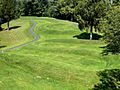
Serpent Mound
-
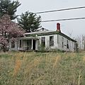
Counterfeit House
-
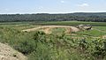
Brushcreek Motorsports Complex


Who are some famous people from Adams County?
Adams County has been home to several notable individuals, including:
- Afroman: A well-known rapper.
- Cowboy Copas: A famous country music singer.
- Joseph Darlinton: A brigadier general during the War of 1812. He also represented Adams County in the Ohio Senate.
- John Glasgow Kerr: A respected doctor and missionary. He founded the first hospital for people with mental illness in China.
- Thomas Kirker: The second Governor of Ohio.
- John P. Leedom: A United States congressman from Ohio.
- Philip Lewis Sr.: An early pioneer and important politician in Adams County.
- Daniel McCann: Known for selling the famous eagle Old Abe to a Wisconsin army regiment during the Civil War.
- William H. Reddick: Received the Medal of Honor for his brave service in the 33rd Ohio Infantry.
- Jack Roush: The founder, CEO, and co-owner of Roush Fenway Racing, a major auto racing team.
See also
 In Spanish: Condado de Adams (Ohio) para niños
