West Union, Ohio facts for kids
Quick facts for kids
West Union, Ohio
|
|
|---|---|
|
Village
|
|

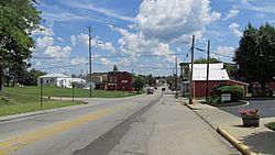
Looking east on Main Street
|
|

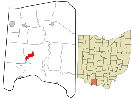
Location in Adams County and the state of Ohio.
|
|
| Country | United States |
| State | Ohio |
| County | Adams |
| Area | |
| • Total | 2.83 sq mi (7.33 km2) |
| • Land | 2.83 sq mi (7.33 km2) |
| • Water | 0.00 sq mi (0.00 km2) |
| Elevation | 873 ft (266 m) |
| Population
(2020)
|
|
| • Total | 3,004 |
| • Density | 1,061.11/sq mi (409.71/km2) |
| Time zone | UTC-5 (Eastern (EST)) |
| • Summer (DST) | UTC-4 (EDT) |
| ZIP code |
45693
|
| Area code(s) | 937, 326 |
| FIPS code | 39-84294 |
| GNIS feature ID | 2400146 |
| Website | www.westunionoh.net |
West Union is a small village located in Adams County, Ohio, United States. It is about 55 miles (88 kilometers) southeast of Cincinnati. In 2020, the population of West Union was 3,004 people. This village is important because it is the "county seat" of Adams County. This means it's where the main government offices for the county are located.
Students in West Union attend West Union High School. The village is part of the Adams County/Ohio Valley School District. For reading and learning, residents can visit the West Union Public Library. This library is a branch of the Adams County Public Library.
Contents
Village History: How West Union Began
West Union was first planned out in the year 1803. It started as a new settlement. A post office opened in West Union in 1805, helping people send and receive mail. The village officially became a town, or "incorporated," in 1859.
Geography: Where West Union is Located
West Union covers a total area of about 2.83 square miles (7.33 square kilometers). All of this area is land. There are no large bodies of water within the village limits.
Major Roads in West Union
Several important roads meet and run through the downtown area of West Union. These include State Route 41, State Route 125, and State Route 247.
West Union vs. Union, Ohio
It might seem a bit confusing, but West Union is actually located east of another city in Ohio called Union, Ohio. These two places are not close to each other. They are about 120 miles (193 kilometers) apart.
Population Changes in West Union
| Historical population | |||
|---|---|---|---|
| Census | Pop. | %± | |
| 1810 | 229 | — | |
| 1820 | 406 | 77.3% | |
| 1830 | 429 | 5.7% | |
| 1840 | 462 | 7.7% | |
| 1850 | 444 | −3.9% | |
| 1860 | 450 | 1.4% | |
| 1870 | 486 | 8.0% | |
| 1880 | 626 | 28.8% | |
| 1890 | 825 | 31.8% | |
| 1900 | 1,033 | 25.2% | |
| 1910 | 1,080 | 4.5% | |
| 1920 | 992 | −8.1% | |
| 1930 | 1,094 | 10.3% | |
| 1940 | 1,334 | 21.9% | |
| 1950 | 1,508 | 13.0% | |
| 1960 | 1,762 | 16.8% | |
| 1970 | 1,951 | 10.7% | |
| 1980 | 2,791 | 43.1% | |
| 1990 | 3,096 | 10.9% | |
| 2000 | 2,903 | −6.2% | |
| 2010 | 3,241 | 11.6% | |
| 2020 | 3,004 | −7.3% | |
| U.S. Decennial Census | |||
West Union's Population in 2010
According to the census from 2010, West Union had 3,241 people living there. There were 1,322 households in the village. The population density was about 1,145 people per square mile (442 people per square kilometer).
Most of the people living in West Union were White (97.4%). A smaller number of residents were African American, Native American, or Asian. Some people identified as being from two or more races. About 0.8% of the population was Hispanic or Latino.
In terms of age, the average age in the village was 40.1 years old. About 23.4% of the residents were under 18 years old. About 20.2% of the people were 65 years old or older. The village had more females (54.5%) than males (45.5%).
Notable People from West Union
- Edmund Wittenmyer was a U.S. Army major general. Before his military career, he taught school in West Union. He taught there from 1876 to 1883.
See also
 In Spanish: West Union (Ohio) para niños
 | William Lucy |
 | Charles Hayes |
 | Cleveland Robinson |

