Brown County, Ohio facts for kids
Quick facts for kids
Brown County
|
|||
|---|---|---|---|
|
|||
|
|||
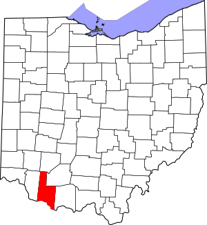
Location within the U.S. state of Ohio
|
|||
 Ohio's location within the U.S. |
|||
| Country | |||
| State | |||
| Founded | March 1, 1818 | ||
| Named for | General Jacob Brown | ||
| Seat | Georgetown | ||
| Largest village | Georgetown | ||
| Area | |||
| • Total | 493 sq mi (1,280 km2) | ||
| • Land | 490 sq mi (1,300 km2) | ||
| • Water | 3.4 sq mi (9 km2) 0.7%% | ||
| Population
(2020)
|
|||
| • Total | 43,676 |
||
| • Density | 89/sq mi (34/km2) | ||
| Time zone | UTC−5 (Eastern) | ||
| • Summer (DST) | UTC−4 (EDT) | ||
| Congressional district | 2nd | ||
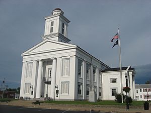
Brown County is a special area, or county, in the state of Ohio, United States. In 2020, about 43,676 people lived there. The main town, or "county seat," is Georgetown.
Brown County was officially started in 1818. It was named after Major General Jacob Brown. He was a brave soldier who fought in the War of 1812. Brown County is also part of the larger Cincinnati area, which includes parts of Ohio, Kentucky, and Indiana.
Contents
History of Brown County
After the American Revolutionary War, the United States government created a huge area called the Northwest Territory. This territory included the land where Brown County is today. Over time, smaller counties were formed from this large territory.
In 1797, Adams County was created. Then, in 1800, Clermont County was also formed. Many people started to settle in the area north of the Ohio River.
One of the early settlers was Jesse Root Grant. He was the father of Ulysses S. Grant, who later became a US President. Jesse Grant built a home and a tannery (a place to make leather) in what would become Georgetown. Young Ulysses spent his childhood there.
On March 1, 1818, parts of Adams and Clermont counties were combined to create Brown County. Georgetown became its main town. In 1874, a small part of Brown County was moved to Highland County. The county's borders have stayed the same since then.
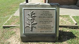
Brown County is also known as the birthplace of a special kind of tobacco called White Burley. In 1864, two farmers, George Webb and Joseph Fore, grew it near Higginsport. They noticed it had a different, lighter leaf. By 1866, they had grown a lot of it. This new type of tobacco became very popular and was later called burley tobacco.
Geography of Brown County
Brown County is located on the southern edge of Ohio. Its southern border is next to Kentucky, with the Ohio River flowing between them. Several creeks flow through the county and into the Ohio River, like White Oak Creek, Straight Creek, and Eagle Creek. The east fork of the Little Miami River also flows through the northern part of the county.
Brown County has gently rolling hills and farmland. The highest point in the county is on Ash Ridge, which is about 1,089 feet (332 meters) above sea level. The county covers about 493 square miles (1,277 square kilometers). Most of this area, about 490 square miles (1,269 square kilometers), is land. The rest is water.
Main Roads
Many important roads run through Brown County, connecting its towns and neighboring areas. These include:
 US 50
US 50 US 52
US 52 US 62
US 62 US 68
US 68 SR 32
SR 32 SR 125
 SR 131
 SR 134
 SR 221
 SR 286
 SR 353
 SR 505
 SR 756
 SR 763
 SR 774
Neighboring Counties
Brown County shares its borders with several other counties:
- Clinton County - to the north
- Highland County - to the northeast
- Adams County - to the east
- Mason County, Kentucky - to the southeast (across the Ohio River)
- Bracken County, Kentucky - to the southwest (across the Ohio River)
- Clermont County - to the west
Lakes
Brown County is home to a few lakes, which are great for recreation:
- Grant Lake
- Lake Lorelei
- Lake Waynoka
Protected Natural Areas
There are also special areas in Brown County set aside to protect wildlife and nature:
- Della Gates and Charles Bott Wildlife Area
- Grant Lake Wildlife Area
- Indian Creek Wildlife Area
- Eagle Creek Wildlife Area
Population Information
| Historical population | |||
|---|---|---|---|
| Census | Pop. | %± | |
| 1820 | 13,356 | — | |
| 1830 | 17,867 | 33.8% | |
| 1840 | 22,715 | 27.1% | |
| 1850 | 27,332 | 20.3% | |
| 1860 | 29,958 | 9.6% | |
| 1870 | 30,802 | 2.8% | |
| 1880 | 32,911 | 6.8% | |
| 1890 | 29,899 | −9.2% | |
| 1900 | 28,237 | −5.6% | |
| 1910 | 24,832 | −12.1% | |
| 1920 | 22,621 | −8.9% | |
| 1930 | 20,148 | −10.9% | |
| 1940 | 21,638 | 7.4% | |
| 1950 | 22,221 | 2.7% | |
| 1960 | 25,178 | 13.3% | |
| 1970 | 26,635 | 5.8% | |
| 1980 | 31,920 | 19.8% | |
| 1990 | 34,966 | 9.5% | |
| 2000 | 42,285 | 20.9% | |
| 2010 | 44,846 | 6.1% | |
| 2020 | 43,676 | −2.6% | |
| US Decennial Census 1790-1960 1900-1990 1990-2000 2020 |
|||
In 2010, there were 44,846 people living in Brown County. There were about 17,014 households, which are groups of people living together. The average household had about 2.6 people. The average age of people in the county was around 39.9 years old.
Local Media
Radio Stations
- WRAC C103 Country 103.1 FM (West Union)
- WAOL 99.5 (Ripley)
Newspapers
- The News Democrat (Georgetown)
- The Brown County Press (Mount Orab)
- The County Free Press (Georgetown, Monthly)
- The Ripley Bee (Ripley, Weekly)
Towns and Communities
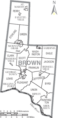
Brown County has many different towns and smaller communities.
Villages
These are smaller towns with their own local governments:
- Aberdeen
- Fayetteville
- Georgetown (This is the county seat, the main town)
- Hamersville
- Higginsport
- Mount Orab
- Ripley
- Russellville
- Sardinia
Census-Designated Places
These are areas that are like towns but don't have their own local governments:
Unincorporated Communities
These are smaller places that are not officially part of a village or city:
- Arnheim
- Ash Ridge
- Bardwell
- Boudes Ferry
- Brownstown
- Centerville
- Chasetown
- Crosstown
- Decatur
- Eastwood
- Ellsberry
- Feesburg
- Fincastle
- Fivemile
- Greenbush
- Hiett
- Levanna
- Locust Ridge
- Macon
- Maple
- Neals Corner
- Neel
- New Harmony
- New Hope
- Redoak
- Upper Fivemile
- Vera Cruz
- Wahlsburg
- White Oak
- White Oak Valley
Townships
Townships are smaller divisions of the county, often including rural areas and smaller communities:
- Byrd
- Clark
- Eagle
- Franklin
- Green
- Huntington
- Jackson
- Jefferson
- Lewis
- Perry
- Pike
- Pleasant
- Scott
- Sterling
- Union
- Washington
See also
 In Spanish: Condado de Brown (Ohio) para niños
 | Aurelia Browder |
 | Nannie Helen Burroughs |
 | Michelle Alexander |


