
Ripley, Ohio facts for kids
Quick facts for kids
Ripley, Ohio
|
|
|---|---|
|
Village
|
|

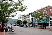
Looking north on Second Street (U.S. Route 52) in Ripley
|
|
| Motto(s):
"Freedoms Landing - Where thousands found freedom on the Underground Railroad"
|
|

Location of Ripley, Ohio
|
|

Location of Ripley in Brown County
|
|
| Country | United States |
| State | Ohio |
| County | Brown |
| Township | Union |
| Named for | Eleazer Wheelock Ripley |
| Area | |
| • Total | 2.29 sq mi (5.94 km2) |
| • Land | 1.99 sq mi (5.15 km2) |
| • Water | 0.31 sq mi (0.79 km2) |
| Elevation | 535 ft (163 m) |
| Population
(2020)
|
|
| • Total | 1,591 |
| • Density | 799.90/sq mi (308.88/km2) |
| Time zone | UTC-5 (Eastern (EST)) |
| • Summer (DST) | UTC-4 (EDT) |
| ZIP code |
45167
|
| Area code(s) | 937, 326 |
| FIPS code | 39-67272 |
| GNIS feature ID | 2399079 |
Ripley is a small village located in Brown County, Ohio, United States. It sits right along the Ohio River, about 50 miles southeast of the city of Cincinnati. In 2020, about 1,591 people lived in Ripley.
Contents
History of Ripley
Founding the Village
Ripley was founded by Colonel James Poage. He was a soldier in the American Revolution, which was the war that created the United States. In 1804, he came to Ohio from Virginia. He had been given 1,000 acres of land for his service in the war. Many other soldiers also received land in this area, which was called the Virginia Military District.
When these soldiers settled in Ohio, they often freed their slaves. Ohio was a free state, meaning slavery was not allowed there. Colonel Poage and his family planned the town in 1812 and named it Staunton. In 1816, the town's name was changed to Ripley. This was to honor General Eleazar Wheelock Ripley, another American officer from the War of 1812.
Ripley and the Underground Railroad
Because Ripley is right on the Ohio River, it became a very important place for people escaping slavery. Many enslaved people from Kentucky, which was a slave state, would cross the river to reach freedom in Ohio.
Both Black and white residents in Ripley worked together to help these people. They created a secret network known as the Underground Railroad. Ripley was one of the first safe stops on this journey north to freedom.
Many important people who fought against slavery, called abolitionists, lived in Ripley in the 1800s. They often lived on Front Street, close to the river.
One famous abolitionist was John Rankin. He moved to Ripley in 1822. He built a house on Liberty Hill, which overlooked the town, the river, and Kentucky. From his house, he would use a lantern on a flagpole to signal to enslaved people crossing the river. He would then offer them a safe place to stay. Today, his house is called the John Rankin House. It is a special landmark because of its history. John Rankin was also a minister at the Ripley Presbyterian Church for 24 years.
Geography of Ripley
Ripley is located in a scenic area. The village is surrounded by steep, rolling hills to the northeast. Red Oak Creek is to the southeast, and the wide Ohio River is to the southwest.
The village covers a total area of about 2.30 square miles (5.94 square kilometers). Most of this area, about 1.99 square miles (5.15 square kilometers), is land. The rest, about 0.31 square miles (0.79 square kilometers), is water, mainly from the Ohio River.
Population of Ripley
| Historical population | |||
|---|---|---|---|
| Census | Pop. | %± | |
| 1820 | 421 | — | |
| 1830 | 572 | 35.9% | |
| 1840 | 816 | 42.7% | |
| 1850 | 1,780 | 118.1% | |
| 1860 | 2,715 | 52.5% | |
| 1870 | 2,323 | −14.4% | |
| 1880 | 2,546 | 9.6% | |
| 1890 | 2,483 | −2.5% | |
| 1900 | 2,248 | −9.5% | |
| 1910 | 1,840 | −18.1% | |
| 1920 | 1,529 | −16.9% | |
| 1930 | 1,556 | 1.8% | |
| 1940 | 1,623 | 4.3% | |
| 1950 | 1,792 | 10.4% | |
| 1960 | 2,174 | 21.3% | |
| 1970 | 2,745 | 26.3% | |
| 1980 | 2,174 | −20.8% | |
| 1990 | 1,816 | −16.5% | |
| 2000 | 1,745 | −3.9% | |
| 2010 | 1,750 | 0.3% | |
| 2020 | 1,591 | −9.1% | |
| U.S. Decennial Census | |||
Population in 2010
In 2010, there were 1,750 people living in Ripley. Most of the people living in the village were White (92.6%). About 4.9% were African American. A small number of people were Native American or Asian. About 0.5% of the population was Hispanic or Latino.
The average age of people in Ripley in 2010 was about 42 years old. About 24% of the residents were under 18 years old.
Notable People from Ripley
Many interesting people have connections to Ripley:
- William Q. Atwood: A former slave who became a notable figure.
- Alexander Campbell: A politician.
- Steven M. Newman: Known as "The Worldwalker," he was the first person to walk solo around the world.
- John Parker: An abolitionist, inventor, and businessman.
- John Rankin: A famous abolitionist and minister.
- Russell Smith: A talented jazz trumpeter.
- Steve Stivers: A U.S. Representative for Ohio.
- Colonel Charles Young: The first Black man to reach the rank of colonel in the United States Army.
Gallery
-
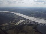
Aerial view of Ripley from the north.
-
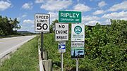
Ripley corporation limit sign.
-
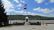
Liberty Monument on the Ohio River that was dedicated in 1912.
-
Main Street ends at the Ohio River in Ripley, Ohio.
-
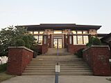
Union Township Public Library, Ripley, Ohio, 2015
-
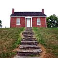
John Rankin House, Ripley, Ohio, 2005


See also
 In Spanish: Ripley (Ohio) para niños
