
Manchester, Ohio facts for kids
Quick facts for kids
Manchester, Ohio
|
|
|---|---|
|
Village
|
|

Second Street (US 52)
|
|

Location in Manchester Township, Adams County and the state of Ohio.
|
|
| Country | United States |
| State | Ohio |
| County | Adams |
| Area | |
| • Total | 1.29 sq mi (3.33 km2) |
| • Land | 1.27 sq mi (3.28 km2) |
| • Water | 0.02 sq mi (0.05 km2) |
| Elevation | 512 ft (156 m) |
| Population
(2020)
|
|
| • Total | 1,839 |
| • Density | 1,451.46/sq mi (560.23/km2) |
| Time zone | UTC-5 (Eastern (EST)) |
| • Summer (DST) | UTC-4 (EDT) |
| ZIP code |
45144
|
| Area codes | 937, 326 |
| FIPS code | 39-47012 |
| GNIS feature ID | 2399237 |
Manchester is a small town, called a village, in Adams County, Ohio, United States. It is located right next to the Ohio River. In 2020, about 1,839 people lived in Manchester.
Contents
History of Manchester
Manchester was first started in 1790. It was called Massie's Station. It was named after Nathaniel Massie, an explorer. This was the first lasting settlement in the area. It was built by the Ohio River, near three islands.
In 1791, its name changed to Manchester, Ohio. This new name came from Manchester, England. That was where Massie's family came from. Manchester was the fourth permanent settlement in the Northwest Territory. By 1791, people had built a strong fence, called a stockade, around the whole community for protection.
A college named Alfred Holbrook College moved to Manchester in 1933. It closed down in 1941.
Geography and Location
Manchester is a village that covers about 1.29 square miles (3.33 square kilometers). Most of this area is land. Only a tiny part is water.
The village is located where two main roads meet. These are U.S. Route 52 and Ohio State Route 136. Manchester is about halfway between two larger cities: Cincinnati and Huntington, West Virginia.
People of Manchester: Demographics
| Historical population | |||
|---|---|---|---|
| Census | Pop. | %± | |
| 1850 | 434 | — | |
| 1870 | 942 | — | |
| 1880 | 1,455 | 54.5% | |
| 1890 | 1,965 | 35.1% | |
| 1900 | 2,003 | 1.9% | |
| 1910 | 1,966 | −1.8% | |
| 1920 | 1,824 | −7.2% | |
| 1930 | 2,009 | 10.1% | |
| 1940 | 2,163 | 7.7% | |
| 1950 | 2,281 | 5.5% | |
| 1960 | 2,172 | −4.8% | |
| 1970 | 2,195 | 1.1% | |
| 1980 | 2,313 | 5.4% | |
| 1990 | 2,223 | −3.9% | |
| 2000 | 2,043 | −8.1% | |
| 2010 | 2,023 | −1.0% | |
| 2020 | 1,839 | −9.1% | |
| U.S. Decennial Census | |||
Population in 2010
In 2010, about 2,023 people lived in Manchester. There were 818 households, which are groups of people living together. About 527 of these were families. The village had about 1,580 people per square mile.
Most people in Manchester were White (96.2%). A small number were African American (0.2%), Native American (0.4%), or Asian (0.1%). Some people were from other races (0.7%) or mixed races (2.4%). About 1.7% of the population was Hispanic or Latino.
About 34.2% of households had children under 18. Many households (39.4%) were married couples. Some households (19.2%) had a female head without a husband. A small number (5.9%) had a male head without a wife. About 35.6% of households were not families.
The average age of people in Manchester was 38.1 years old. About 26.7% of residents were under 18. About 15.6% were 65 or older. The population was almost evenly split between males (48.2%) and females (51.8%).
Education in Manchester
Students in Manchester go to schools in the Manchester Local School District. The village also has the Manchester Public Library. This library is part of the Adams County Public Library system.
Famous People from Manchester
- Wayne Frye - An Olympian, a graduate of MIT, and a Purple Heart recipient.
- Nathaniel Massie - A general in the Revolutionary War and a politician. He was the first President of the Ohio Senate.
- Jack Roush - The person who started and owns Roush Fenway Racing, a famous car racing team.
- Doug White - A Republican politician. He was also a President of the Ohio Senate.
Images for kids
-
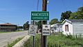
A sign marking the village limits of Manchester.
-
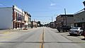
Looking east on Second Street, which is also U.S. Highway 52, in Manchester.
-

An aerial view of the village from above.
-

A public boat ramp on the Ohio River in downtown Manchester.
-
The Manchester, Ohio Library building.
-
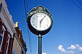
A street clock located in downtown Manchester.
-
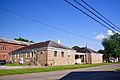
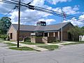
The Manchester Community Building, which also houses government offices.


See also
 In Spanish: Manchester (Ohio) para niños
