Franklin County, Ohio facts for kids
Quick facts for kids
Franklin County
|
|||
|---|---|---|---|

|
|||
|
|||
| Etymology: Benjamin Franklin | |||

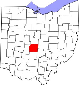
Map of Ohio highlighting Franklin County
|
|||
| Country | United States | ||
| State | Ohio | ||
| Region | Central Ohio | ||
| City | Columbus | ||
| Founded | April 30, 1803 | ||
| County seat | Columbus | ||
| Area | |||
| • Total | 543.624 sq mi (1,407.977 km2) | ||
| • Land | 532.422 sq mi (1,378.966 km2) | ||
| • Water | 11.202 sq mi (29.013 km2) | ||
| Elevation | 1,132 ft (345 m) | ||
| Population | |||
| • Total | 1,323,807 | ||
| • Estimate
(2023)
|
1,326,063 |
||
| • Density | 2,435.1519/sq mi (940.2192/km2) | ||
| Gross Domestic Product | |||
| • Total | US$106.988 billion (2022) | ||
| Time zone | UTC−5 (Eastern (EST)) | ||
| • Summer (DST) | UTC−4 (EDT) | ||
| Area codes | 614 and 380 | ||
| Congressional districts | 3rd 15th |
||
| FIPS code | 39-049 | ||
Franklin County is a county in the state of Ohio. It is the most populated county in Ohio. In 2020, about 1.3 million people lived there.
Most of Franklin County is covered by its main city, Columbus. Columbus is not only the county seat but also the capital city of Ohio. It is also the largest city in Ohio.
Franklin County was created on April 30, 1803. This was less than two months after Ohio became a state. The county was named after Benjamin Franklin, a famous American leader. Long ago, Franklin County stretched all the way north to Lake Erie. Later, it was divided into smaller counties. Today, Franklin County is the center of the Columbus metropolitan area.
Franklin County, especially Columbus, is very important in American politics. It has played a key role in many presidential and congressional elections. The county is also home to one of the biggest universities in the United States, Ohio State University. Its main campus in Columbus has about 60,000 students!
Franklin County shares its name with Franklin County in Kentucky. That county is home to Frankfort, the capital of Kentucky. This is one of only two times in the U.S. where two state capitals are in counties with the same name.
Contents
History of Franklin County
The Ohio government decided to create Franklin County on March 30, 1803. Before that, the area was part of Ross County. People chose to name the county after Benjamin Franklin.
In 1816, Columbus became the capital of Ohio. Surveyors first planned the city in 1812. It officially became a city in 1816. Columbus was not Ohio's first capital. The state government had been in Chillicothe and Zanesville for a short time. Columbus was chosen because it was in the middle of the state. It also had good access to rivers, which were important for travel back then.
Before 1812, Columbus did not exist. It was designed to be the new state capital. Between 1812 and 1816, Columbus and Franklin County grew a lot. By 1813, a prison was built. By 1814, the first church, school, and newspaper were started in Columbus. The Ohio Statehouse, where the government meets, was finished in 1861. Columbus and Franklin County quickly grew in population. By 1815, Columbus had 700 people. In 1824, Columbus officially became the county seat. By 1834, its population reached 4,000, making it an official "city."
Geography and Nature
Franklin County covers about 544 square miles. Most of this area, about 532 square miles, is land. The remaining 11 square miles (about 2.1%) is water. The county is located in two land regions: the Till Plains and the Appalachian Plateau.
The county has two main rivers: the Olentangy River and the Scioto River. Important creeks include Big Darby Creek, Big Walnut Creek, and Alum Creek. There are also two large reservoirs, which are like big lakes that store water: Hoover Reservoir and Griggs Reservoir.
Neighboring Counties
Franklin County shares its borders with these counties:
- Delaware County (north)
- Fairfield County (southeast)
- Licking County (east)
- Madison County (west)
- Pickaway County (south)
- Union County (northwest)
Main Roads
Many important highways run through Franklin County, connecting it to other parts of Ohio and the country.
Population and People
The population of Franklin County has grown a lot over the years. Here's how it has changed:
| Historical population | |||
|---|---|---|---|
| Census | Pop. | %± | |
| 1810 | 3,486 | — | |
| 1820 | 10,292 | 195.2% | |
| 1830 | 14,741 | 43.2% | |
| 1840 | 25,049 | 69.9% | |
| 1850 | 42,909 | 71.3% | |
| 1860 | 50,361 | 17.4% | |
| 1870 | 63,019 | 25.1% | |
| 1880 | 86,797 | 37.7% | |
| 1890 | 124,087 | 43.0% | |
| 1900 | 164,460 | 32.5% | |
| 1910 | 221,567 | 34.7% | |
| 1920 | 283,951 | 28.2% | |
| 1930 | 361,055 | 27.2% | |
| 1940 | 388,712 | 7.7% | |
| 1950 | 503,410 | 29.5% | |
| 1960 | 682,962 | 35.7% | |
| 1970 | 833,249 | 22.0% | |
| 1980 | 869,132 | 4.3% | |
| 1990 | 961,437 | 10.6% | |
| 2000 | 1,068,978 | 11.2% | |
| 2010 | 1,163,414 | 8.8% | |
| 2020 | 1,323,807 | 13.8% | |
| 2023 (est.) | 1,326,063 | 14.0% | |
| U.S. Decennial Census 1790-1960 1900–1990 1990–2000 2010–2020 |
|||
Population in 2020
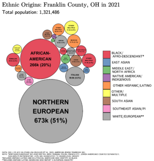
In 2020, Franklin County had 1,323,807 people. There were 540,369 households, which are groups of people living together. The county is quite diverse.
| Race | Number | Percent |
|---|---|---|
| White (NH) | 787,615 | 59.5% |
| Black or African American (NH) | 296,076 | 22.4% |
| Native American (NH) | 2,160 | 0.2% |
| Asian (NH) | 73,714 | 5.6% |
| Pacific Islander (NH) | 444 | 0.0% |
| Some Other Race (NH) | 7,212 | 0.5% |
| Mixed/Multi-Racial (NH) | 65,404 | 4.9% |
| Hispanic or Latino | 91,182 | 6.9% |
| Total | 1,323,807 | 100.0% |
About 22.9% of the people were under 18 years old. About 13.2% were 65 years or older.
Population in 2010
In 2010, Franklin County had 1,163,414 people. The average household had 2.38 people. The average family had 3.05 people. The median age was 33.4 years. This means half the people were younger than 33.4 and half were older.
The median income for a household was $49,087. This is the middle income for all households. For families, the median income was $62,372.
Economy and Jobs
Franklin County has a strong economy with many different types of jobs. Here are some of the largest employers in the county, based on a 2022 report:
| # | Employer | Type of Business | # of Employees | Percentage |
|---|---|---|---|---|
| 1 | Ohio State University | Higher Education | 33,653 | 4.90% |
| 2 | State of Ohio | Government | 22,736 | 3.31% |
| 3 | JP Morgan Chase & Company | Finance | 16,896 | 2.46% |
| 4 | Kroger Company | Retail | 11,529 | 1.68% |
| 5 | Nationwide Children's Hospital | Health Care | 11,302 | 1.65% |
| 6 | Nationwide | Insurance | 11,000 | 1.60% |
| 7 | Amazon | Retail | 9,262 | 1.35% |
| 8 | City of Columbus | Government | 8,656 | 1.26% |
| 9 | Mount Carmel Health System | Health Care | 7,887 | 1.15% |
| 10 | Honda | Manufacturer | 5,800 | 0.85% |
| — | Total employers | — | 138,721 | 20.21% |
Communities in Franklin County
Franklin County is made up of different types of communities. These include cities, villages, and townships.
Cities
- Bexley
- Canal Winchester
- Columbus (state capital and county seat)
- Dublin
- Gahanna
- Grandview Heights
- Grove City
- Groveport
- Hilliard
- New Albany
- Obetz
- Pickerington
- Reynoldsburg
- Upper Arlington
- Westerville
- Whitehall
- Worthington
Villages
- Brice
- Harrisburg
- Lithopolis
- Lockbourne
- Marble Cliff
- Minerva Park
- Riverlea
- Urbancrest
- Valleyview
Townships
- Blendon
- Brown
- Clinton
- Franklin
- Hamilton
- Jackson
- Jefferson
- Madison
- Mifflin
- Norwich
- Perry
- Plain
- Pleasant
- Prairie
- Sharon
- Truro
- Washington
- Montgomery (this township is now part of Columbus city)
- Valleyview (this township is now part of Valleyview village)
Other Communities
These are smaller communities that are not officially cities, villages, or townships:
Education
Franklin County has many school districts that serve its students.
City School Districts
- Bexley City School District
- Columbus City School District
- Dublin City School District
- Gahanna-Jefferson City School District
- Grandview Heights City School District
- Hilliard City School District
- Reynoldsburg City School District
- South-Western City School District
- Upper Arlington City School District
- Westerville City School District
- Whitehall City School District
- Worthington City School District
Local School Districts
- Canal Winchester Local School District
- Groveport Madison Local School District
- Hamilton Local School District
- Jonathan Alder Local School District
- Licking Heights Local School District
- Madison-Plains Local School District
- New Albany-Plain Local School District
- Olentangy Local School District
- Pickerington Local School District
- Teays Valley Local School District
State Schools
Ohio also has special schools in Franklin County for students with specific needs:
- Ohio State School for the Blind
- Ohio School for the Deaf
See also
 In Spanish: Condado de Franklin (Ohio) para niños
 | Percy Lavon Julian |
 | Katherine Johnson |
 | George Washington Carver |
 | Annie Easley |


