
Lincoln Village, Ohio facts for kids
Quick facts for kids
Lincoln Village, Ohio
|
|
|---|---|
.jpeg)
Sign and gateway into Lincoln Village
|
|

Location of Lincoln Village, Ohio
|
|
| Country | United States |
| State | Ohio |
| County | Franklin |
| Township | Prairie |
| Area | |
| • Total | 1.82 sq mi (4.73 km2) |
| • Land | 1.82 sq mi (4.73 km2) |
| • Water | 0.00 sq mi (0.00 km2) |
| Elevation | 909 ft (277 m) |
| Population
(2020)
|
|
| • Total | 9,702 |
| • Density | 5,316.16/sq mi (2,052.34/km2) |
| Time zone | UTC-5 (Eastern (EST)) |
| • Summer (DST) | UTC-4 (EDT) |
| FIPS code | 39-43792 |
| GNIS feature ID | 2393101 |
Lincoln Village is a special kind of community called a census-designated place (CDP). It's located in Prairie Township, Franklin County, Ohio, in the United States. You can find it on the west side of Columbus, near where two big roads, US 40 and I-270, meet. In 2020, about 9,702 people lived there.
Lincoln Village was started in 1955. It was designed to be a "planned community" by a company linked to Nationwide Insurance.
Contents
History of Lincoln Village
The idea for Lincoln Village came from Murray Lincoln, who led the Ohio Farm Bureau Federation. He wanted to create a suburban "village" back in the 1940s. Murray Lincoln was also in charge of what became Nationwide Insurance. In the early 1950s, he began working on the Lincoln Village project. He had support from the U.S. Cooperative Movement.
Lincoln believed that co-ops, which are businesses owned and run by their members, could help people. He thought they could balance private businesses and help communities. He used money from several co-op and other businesses he started to fund Lincoln Village. His company, People's Development Corporation, was formed to build it. The whole project cost about $30 million.
The plan for Lincoln Village was very detailed. It included about 9 miles of streets and a water system with a pumping station. The village was designed for 10,000 people. It was built around a 20-acre civic center. In 1953, construction began on 1,270 acres of farmland. The plans included churches, a school, a wooded park, playgrounds, and a library. A shopping center was also part of the design. Homes in the village included apartments and single-family houses.
Geography and Location
Lincoln Village is located in the western part of Franklin County, Ohio.
The Pennsylvania Railroad runs along the northern edge of Lincoln Village. Sullivant Avenue is to the south, and Interstate 270 is to the east. The western border follows Hilliard Rome Road and Norton Road. U.S. Route 40, also known as the National Road or W. Broad Street, goes right through the middle of the community. This road leads east about 9 miles to the center of Columbus.
The city of Columbus surrounds Lincoln Village to the north, west, and south. A part of Franklin Township is to the east, across I-270. According to the United States Census Bureau, Lincoln Village covers an area of about 4.75 square kilometers, all of which is land.
Nearby communities include New Rome, Rome Heights, Cherry Creek, and National Pike Little Farms.
People of Lincoln Village (Demographics)
| Historical population | |||
|---|---|---|---|
| Census | Pop. | %± | |
| 2020 | 9,702 | — | |
| U.S. Decennial Census | |||
In 2010, there were 9,032 people living in Lincoln Village. They lived in 3,734 households, and 2,265 of these were families. Most residents, about 82.1%, were White. About 6.3% were Black or African American, and 0.9% were Asian. About 10.7% of the population identified as Hispanic or Latino.
About 24.3% of households had children under 18 living with them. About 37.9% were married couples. The average household had 2.42 people, and the average family had 3.04 people.
The population included people of all ages. About 23.6% were under 18 years old. About 14.5% were 65 years or older. The average age was 38.2 years. The typical income for a household was $41,250 per year. About 15.8% of the population lived below the poverty line. This included 24.0% of those under 18.
Economy and Shopping
.jpeg)
Lincoln Village Plaza is a big shopping center on West Broad Street. It's a main place for shopping in Lincoln Village. Some of the well-known stores there include Giant Eagle, Joann Fabrics, and the Westland Area Library.
Education in Lincoln Village
.jpeg)
Students in Lincoln Village attend schools in the South-Western City School District. In 2010, about 75.8% of adults aged 25 and over in Lincoln Village had finished high school or higher education.
Lincoln Village has two elementary schools. Prairie Lincoln Elementary School is located on Amesbury Way in Lincoln Village North. It was rebuilt in 2015 and can now hold 600 students.

In Lincoln Village South, you'll find Stiles Elementary School on Stiles Avenue. It was also rebuilt around the same time and has the same capacity as Prairie Lincoln.
Parks and Recreation
Lincoln Village has several parks for residents to enjoy.
Carl Frye Park is the main park in Lincoln Village North. You can find it at 318 Darbyhurst Road. Friendship Park is the second park in Lincoln Village North. It's located between Beacon Hill Road and Deerfield Road. Lakota Park is the only park in Lincoln Village South.
-
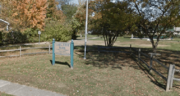
Darbyhurst Road entrance to Carl Frye Park
-
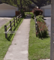
Deerfield entrance to Friendship Park
-
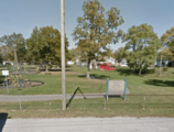
Lakota Park from Sullivant Avenue


See also
 In Spanish: Lincoln Village (Ohio) para niños
