Georgesville, Ohio facts for kids
Quick facts for kids
Georgesville, Ohio
|
|
|---|---|

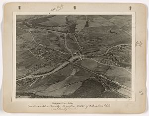
Historic photo of Georgesville, Ohio
|
|

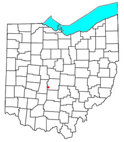
Location of Georgesville, Ohio
|
|
| Country | United States |
| State | Ohio |
| County | Franklin |
| Township | Pleasant |
| Elevation | 883 ft (269 m) |
| Time zone | UTC-5 (Eastern (EST)) |
| • Summer (DST) | UTC-4 (EDT) |
| ZIP codes |
43119 (Galloway)
|
| Area code(s) | 614 |
| GNIS feature ID | 1064712 |
Georgesville is a small community in Ohio, United States. It's not a city or town with its own government, but it's part of Pleasant Township in Franklin County. You can find it southwest of Columbus, which is the capital and biggest city in Ohio. Columbus is also the main city of Franklin County.
Contents
History of Georgesville
Early Settlements and Native Americans
Right across the Big Darby Creek from Georgesville, there's a special place called the O.C. Voss site. Long ago, it was home to a Fort Ancient village and a ceremonial mound built by Native Americans. Today, you can see a rebuilt mound along the Ancient Trail in Battelle Darby Creek Park.
In 1797, Georgesville was one of the first permanent white settlements in Central Ohio. It was founded in the same year as Franklinton. The original town was on the eastern side of Big Darby Creek, where Oak Grove Cemetery is now.
Later, a railway station was built on the western side of Big Darby. Georgesville moved to this western bank, where it is today. The old railway station is no longer there. It's interesting to note that Native American tribes, like the Shawnee Tribe, lived in the Scioto River valley long before any white settlers arrived.
Railways and Bridges
The railway line that runs through Georgesville is still active. It's used to transport farm products to grain silos in the nearby village of Lilly Chapel. Sometimes, the line is also used to store extra rail cars. This railway line is known as CAMY on the Ohio Rail Map. It ends just west of Lilly Chapel, but its old path continues west towards London, Ohio.
The current rail bridge crosses the Darby Creek just south of where the Little Darby and Big Darby creeks meet. This bridge is made of steel beams. Parts of it are built on the foundations of an even older rail bridge.
Alkire Road, which goes east and west out of Georgesville, used to have two wooden covered bridges. These bridges crossed the Big and Little Darby creeks. Later, these wooden bridges were replaced by steel truss bridges. One was a Pratt truss over Little Darby, and the other was a Camelback truss over Big Darby.
In the 1990s, these steel bridges were replaced again with modern reinforced concrete bridges. Before the old truss bridges were taken down, engineers tested them to see how much weight they could hold. This testing helped civil engineers learn a lot about how these types of bridges worked.
Flooding and Conservation
In 1913, Georgesville, like many other places in Ohio, experienced a major flood.
Today, the Darby Creek waterways are important entry points for Battelle Darby Creek Park. The Darby watershed is special because it has many different kinds of plants and animals living in its waters. This is thanks to conservation efforts in the area. The creeks have even been given special State and National designations as Scenic Rivers. The park is part of the Columbus and Franklin County Metro Park System. Other parks in the system are located upstream and downstream, forming the western edge of the metro park system.
Battelle is a research and development organization based in Columbus, Ohio. They have been involved with the establishment of these parks for a long time.
Trails and Community Events
The Camp Chase Multi-Use Trail runs right next to the active railway line through Georgesville. This trail is about 16.2-mile (26.1 km) long. It's also part of the larger Ohio to Erie Trail system, which connects northeastern Ohio through Columbus to southwestern Ohio, all the way to Cincinnati.
For many years, the Georgesville Fish Fry was a popular event in the community. It was held in the village center near the old Fire Station.
Geography
Georgesville is located where Little Darby Creek and Big Darby Creek meet. These creeks are very important and are designated as State and National Scenic Rivers. They are also tributaries of the Scioto River. Much of the swampy forests and prairies around Georgesville are part of Battelle Darby Creek Park.
Notable People
- George L. Converse: He was a U.S. Representative from Ohio from 1879 to 1881. This means he was elected to represent Ohio in the United States Congress.
- John Lewis Dyer: He was a Methodist preacher who was born and grew up in Georgesville.
 | Misty Copeland |
 | Raven Wilkinson |
 | Debra Austin |
 | Aesha Ash |

