
Little Darby Creek (Ohio) facts for kids
Quick facts for kids Little Darby Creek |
|
|---|---|
 |
|
| Other name(s) |
|
| Country | United States |
| Region | Central Ohio |
| Physical characteristics | |
| Main source | 40°06′06″N 83°36′10″W / 40.10167°N 83.60278°W |
| River mouth | Big Darby Creek 827 ft (252 m) 39°53′37″N 83°13′05″W / 39.89361°N 83.21806°W |
| Type: | Scenic |
| Designated: | March 10, 1994 |
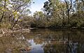
The Little Darby Creek is a small river in central Ohio. It flows into the Big Darby Creek, and together they form the Darby Creek System. These creeks are part of the larger Scioto River drainage basin.
Little Darby Creek starts near the Lafayette-Plain City Road Bridge. It then flows downstream until it meets the Big Darby Creek. This meeting point is close to the Darby Creek Metro Park. The village of Georgesville, Ohio is located near the western edge of where the two creeks join.
Contents
What Makes Little Darby Creek Special?
The Little Darby Creek and the Big Darby Creek are very important. They have been recognized for their natural beauty and special qualities.
Scenic River Status
- State Scenic River: In 1984, the state of Ohio officially named both the Little Darby and Big Darby creeks as "State Scenic Rivers." This means they are protected because of their natural beauty and importance.
- National Scenic River: Later, in 1994, these creeks received an even higher honor. They were listed as "National Scenic Rivers" by the United States. This shows how special and unique these waterways are across the country.
How the Creek Changed Over Time
For many years, the Little Darby Creek looked bigger than the Big Darby Creek where they met. This was because of a concrete dam built across the Little Darby Creek. People in the area called it "Oakie's dam."
The Franklin County Metro Park System later removed this dam. After the dam was taken out, the Little Darby Creek returned to its natural flow. Now, it is very hard to see any sign that the dam was ever there. The creek flows freely as it did before.
Images for kids
-
Little Darby Creek
