Madison County, Ohio facts for kids
Quick facts for kids
Madison County
|
|||
|---|---|---|---|

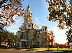
Madison County Courthouse
|
|||
|
|||

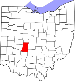
Location within the U.S. state of Ohio
|
|||
 Ohio's location within the U.S. |
|||
| Country | |||
| State | |||
| Founded | February 16, 1810 | ||
| Named for | James Madison | ||
| Seat | London | ||
| Largest city | London | ||
| Area | |||
| • Total | 467 sq mi (1,210 km2) | ||
| • Land | 466 sq mi (1,210 km2) | ||
| • Water | 0.8 sq mi (2 km2) 0.2%% | ||
| Population
(2020)
|
|||
| • Total | 43,824 |
||
| • Density | 94/sq mi (36/km2) | ||
| Time zone | UTC−5 (Eastern) | ||
| • Summer (DST) | UTC−4 (EDT) | ||
| Congressional district | 15th | ||
Madison County is a county in the middle part of Ohio, a state in the United States. In 2020, about 43,824 people lived there. The main town, or county seat, is London.
The county got its name from James Madison, who was a President of the United States. Madison County was officially started on March 1, 1810. It is also part of the larger Columbus, OH Metropolitan Statistical Area.
Contents
Exploring Madison County's Past
In 1850, Madison County was mostly a farming area. It had 24 churches and one newspaper. The total number of people living there was 10,015. The public schools taught 3,838 students.
Farmers in the county grew a lot of crops. That year, they produced over 726,000 bushels of corn. They also harvested more than 19,000 tons of hay. Animals in the county produced over 120,000 pounds of wool and nearly 129,000 pounds of butter. By 1900, the county's population had grown to 20,590 people.
Today, Madison County is home to important training centers. These include the Ohio Peace Officer Training Academy. This is where police officers in Ohio get their training. The Ohio Bureau of Criminal Identification & Investigation is also located here.
Understanding Madison County's Land
According to the U.S. Census Bureau, Madison County covers about 467 square miles. Most of this area, about 466 square miles, is land. A small part, about 0.8 square miles, is water.
Neighboring Counties Around Madison
Madison County shares its borders with several other counties.
- Union County (to the north)
- Franklin County (to the east)
- Pickaway County (to the southeast)
- Fayette County (to the south)
- Greene County (to the southwest)
- Clark County (to the west)
- Champaign County (to the northwest)
Main Roads and Highways
Several important roads run through Madison County. These highways help people travel across the county and to other parts of Ohio.
People and Population in Madison County
The number of people living in Madison County has changed over time. Here is how the population has grown since 1810.
| Historical population | |||
|---|---|---|---|
| Census | Pop. | %± | |
| 1810 | 1,603 | — | |
| 1820 | 4,799 | 199.4% | |
| 1830 | 6,190 | 29.0% | |
| 1840 | 9,025 | 45.8% | |
| 1850 | 10,015 | 11.0% | |
| 1860 | 13,015 | 30.0% | |
| 1870 | 15,633 | 20.1% | |
| 1880 | 20,129 | 28.8% | |
| 1890 | 20,057 | −0.4% | |
| 1900 | 20,590 | 2.7% | |
| 1910 | 19,902 | −3.3% | |
| 1920 | 19,662 | −1.2% | |
| 1930 | 20,253 | 3.0% | |
| 1940 | 21,811 | 7.7% | |
| 1950 | 22,300 | 2.2% | |
| 1960 | 26,454 | 18.6% | |
| 1970 | 28,318 | 7.0% | |
| 1980 | 33,004 | 16.5% | |
| 1990 | 37,068 | 12.3% | |
| 2000 | 40,213 | 8.5% | |
| 2010 | 43,435 | 8.0% | |
| 2020 | 43,824 | 0.9% | |
| U.S. Decennial Census 1790-1960 1900-1990 1990-2000 2020 |
|||
Population Details from 2010
In 2010, there were 43,435 people living in Madison County. There were 14,734 households, which are groups of people living together. About 10,580 of these were families.
Most people in the county were white (90.6%). About 6.6% were black or African American. Other groups made up smaller parts of the population. About 1.4% of the people were of Hispanic or Latino background.
The average age in the county was about 39.1 years old. About 34.1% of households had children under 18 living with them. The average household had 2.59 people.
The average income for a household was about $50,533. For families, it was about $63,397. About 11.7% of the population lived below the poverty line. This included 16.1% of those under 18.
Politics and Voting in Madison County
Madison County usually votes for the Republican Party in presidential elections. Only two Democratic presidents have won the county. These were Franklin D. Roosevelt in 1932 and 1936, and Lyndon B. Johnson in 1964.
| Year | Republican | Democratic | Third party | |||
|---|---|---|---|---|---|---|
| No. | % | No. | % | No. | % | |
| 2024 | 14,737 | 70.98% | 5,713 | 27.52% | 312 | 1.50% |
| 2020 | 13,835 | 69.57% | 5,698 | 28.65% | 354 | 1.78% |
| 2016 | 11,631 | 66.76% | 4,779 | 27.43% | 1,011 | 5.80% |
| 2012 | 10,342 | 58.91% | 6,845 | 38.99% | 370 | 2.11% |
| 2008 | 10,606 | 60.57% | 6,532 | 37.30% | 372 | 2.12% |
| 2004 | 11,117 | 63.90% | 6,203 | 35.65% | 78 | 0.45% |
| 2000 | 8,892 | 60.63% | 5,287 | 36.05% | 488 | 3.33% |
| 1996 | 6,871 | 51.20% | 5,072 | 37.79% | 1,478 | 11.01% |
| 1992 | 6,865 | 48.79% | 3,998 | 28.41% | 3,208 | 22.80% |
| 1988 | 8,303 | 70.26% | 3,421 | 28.95% | 93 | 0.79% |
| 1984 | 8,979 | 74.91% | 2,928 | 24.43% | 80 | 0.67% |
| 1980 | 7,166 | 63.14% | 3,565 | 31.41% | 619 | 5.45% |
| 1976 | 7,074 | 58.17% | 4,885 | 40.17% | 202 | 1.66% |
| 1972 | 8,372 | 75.67% | 2,484 | 22.45% | 208 | 1.88% |
| 1968 | 5,882 | 57.15% | 2,780 | 27.01% | 1,631 | 15.85% |
| 1964 | 4,945 | 48.44% | 5,264 | 51.56% | 0 | 0.00% |
| 1960 | 7,256 | 66.37% | 3,677 | 33.63% | 0 | 0.00% |
| 1956 | 6,483 | 69.28% | 2,875 | 30.72% | 0 | 0.00% |
| 1952 | 6,279 | 66.40% | 3,177 | 33.60% | 0 | 0.00% |
| 1948 | 4,730 | 58.44% | 3,356 | 41.46% | 8 | 0.10% |
| 1944 | 5,546 | 62.17% | 3,374 | 37.83% | 0 | 0.00% |
| 1940 | 5,904 | 57.35% | 4,390 | 42.65% | 0 | 0.00% |
| 1936 | 4,843 | 47.81% | 5,184 | 51.17% | 103 | 1.02% |
| 1932 | 4,631 | 49.13% | 4,722 | 50.10% | 73 | 0.77% |
| 1928 | 5,522 | 68.13% | 2,527 | 31.18% | 56 | 0.69% |
| 1924 | 4,829 | 61.97% | 2,685 | 34.46% | 278 | 3.57% |
| 1920 | 5,397 | 58.76% | 3,769 | 41.03% | 19 | 0.21% |
| 1916 | 2,809 | 50.92% | 2,667 | 48.35% | 40 | 0.73% |
| 1912 | 2,271 | 43.37% | 2,172 | 41.48% | 793 | 15.15% |
| 1908 | 3,051 | 54.93% | 2,430 | 43.75% | 73 | 1.31% |
| 1904 | 3,164 | 59.07% | 2,103 | 39.26% | 89 | 1.66% |
| 1900 | 3,197 | 55.58% | 2,493 | 43.34% | 62 | 1.08% |
| 1896 | 3,308 | 54.01% | 2,751 | 44.91% | 66 | 1.08% |
| 1892 | 2,594 | 50.93% | 2,292 | 45.00% | 207 | 4.06% |
| 1888 | 2,708 | 50.71% | 2,376 | 44.49% | 256 | 4.79% |
| 1884 | 2,706 | 52.28% | 2,391 | 46.19% | 79 | 1.53% |
| 1880 | 2,680 | 53.09% | 2,305 | 45.66% | 63 | 1.25% |
| 1876 | 2,191 | 50.24% | 2,145 | 49.19% | 25 | 0.57% |
| 1872 | 1,934 | 54.25% | 1,625 | 45.58% | 6 | 0.17% |
| 1868 | 1,682 | 52.04% | 1,550 | 47.96% | 0 | 0.00% |
| 1864 | 1,688 | 58.94% | 1,176 | 41.06% | 0 | 0.00% |
| 1860 | 1,417 | 53.03% | 1,016 | 38.02% | 239 | 8.94% |
| 1856 | 997 | 46.85% | 656 | 30.83% | 475 | 22.32% |
| Year | Republican | Democratic | Third party(ies) | |||
|---|---|---|---|---|---|---|
| No. | % | No. | % | No. | % | |
| 2024 | 13,347 | 65.24% | 6,322 | 30.90% | 789 | 3.86% |
Learning in Madison County
Schools for Young People
Several school districts serve the students of Madison County. These districts help provide education from kindergarten through high school.
- Fairbanks Local School District
- Jefferson Local School District
- Jonathan Alder Local School District
- London City School District
- Madison-Plains Local School District
- Mechanicsburg Exempted Village School District
Local Libraries for Reading and Research
The following libraries are important places for learning and reading in Madison County. They offer books, computers, and other resources to the community.
- Hurt/Battelle Memorial Library in West Jefferson
- London Public Library in London
- Mount Sterling Public Library in Mount Sterling
- Plain City Public Library in Plain City
Communities of Madison County
Cities in the County
Villages in the County
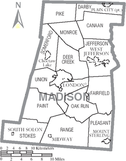
Townships in the County
Townships are smaller areas of land within a county.
- Canaan
- Darby
- Deer Creek
- Fairfield
- Jefferson
- Monroe
- Oak Run
- Paint
- Pike
- Pleasant
- Range
- Somerford
- Stokes
- Union
Census-Designated Places
These are areas that are like towns but are not officially incorporated as cities or villages.
Unincorporated Communities
These are small communities that do not have their own local government.
- Amity
- Big Plain
- Chenoweth
- Chrisman
- Florence
- Gillivan
- Kileville
- Kiousville
- Lilly Chapel
- Madison Lake
- McClimansville
- McKendree
- Newport
- Range
- Resaca
- Rosedale
- Rupert
- Summerford
- Tradersville
- Wrightsville
More to Explore
See also
 In Spanish: Condado de Madison (Ohio) para niños
 | George Robert Carruthers |
 | Patricia Bath |
 | Jan Ernst Matzeliger |
 | Alexander Miles |


