Fayette County, Ohio facts for kids
Quick facts for kids
Fayette County
|
|||
|---|---|---|---|

|
|||
|
|||

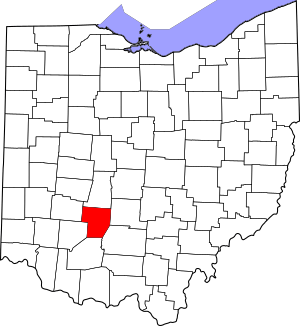
Location within the U.S. state of Ohio
|
|||
 Ohio's location within the U.S. |
|||
| Country | |||
| State | |||
| Founded | March 1, 1810 | ||
| Named for | Marquis de Lafayette | ||
| Seat | Washington Court House | ||
| Largest city | Washington Court House | ||
| Area | |||
| • Total | 407 sq mi (1,050 km2) | ||
| • Land | 406 sq mi (1,050 km2) | ||
| • Water | 0.7 sq mi (2 km2) 0.2%% | ||
| Population
(2020)
|
|||
| • Total | 28,951 | ||
| • Density | 71.13/sq mi (27.46/km2) | ||
| Time zone | UTC−5 (Eastern) | ||
| • Summer (DST) | UTC−4 (EDT) | ||
| Congressional districts | 2nd, 15th | ||
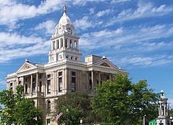
Fayette County is a county in the U.S. state of Ohio. In 2020, about 28,951 people lived there. The county seat, which is like the main government town, is Washington Court House. This is also the biggest city in the county.
Fayette County was created on March 1, 1810. It was named after the Marquis de Lafayette. He was a French officer who helped the American Army during the Revolutionary War. The county is part of a larger area called the Washington Court House, OH Micropolitan Statistical Area.
Contents
History of Fayette County
Fayette County started on March 1, 1810. It was formed from parts of two other counties: Highland and Ross.
The county got its name from Marie-Joseph Motier, Marquis de La Fayette. He was a French general and a politician. He supported the American colonists during the American Revolutionary War. He also played a big part in the French Revolution.
Parks and Trails
Fayette County has some great trails for outdoor activities.
Popular Trails
- Tri-County Triangle Trail: This trail connects Washington Court House and Chillicothe.
- Clinton-Fayette Friendship Trail: This trail runs from Melvin to Borum Road. It also has a section from Bush Road to Jamison Road.
- Xenia-Jamestown Connector: This trail opened in 2022. It lets you travel from Xenia to Octa. This trail is about 18.5 miles long.
Geography of Fayette County
Fayette County covers a total area of about 407 square miles. Most of this area, about 406 square miles, is land. Only a small part, about 0.7 square miles, is water.
Neighboring Counties
Fayette County shares borders with several other counties:
- Madison County (to the north)
- Pickaway County (to the northeast)
- Ross County (to the southeast)
- Highland County (to the south)
- Clinton County (to the southwest)
- Greene County (to the northwest)
Major Roads
 I-71
I-71 US 22
US 22 US 35
US 35 US 62
US 62 SR 38
SR 38 SR 41
SR 41 SR 435
 SR 729
 SR 734
 SR 753
Population Changes
| Historical population | |||
|---|---|---|---|
| Census | Pop. | %± | |
| 1810 | 1,854 | — | |
| 1820 | 6,316 | 240.7% | |
| 1830 | 8,182 | 29.5% | |
| 1840 | 10,984 | 34.2% | |
| 1850 | 12,726 | 15.9% | |
| 1860 | 15,935 | 25.2% | |
| 1870 | 17,170 | 7.8% | |
| 1880 | 20,364 | 18.6% | |
| 1890 | 22,309 | 9.6% | |
| 1900 | 21,725 | −2.6% | |
| 1910 | 21,744 | 0.1% | |
| 1920 | 21,518 | −1.0% | |
| 1930 | 20,755 | −3.5% | |
| 1940 | 21,385 | 3.0% | |
| 1950 | 22,554 | 5.5% | |
| 1960 | 24,775 | 9.8% | |
| 1970 | 25,461 | 2.8% | |
| 1980 | 27,467 | 7.9% | |
| 1990 | 27,466 | 0.0% | |
| 2000 | 28,433 | 3.5% | |
| 2010 | 29,030 | 2.1% | |
| 2020 | 28,951 | −0.3% | |
| U.S. Decennial Census 1790-1960 1900-1990 1990-2000 2020 |
|||
The population of Fayette County has changed over many years. In 1810, there were 1,854 people. By 2020, the population had grown to 28,951 people. This chart shows how the number of people living in the county has changed over time.
Transportation
Airport Information
Fayette County Airport is an airport in Fayette County. It is used for general aviation, which means it's for private planes and smaller flights. The county owns the airport. It is located northeast of Washington Court House.
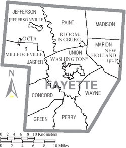
Communities in Fayette County
Fayette County has different types of communities, from a main city to small villages and other areas.
City
- Washington Court House (This is the county seat, where the main government offices are.)
Villages
- Bloomingburg
- Jeffersonville
- Milledgeville
- New Holland (Part of this village is in Pickaway County.)
- Octa
Townships
- Concord
- Green
- Jasper
- Jefferson
- Madison
- Marion
- Paint
- Perry
- Union
- Wayne
Census-designated places
These are areas that are like towns but are not officially incorporated as cities or villages.
Unincorporated Communities
These are smaller communities that are not officially part of a city or village.
- Blessing
- Bookwalter
- Boyds
- Buena Vista
- Cook
- Cunningham
- Eber
- Edgefield
- Fairview
- Georgetown
- Ghormley
- Glendon
- Hagler
- Jasper Mills
- Johnson
- Luray
- Luttrell
- Madison Mills
- Manara
- McLean
- New Martinsburg
- Parrott
- Plano
- Pleasant View
- Rock Mills
- Shady Grove
- South Plymouth
- Staunton
- West Lancaster
- White Oak
- Yankeetown
- Yatesville
See also
 In Spanish: Condado de Fayette (Ohio) para niños
 | Georgia Louise Harris Brown |
 | Julian Abele |
 | Norma Merrick Sklarek |
 | William Sidney Pittman |


