Good Hope, Ohio facts for kids
Quick facts for kids
Good Hope, Ohio
|
|
|---|---|

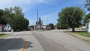
Looking north on Ohio State Route 753 in Good Hope
|
|
| Country | United States |
| State | Ohio |
| County | Fayette |
| Township | Wayne |
| Area | |
| • Total | 0.75 sq mi (1.95 km2) |
| • Land | 0.75 sq mi (1.95 km2) |
| • Water | 0.00 sq mi (0.00 km2) |
| Elevation | 935 ft (285 m) |
| Population
(2020)
|
|
| • Total | 202 |
| • Density | 268.26/sq mi (103.61/km2) |
| Time zone | UTC-5 (Eastern (EST)) |
| • Summer (DST) | UTC-4 (EDT) |
| FIPS code | 39-30828 |
| GNIS feature ID | 2628896 |
Good Hope is a small community located in Ohio, United States. It is known as a census-designated place (CDP). This means it's an area identified by the United States Census Bureau for collecting population information, even though it doesn't have its own official city government.
In 2020, about 202 people lived in Good Hope. The community is found in Fayette County, specifically within Wayne Township.
History of Good Hope
Good Hope was officially planned and laid out in 1849. However, a small village already existed there before that time. Many of the first people who settled in Good Hope came from a place called Good Hope, Pennsylvania. This is how the community got its name.
A post office was opened in Good Hope in 1851. It served the community for many years, finally closing down in 1965. For a long time, the community did not have its own system for treating waste water. This changed in 2012, when Good Hope finally got a waste treatment plant.
Geography and Location
Good Hope is situated where State Route 753 crosses with Washington-Good Hope Road and Camp Grove Road. A small stream called Indian Creek flows along the western side of Good Hope. This creek eventually joins Paint Creek a little over two miles to the south.
The community is located right in the middle of two other towns. It is halfway between Greenfield and Washington Court House. Washington Court House is the main town and administrative center, also known as the county seat, for Fayette County.
| Historical population | |||
|---|---|---|---|
| Census | Pop. | %± | |
| 2020 | 202 | — | |
| U.S. Decennial Census | |||
See also
 In Spanish: Good Hope (Ohio) para niños


