Cook, Ohio facts for kids
Quick facts for kids
Cook, Ohio
|
|
|---|---|

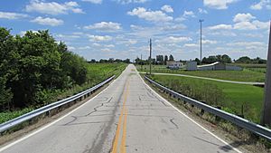
Looking east on Cook-Yankeetown Road towards US Highway 62 in Cook, Ohio
|
|
| Country | United States |
| State | Ohio |
| Counties | Fayette |
| Township | Madison |
| Elevation | 912 ft (278 m) |
| Time zone | UTC-5 (Eastern (EST)) |
| • Summer (DST) | UTC-4 (EDT) |
| ZIP code |
43143
|
| Area code(s) | 740 |
| GNIS feature ID | 1070722 |
Cook is a small place in Ohio, United States. It's known as an "unincorporated community." This means it's a group of homes or businesses that isn't officially a city or town with its own local government.
Cook is located in Madison Township, which is part of Fayette County. You can find it along Cook-Yankeetown Road. This road is also known as Fayette County Highway 34. It's just a short distance west of where it meets two bigger roads: U.S. Route 62 and State Route 3.
Contents
The Story Behind Cook's Name
Cook got its name from a person named Matthew S. Cook. He was the first owner of the land where the community now stands. Matthew Cook played an important role in the early days of the area.
How Cook Helped the Railroad
Matthew S. Cook helped the Baltimore and Ohio Railroad build its tracks. He gave them the "right of way." This means he allowed the railroad company to use a strip of his land to lay down their tracks. This was a big deal because railroads were very important for travel and moving goods back then.
Cook's Post Office History
For many years, Cook had its own post office. This was a central place for people to send and receive mail.
When the Post Office Opened and Closed
The Cook Post Office first opened its doors on January 20, 1885. It served the community for many decades. However, it eventually closed on March 31, 1933. After it closed, people in Cook started getting their mail from a different place.
Mail Service Today
Today, mail service for Cook comes from the nearby town of Mount Sterling. This means that if you live in Cook, your letters and packages are handled by the post office in Mount Sterling.
 | Roy Wilkins |
 | John Lewis |
 | Linda Carol Brown |


