Franklin County, Kentucky facts for kids
Quick facts for kids
Franklin County
|
||
|---|---|---|

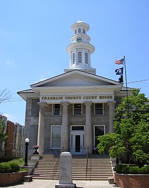
Franklin County courthouse in Frankfort
|
||
|
||

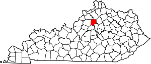
Location within the U.S. state of Kentucky
|
||
 Kentucky's location within the U.S. |
||
| Country | ||
| State | ||
| Founded | May 10, 1795 | |
| Named for | Benjamin Franklin | |
| Seat | Frankfort | |
| Largest city | Frankfort | |
| Area | ||
| • Total | 212 sq mi (550 km2) | |
| • Land | 208 sq mi (540 km2) | |
| • Water | 4.3 sq mi (11 km2) 2.0%% | |
| Population
(2020)
|
||
| • Total | 51,541 | |
| • Estimate
(2023)
|
51,644 |
|
| • Density | 243.1/sq mi (93.87/km2) | |
| Time zone | UTC−5 (Eastern) | |
| • Summer (DST) | UTC−4 (EDT) | |
| Congressional district | 1st | |
Franklin County is a county in the state of Kentucky. In 2020, about 51,541 people lived here. Its main city, or county seat, is Frankfort. Frankfort is also the capital city of Kentucky!
The county was created in 1795. It was named after Benjamin Franklin, a famous American inventor and statesman. Franklin County is part of the larger Frankfort area. It shares its name with another Franklin County in Ohio, where the city of Columbus is located.
Contents
History of Franklin County
The land that is now Franklin County was once where three original Kentucky counties met. These were Jefferson, Fayette, and Lincoln counties.
Franklin County officially started in 1795. It was formed from parts of Mercer, Shelby, and Woodford counties. Franklin was the 18th county created in Kentucky.
Geography of Franklin County
Franklin County covers about 212 square miles (549 square kilometers). Most of this area is land, with a small part being water.
How to Get Around
- Frankfort Transit (local bus service)
Main Roads
- Interstate 64
- US 127
- US 60
- US 421
- US 460
- KY 676
Neighboring Counties
Franklin County is surrounded by several other counties:
- Owen County (to the north)
- Scott County (to the east)
- Woodford County (to the southeast)
- Anderson County (to the south)
- Shelby County (to the west)
- Henry County (to the northwest)
Population of Franklin County
| Historical population | |||
|---|---|---|---|
| Census | Pop. | %± | |
| 1800 | 5,078 | — | |
| 1810 | 8,013 | 57.8% | |
| 1820 | 11,024 | 37.6% | |
| 1830 | 9,254 | −16.1% | |
| 1840 | 9,420 | 1.8% | |
| 1850 | 12,462 | 32.3% | |
| 1860 | 12,694 | 1.9% | |
| 1870 | 15,300 | 20.5% | |
| 1880 | 18,699 | 22.2% | |
| 1890 | 21,267 | 13.7% | |
| 1900 | 20,852 | −2.0% | |
| 1910 | 21,135 | 1.4% | |
| 1920 | 19,357 | −8.4% | |
| 1930 | 21,064 | 8.8% | |
| 1940 | 23,308 | 10.7% | |
| 1950 | 25,933 | 11.3% | |
| 1960 | 29,421 | 13.5% | |
| 1970 | 34,481 | 17.2% | |
| 1980 | 41,830 | 21.3% | |
| 1990 | 43,781 | 4.7% | |
| 2000 | 47,687 | 8.9% | |
| 2010 | 49,285 | 3.4% | |
| 2020 | 51,541 | 4.6% | |
| 2023 (est.) | 51,644 | 4.8% | |
| U.S. Decennial Census 1790-1960 1900-1990 1990-2000 2010-2020 |
|||
In 2000, there were 47,687 people living in Franklin County. About 22.6% of the people were under 18 years old. The average age of people in the county was 37 years.
Education in Franklin County
Students in Franklin County attend schools in two public school districts. These are Franklin County Public Schools and Frankfort Independent Schools. There are also several private schools and a university.
Franklin County Public Schools
This school district covers most of Franklin County, including a large part of Frankfort. It has several schools for different age groups:
- Bridgeport Elementary School (grades K-5)
- Collins Lane Elementary School (grades K-5)
- Early Childhood Education Center (grades K-1)
- Elkhorn Elementary School (grades 2–5)
- Hearn Elementary School (grades 2–5)
- Peaks Mill Elementary School (grades 2–5)
- Westridge Elementary School (grades K-5)
- Bondurant Middle School (grades 6–8)
- Elkhorn Middle School (grades 6–8)
- Franklin County High School (grades 9–12)
- Western Hills High School (grades 9–12)
- The Academy (grades 9–12) (This school helps students who might be having problems.)
- Franklin County Career and Technical Center (grades 9–12) (This center helps high school students learn job skills.)
Frankfort Independent Schools
This district serves specific areas of Frankfort, like downtown and the area around the state capitol building. It has two schools:
- Second Street School (grades K-6)
- Frankfort High School (grades 7–12)
Private Schools
- Capital Day School (grades PreK-8)
- Frankfort Christian Academy (grades K-12)
- Good Shepherd Catholic School (grades PreK-8)
University
Parks in Franklin County
Franklin County has many parks where people can enjoy nature and outdoor activities:
- Capitol View Park
- Cove Spring Park and Nature Preserve
- Dolly Graham Park
- East Frankfort Park
- Josephine Sculpture Park
- Juniper Hill Park and Golf Course
- Lakeview Park and Golf Course
- Leslie Morris Park on Fort Hill: This park has 120 acres of woods. It overlooks downtown Frankfort. You can find trails that show you the remains of old forts. These forts were used by Union soldiers to protect the city during a Civil War battle in 1864.
- Riverview Park and riverside walk
- Todd Park
Communities in Franklin County
City
- Frankfort (This is the county seat, where the main government offices are.)
Unincorporated Communities
These are smaller towns or areas that are not officially cities.
- Bald Knob
- Bridgeport
- Forks of Elkhorn
- Jett
- Peaks Mill
- Switzer
See also
 In Spanish: Condado de Franklin (Kentucky) para niños
 | Madam C. J. Walker |
 | Janet Emerson Bashen |
 | Annie Turnbo Malone |
 | Maggie L. Walker |


