Anderson County, Kentucky facts for kids
Quick facts for kids
Anderson County
|
|
|---|---|

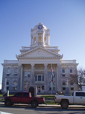
Anderson County courthouse in Lawrenceburg
|
|

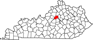
Location within the U.S. state of Kentucky
|
|
 Kentucky's location within the U.S. |
|
| Country | |
| State | |
| Founded | 1827 |
| Named for | Richard Clough Anderson Jr. |
| Seat | Lawrenceburg |
| Largest city | Lawrenceburg |
| Area | |
| • Total | 204 sq mi (530 km2) |
| • Land | 202 sq mi (520 km2) |
| • Water | 2.4 sq mi (6 km2) 1.2% |
| Population
(2020)
|
|
| • Total | 23,852 |
| • Estimate
(2023)
|
24,613 |
| • Density | 116.92/sq mi (45.14/km2) |
| Time zone | UTC−5 (Eastern) |
| • Summer (DST) | UTC−4 (EDT) |
| Congressional districts | 1st, 6th |
Anderson County is a county in Kentucky, a state in the United States. It is located in the Outer Bluegrass area of Kentucky. Anderson County is the 48th most populated county in Kentucky. It is also the ninth fastest-growing county in the state.
As of July 1, 2022, about 24,224 people lived in Anderson County. This was a small increase from 2020. The county has grown quite a bit since 2010.
Anderson County was officially created on February 1, 1827. It was formed from parts of three other counties: Franklin, Washington, and Mercer. This made it the 82nd county in Kentucky. The county was named after Richard Clough Anderson Jr.. He was an important person who served in the government and as a U.S. minister to Colombia. The main city and county seat is Lawrenceburg. Later, in 1854, the borders of Anderson County were slightly changed.
Anderson County covers about 202 square miles of land. It has 25 places that are officially recognized as populated areas. Lawrenceburg is the biggest city in the county, both in terms of people and size. Anderson County is also part of the larger Bluegrass Area Development District. It is also part of the area around Frankfort, the state capital.
Contents
Geography of Anderson County
Anderson County is known for its beautiful Bluegrass landscape. The U.S. Geographic Names Information System (GNIS) helps identify places.
- Kentucky's GNIS number is 21.
- Anderson County's GNIS number is 5.
Cities and Towns
Anderson County has one main city and several smaller communities.
- Lawrenceburg is the county seat. This means it's where the county government is located.
Other Communities
These are smaller places where people live, but they are not officially cities or towns.
Places from the Past
Some places in Anderson County used to be towns but are now "ghost towns." This means people no longer live there.
Neighboring Counties
Anderson County shares its borders with seven other counties:
- Franklin County (to the north)
- Woodford County (to the east)
- Mercer County (to the southeast)
- Washington County (to the south)
- Nelson County (to the southwest)
- Spencer County (to the west)
- Shelby County (to the northwest)
People of Anderson County
| Historical population | |||
|---|---|---|---|
| Census | Pop. | %± | |
| 1830 | 4,520 | — | |
| 1840 | 5,452 | 20.6% | |
| 1850 | 6,260 | 14.8% | |
| 1860 | 7,404 | 18.3% | |
| 1870 | 5,449 | −26.4% | |
| 1880 | 9,361 | 71.8% | |
| 1890 | 10,610 | 13.3% | |
| 1900 | 10,051 | −5.3% | |
| 1910 | 10,146 | 0.9% | |
| 1920 | 9,982 | −1.6% | |
| 1930 | 8,494 | −14.9% | |
| 1940 | 8,936 | 5.2% | |
| 1950 | 8,984 | 0.5% | |
| 1960 | 8,618 | −4.1% | |
| 1970 | 9,358 | 8.6% | |
| 1980 | 12,567 | 34.3% | |
| 1990 | 14,571 | 15.9% | |
| 2000 | 19,111 | 31.2% | |
| 2010 | 21,421 | 12.1% | |
| 2020 | 23,852 | 11.3% | |
| 2023 (est.) | 24,613 | 14.9% | |
| U.S. Decennial Census 1790-1960 1900-1990 1990-2000 2010-2020 |
|||
The census of 2020 showed that 23,852 people lived in Anderson County. There were about 9,539 homes. The average family size was 2.57 people. The county had about 106 people per square mile.
Most people in the county, about 95.10%, were White. About 2.10% were Black or African American. Smaller groups included Native American, Asian, and Pacific Islander people. About 1.9% of the population was Hispanic or Latino.
About 33.80% of households had children under 18 living with them. About 50.2% were married couples. The average household had 2.57 people. The average family had 3.03 people.
The age breakdown in 2020 was:
- 23.5% were under 18 years old.
- 11.8% were between 15 and 24 years old.
- 24.3% were between 25 and 44 years old.
- 28.9% were between 45 and 64 years old.
- 16.3% were 65 years or older.
The average age in the county was 41.4 years. The population was about 51% female and 49% male.
The median household income was $55,334. This is the middle income for all households. The median family income was $67,681. The average income per person was $27,250. About 15.7% of the total population lived below the poverty line. This included 23.8% of children under 18.
See also
 In Spanish: Condado de Anderson (Kentucky) para niños
 | Tommie Smith |
 | Simone Manuel |
 | Shani Davis |
 | Simone Biles |
 | Alice Coachman |

