
Jefferson County, Kentucky facts for kids
Quick facts for kids
Jefferson County
|
||
|---|---|---|
|
Consolidated city-county
|
||

Jefferson County Courthouse (now Louisville Metro Hall) in downtown Louisville
|
||
|
||

Location within the U.S. state of Kentucky
|
||
 Kentucky's location within the U.S. |
||
| Country | ||
| State | ||
| Founded | 1780 | |
| Named for | Thomas Jefferson | |
| Seat | Louisville | |
| Largest city | Louisville | |
| Area | ||
| • Total | 398 sq mi (1,030 km2) | |
| • Land | 380 sq mi (1,000 km2) | |
| • Water | 17 sq mi (40 km2) 4.3%% | |
| Population
(2020)
|
||
| • Total | 782,969 | |
| • Estimate
(2023)
|
772,144 |
|
| • Density | 1,967.3/sq mi (759.6/km2) | |
| Time zone | UTC−5 (Eastern) | |
| • Summer (DST) | UTC−4 (EDT) | |
| Congressional districts | 3rd, 2nd | |

Jefferson County is a county in the north central part of Kentucky, a state in the United States. In 2020, about 782,969 people lived here. This makes it the county with the most people in Kentucky. It has more than twice the population of Fayette County, which is the second largest.
Since 2003, Jefferson County and the city of Louisville have joined together. This means they share the same land, people, and government. The new government is called the Louisville/Jefferson County Metro Government, or Louisville Metro. Louisville is also the main city, or county seat, for the county. Jefferson County is the center of a larger area called the Louisville-Jefferson County, KY-IN Metropolitan Statistical Area. People often call this area Kentuckiana.
Contents
History of Jefferson County
Jefferson County was created in June 1780. It was part of Virginia back then. The Virginia government divided Kentucky County into three new counties: Fayette, Jefferson, and Lincoln. The county was named after Thomas Jefferson, who was the governor of Virginia at that time. When Kentucky became a state on June 1, 1792, Jefferson County was one of its nine original counties.

In 1778, during the American Revolutionary War, a group of soldiers led by George Rogers Clark and 60 settlers started the first American settlement in the county. They settled on Corn Island in the Ohio River. The next year, they moved to the mainland and started the city of Louisville.
Richard Mentor Johnson, who later became the 9th Vice President of the United States, was born in Jefferson County in 1780. His family lived near Beargrass Creek. The last major attack by Native Americans in what is now Jefferson County was the Chenoweth Massacre on July 17, 1789.
Geography and Location
Jefferson County covers a total area of about 398 square miles. Most of this is land, about 380 square miles. The rest, about 17 square miles, is water. The Ohio River forms the northern border of the county, separating it from the state of Indiana.
The highest point in the county is South Park Hill. It is about 902 feet (275 meters) tall and is in the southern part of the county. The lowest point is about 383 feet (117 meters) along the Ohio River, near West Point.
Neighboring Counties
Jefferson County shares its borders with several other counties:
- Bullitt County (to the south)
- Shelby County (to the east)
- Oldham County (to the northeast)
- Spencer County (to the southeast)
- Hardin County (to the southwest)
- Clark County, Indiana (to the north, across the Ohio River)
- Harrison County, Indiana (to the west, across the Ohio River)
- Floyd County, Indiana (to the northwest, across the Ohio River)
Transportation and Roads
Jefferson County has many important roads and highways that help people travel around. These include major interstate highways and U.S. routes.
 I-64
I-64 I-65
I-65 I-71
I-71 I-264
I-264 I-265
I-265 US 31W
 US 42
US 42 US 60
US 60
US 60 Alt. US 150
 KY 61
KY 61 KY 146
 KY 148
 KY 155
 KY 660
 KY 841
 KY 864
 KY 907
 KY 1020
 KY 1065
 KY 1447
 KY 1531
 KY 1694
 KY 1703
 KY 1747
 KY 1819
 KY 1865
 KY 1931
 KY 1932
 KY 1934
 KY 2052
 KY 3222
Population and People
The population of Jefferson County has grown a lot over the years. Here's how the number of people living in the county has changed:
| Historical population | |||
|---|---|---|---|
| Census | Pop. | %± | |
| 1790 | 4,765 | — | |
| 1800 | 8,754 | 83.7% | |
| 1810 | 13,399 | 53.1% | |
| 1820 | 20,768 | 55.0% | |
| 1830 | 23,979 | 15.5% | |
| 1840 | 36,346 | 51.6% | |
| 1850 | 59,831 | 64.6% | |
| 1860 | 89,404 | 49.4% | |
| 1870 | 118,953 | 33.1% | |
| 1880 | 146,010 | 22.7% | |
| 1890 | 188,598 | 29.2% | |
| 1900 | 232,549 | 23.3% | |
| 1910 | 262,920 | 13.1% | |
| 1920 | 286,369 | 8.9% | |
| 1930 | 355,350 | 24.1% | |
| 1940 | 385,392 | 8.5% | |
| 1950 | 484,615 | 25.7% | |
| 1960 | 610,947 | 26.1% | |
| 1970 | 695,055 | 13.8% | |
| 1980 | 685,004 | −1.4% | |
| 1990 | 664,937 | −2.9% | |
| 2000 | 693,604 | 4.3% | |
| 2010 | 741,096 | 6.8% | |
| 2020 | 782,969 | 5.7% | |
| 2023 (est.) | 772,144 | 4.2% | |
| U.S. Decennial Census 1790–1960 1900–1990 1990–2000 2010–2020 |
|||
Who Lives in Jefferson County?
The 2020 census showed the different groups of people living in Jefferson County.
| Race / Ethnicity | Pop 2000 | Pop 2010 | Pop 2020 | % 2000 | % 2010 | % 2020 |
|---|---|---|---|---|---|---|
| White alone (NH) | 530,056 | 522,561 | 490,251 | 76.42% | 70.51% | 62.61% |
| Black or African American alone (NH) | 130,003 | 152,451 | 167,067 | 18.74% | 20.57% | 21.34% |
| Native American or Alaska Native alone (NH) | 1,409 | 1,492 | 1,441 | 0.20% | 0.20% | 0.18% |
| Asian alone (NH) | 9,562 | 16,171 | 26,944 | 1.38% | 2.18% | 3.44% |
| Pacific Islander alone (NH) | 224 | 403 | 559 | 0.03% | 0.05% | 0.07% |
| Some Other Race alone (NH) | 1,143 | 1,255 | 3,707 | 0.16% | 0.17% | 0.47% |
| Mixed Race/Multi-Racial (NH) | 8,837 | 14,221 | 33,979 | 1.27% | 1.92% | 4.34% |
| Hispanic or Latino (any race) | 12,370 | 32,542 | 59,021 | 1.78% | 4.39% | 7.54% |
| Total | 693,604 | 741,096 | 782,969 | 100.00% | 100.00% | 100.00% |
In 2000, there were 693,604 people living in the county. There were 287,012 households, and 183,113 families. The county had about 1,801 people per square mile. About 29.6% of households had children under 18. About 45.2% were married couples. The average household had 2.37 people. The average family had 2.97 people.
The population was spread out by age. About 24.3% were under 18. About 30.4% were between 25 and 44 years old. The median age was 37 years. For every 100 females, there were about 91.6 males. The average income for a household in 2018 was $54,357. About 14.8% of the people lived below the poverty line. This included 22.1% of those under 18.
Towns and Cities
When Louisville Metro was formed in 2003, the smaller cities and towns in Jefferson County did not disappear. Their local governments still exist. However, Louisville Metro now handles many services that the county government used to provide for these towns. The original city of Louisville became part of the new city-county government.

Here are some of the communities in Jefferson County:
- Anchorage
- Audubon Park
- Bancroft
- Barbourmeade
- Beechwood Village
- Bellemeade
- Bellewood
- Blue Ridge Manor
- Briarwood
- Broad Fields
- Broeck Pointe
- Brownsboro Farm
- Brownsboro Village
- Cambridge
- Cherrywood Village
- Coldstream
- Creekside
- Crossgate
- Douglass Hills
- Druid Hills
- Fairmeade
- Fincastle
- Fisherville
- Forest Hills
- Glenview Hills
- Glenview Manor
- Glenview
- Goose Creek
- Graymoor-Devondale
- Green Spring
- Heritage Creek
- Hickory Hill
- Hills and Dales
- Hollow Creek
- Hollyvilla
- Houston Acres
- Hurstbourne Acres
- Hurstbourne
- Indian Hills
- Jeffersontown
- Keeneland
- Kingsley
- Langdon Place
- Lincolnshire
- Louisville
- Lyndon
- Lynnview
- Manor Creek
- Maryhill Estates
- Meadow Vale
- Meadowbrook Farm
- Meadowview Estates
- Middletown
- Mockingbird Valley
- Moorland
- Murray Hill
- Norbourne Estates
- Northfield
- Norwood
- Old Brownsboro Place
- Parkway Village
- Plantation
- Plymouth Village
- Poplar Hills
- Prospect
- Richlawn
- Riverwood
- Rolling Fields
- Rolling Hills
- Seneca Gardens
- Shively
- South Park View
- Spring Mill
- Spring Valley
- Springlee
- St. Matthews
- St. Regis Park
- Strathmoor Manor
- Strathmoor Village
- Sycamore
- Ten Broeck
- Thornhill
- Watterson Park
- Wellington
- West Buechel
- Westwood
- Whipps Millgate
- Wildwood
- Windy Hills
- Woodland Hills
- Woodlawn Park
- Worthington Hills
Some areas, like Buechel, Fairdale, Fern Creek, Highview, Newburg, Okolona, Pleasure Ridge Park, St. Dennis, Valley Station, and Waverly Hills, were once separate places. After 2003, they became neighborhoods within the new Louisville Metro city limits.
Education in Jefferson County
The public schools in Jefferson County are managed by two main districts. Most students attend schools in the Jefferson County School District (JCPS). There is also the Anchorage Independent School District, which serves students from kindergarten to 8th grade. After 8th grade, students in Anchorage can choose to go to JCPS schools or schools in Oldham County Schools. The Kentucky School for the Blind, a special school run by the state, is also located in Louisville.
Images for kids
-
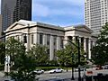
The Jefferson County Courthouse, now known as Louisville Metro Hall, in downtown Louisville.
See also
 In Spanish: Condado de Jefferson (Kentucky) para niños
