Plantation, Kentucky facts for kids
Quick facts for kids
Plantation, Kentucky
|
|
|---|---|

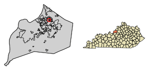
Location of Plantation in Jefferson County, Kentucky
|
|
| Country | United States |
| State | Kentucky |
| County | Jefferson |
| Incorporated | 1960 |
| Area | |
| • Total | 0.20 sq mi (0.52 km2) |
| • Land | 0.20 sq mi (0.52 km2) |
| • Water | 0.00 sq mi (0.00 km2) |
| Elevation | 627 ft (191 m) |
| Population
(2020)
|
|
| • Total | 826 |
| • Density | 4,089.11/sq mi (1,579.02/km2) |
| Time zone | UTC-5 (Eastern (EST)) |
| • Summer (DST) | UTC-4 (EDT) |
| ZIP Code |
40242
|
| FIPS code | 21-61554 |
| GNIS feature ID | 2404535 |
Plantation is a small city in Jefferson County, Kentucky, United States. It is part of the larger Louisville Metro government area. In 2020, about 826 people lived there.
History of Plantation
Plantation was first built on land that used to be farms. Later, more land was added from a large farm called Palmer-Ball. The city was officially started in 1960.
A big part of Plantation's early history involves the Plantation Swim Club. This club was created in 1956. It was famous for hosting the National Swim and Diving Championships, which were even shown on TV! The swim club closed in 2004.
Some of the original land was given to the Catholic Church. This land was used to build the Mother of Good Counsel parish and school. Today, that building is home to Portland Christian School.
Where is Plantation?
Plantation is located in the northeastern part of Jefferson County. It is about 10 miles (16 km) southwest of Downtown Louisville.
The city is surrounded by other small communities. To the northeast is Langdon Place, to the southeast is Westwood, and to the south is Briarwood. In all other directions, Plantation is bordered by the larger Louisville/Jefferson County area.
Plantation is a small city, covering about 0.2 square miles (0.52 square kilometers) of land. There is no water area within the city limits.
The city's borders are Westport Road to the south and Stonehurst Drive to the east. Colonel Drive goes north to Turnside Drive, which is the northern border. Blossom Lane and Bayou Way extend west to the city's western edge.
People in Plantation
The number of people living in Plantation has changed over the years.
- In 1970, there were 895 people.
- In 1980, the population grew to 969.
- By 1990, it went down to 830.
- In 2000, there were 902 people.
- In 2010, the population was 832.
- In 2020, 826 people lived in Plantation.
According to the 2000 census, there were 902 people living in the city. Most people were White (about 89%). About 8% were African American, and smaller numbers were Asian, Native American, or from other backgrounds. About 1% of the population was Hispanic or Latino.
There were 368 households in Plantation in 2000. About 37% of these households had children under 18 living with them. Many households were married couples. The average household had about 2.45 people.
The age of people in Plantation was spread out. About 27% were under 18 years old. About 33% were between 25 and 44 years old. The average age was 36 years.
The median income for a household in the city was about $51,731 in 2000. This means half of the households earned more than this amount, and half earned less. For families, the median income was about $61,176.
See also
 In Spanish: Plantation (Kentucky) para niños
 | Claudette Colvin |
 | Myrlie Evers-Williams |
 | Alberta Odell Jones |


