Douglass Hills, Kentucky facts for kids
Quick facts for kids
Douglass Hills, Kentucky
|
|||
|---|---|---|---|
|
|||

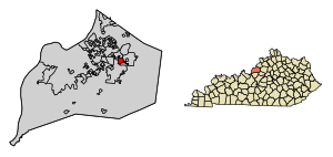
Location of Douglass Hills in Jefferson County, Kentucky
|
|||
| Country | United States | ||
| State | Kentucky | ||
| County | Jefferson | ||
| Area | |||
| • Total | 1.33 sq mi (3.44 km2) | ||
| • Land | 1.33 sq mi (3.43 km2) | ||
| • Water | 0.00 sq mi (0.00 km2) | ||
| Elevation | 712 ft (217 m) | ||
| Population
(2020)
|
|||
| • Total | 5,456 | ||
| • Density | 4,114.63/sq mi (1,588.87/km2) | ||
| Time zone | UTC-5 (Eastern (EST)) | ||
| • Summer (DST) | UTC-4 (EDT) | ||
| ZIP Code |
40243
|
||
| FIPS code | 21-22204 | ||
| GNIS feature ID | 2404240 | ||
Douglass Hills is a city located in eastern Jefferson County, Kentucky, United States. It is known as a "home rule-class city," which means it has the power to manage its own local government. In 2020, about 5,456 people lived there.
History of Douglass Hills
Douglass Hills was once a large area of farmland. This land was used for farming from 1813 all the way up to the 1970s. A part of this land was owned by a person named James J. Douglas. He owned it from 1896 until he passed away in 1917.
The city of Douglass Hills was officially created in 1973. This happened when the farmland started to be developed into neighborhoods and housing areas. When it was first formed, the city was known by a different name: "Douglass Place."
Where is Douglass Hills?
Douglass Hills is located in the eastern part of Jefferson County. It shares its borders with several other towns and cities.
- To the east and south, it borders Middletown.
- To the west, it is next to Jeffersontown.
- To the northwest, you'll find Blue Ridge Manor and Sycamore.
- To the north, it borders the larger city of Louisville.
Important roads are also close by. U.S. Route 60, also known as Shelbyville Road, runs along part of the northern edge of Douglass Hills. This road can take you about 18 miles east to Shelbyville or about 12 miles west to downtown Louisville.
Interstate 64 is another major highway. It passes about half a mile south of Douglass Hills. You can get onto Interstate 64 from Exit 17, which is Blankenbaker Parkway.
The total area of Douglass Hills is about 1.3 square miles (3.4 square kilometers). A very small part of this area, less than 1%, is water.
People of Douglass Hills
| Historical population | |||
|---|---|---|---|
| Census | Pop. | %± | |
| 1980 | 4,384 | — | |
| 1990 | 5,549 | 26.6% | |
| 2000 | 5,718 | 3.0% | |
| 2010 | 5,484 | −4.1% | |
| 2020 | 5,456 | −0.5% | |
| U.S. Decennial Census | |||
Let's look at how the population of Douglass Hills has changed over the years. In 1980, there were 4,384 people. The population grew to 5,718 in 2000. By 2020, it was 5,456 people.
In 2000, there were 2,428 households in the city. A household is a group of people living together in one home. About 29.9% of these households had children under 18 living with them. Many households, 56.6%, were married couples.
The average age of people in Douglass Hills in 2000 was 40 years old. About 22.4% of the population was under 18 years old. This means many young people and families live in the city.
The average income for a household in the city was around $60,021 in 2000. For families, the average income was about $73,670. A small number of people, about 3.0% of the population, lived below the poverty line.
See also
 In Spanish: Douglass Hills (Kentucky) para niños
 | Delilah Pierce |
 | Gordon Parks |
 | Augusta Savage |
 | Charles Ethan Porter |


